


For the first time in weeks, winds are forecast to decrease across Trinidad and Tobago heading into the weekend, leading to a reduction in wave heights in open waters.
What you need to know
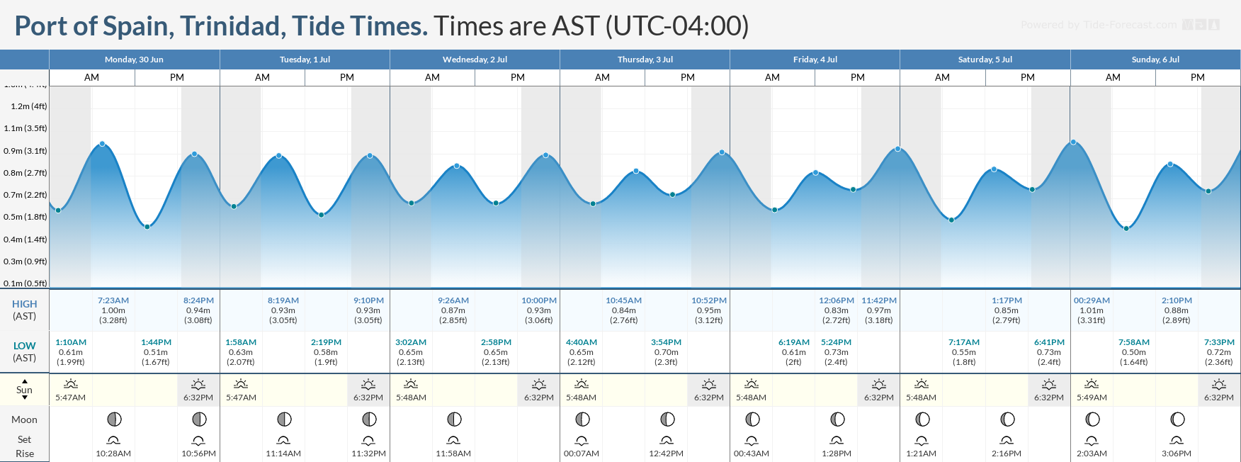
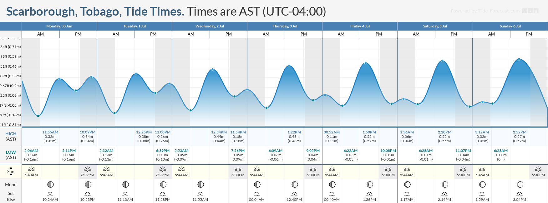
— What’s happening: While slight to moderate seas are forecast across the entire marine area over the next seven days, choppy seas are likely in sheltered areas, particularly during heavy showers and thunderstorms. Spring tides are set to begin from July 6th. Occasional long-period swells are also possible between Saturday and Sunday.
— Impacts: Choppy seas, caused by elevated winds in showers and thunderstorms, can be hazardous to smaller marine vessels, making operations difficult due to the large waves. Occasional long-period swells may produce larger waves along northern and eastern coastlines, which may lead to beach erosion.
— What Should You Do: Inexperienced mariners should avoid navigating in hazardous conditions, especially those operating smaller vessels during heavy showers and thunderstorms. If you intend to go into the water, it is recommended that you use beaches with lifeguards on duty.
Latest Alert
There are no alerts, watches, or warnings in effect for Trinidad and Tobago from the Trinidad and Tobago Meteorological Service at this time.
Trinidad and Tobago is NOT under any tropical storm or hurricane threat, watch, or warning at this time.
Seas Forecast For Trinidad and Tobago
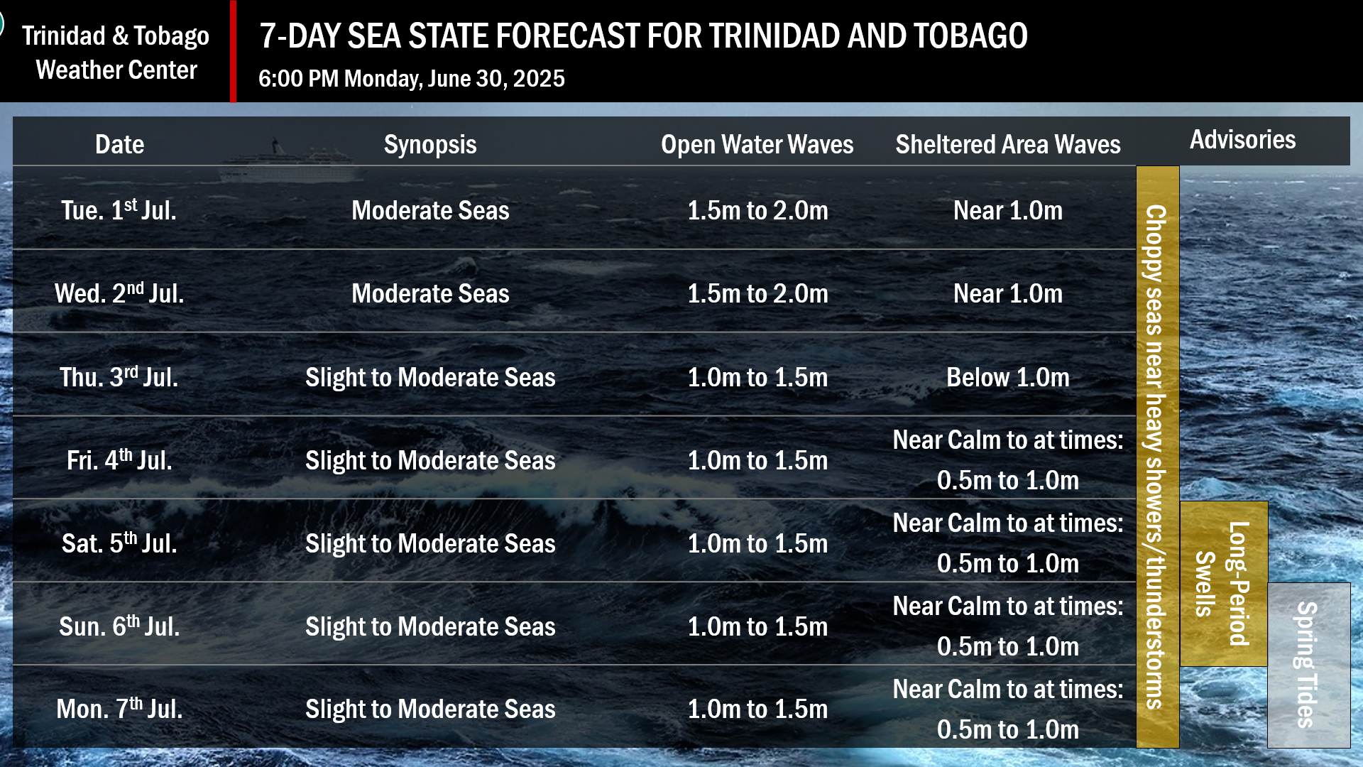
July 1st through 2nd: Winds are forecast to range between 10 and 15 knots from the east-southeast to east-northeast with gusts near or slightly above 20 knots. Seas in open waters are forecast to remain moderate, with waves ranging from 1.5 meters to 2.0 meters. In sheltered areas, waves are forecast to be near 1.0 meters, with occasionally choppy conditions in isolated heavy showers or thunderstorms. Swell periods are forecast to remain between 7 and 10 seconds, with swells coming from the north. A moderate concentration of Saharan Dust is forecast to affect visibility marginally.
July 3rd through 7th: Winds are forecast to range between 5 and 15 knots from the southeast to northeast with gusts to 20 knots. Seas in open waters are forecast to remain slight to moderate, with waves ranging from 1.0 to 1.5 meters. In sheltered areas, conditions are generally forecast to be near calm, with occasional waves reaching between 0.5 and 1.0 meters in height. Occasionally choppy conditions, particularly in the Gulf of Paria, are likely in isolated heavy showers or thunderstorms. Swell periods are forecast to remain below 8 seconds, with swells coming from the north, outside of July 5th through 6th, where swell periods may reach up to 14 seconds.
What should you do
All marine interests should practice common-sense safety. Small craft operators should seek safe harbor during heavy showers and thunderstorms. Inexperienced mariners, especially those operating smaller vessels, should avoid navigating in hazardous conditions.
Inexperienced swimmers, if intending to go into the water, should use beaches with lifeguards on duty.
Rip currents always pose a hazard on the nation’s beaches. If caught in a rip current, swim perpendicular to the current, parallel to the shore.
With the potential for long-periods swells this weekend, with spring tides coming into effect, mariners, especially small craft operators, should ensure their vessels are securely anchored or docked, as choppy or breaking wave conditions may drag the vessel onto the ocean floor or reefs in shallow waters, or even break the anchorage or mooring.


