


Elevated low-level winds are forecast to persist across Trinidad, Tobago and the Windward Islands over the next week, leading to agitated seas in open waters. A strong tropical wave on Sunday into Monday may also bring occasionally rough conditions to T&T’s northern marine areas.
What you need to know
— What & Where: Elevated low-level winds are forecast to affect the entire marine area, with higher wave heights likely in northern and eastern areas. In sheltered areas, choppy seas are likely in heavy showers and thunderstorms.
— When: Agitated seas are likely to continue through the next five days, with peak wave heights between Sunday night and Wednesday.
— Impacts: Large open water waves or choppy seas, caused by elevated winds, can be hazardous to smaller marine vessels, making operations difficult due to the large waves. Larger waves along northern and eastern coastlines may lead to beach erosion. Elevated threat of rip currents on northern and eastern coastlines.
— What Should You Do: All marine interests should exercise caution, while small craft operators should seek safe harbor when heavy showers or thunderstorms are nearby. Inexperienced mariners should avoid navigating in hazardous conditions, especially those operating smaller vessels. Inexperienced swimmers should avoid the water due to unsafe surf conditions. If you intend to go into the water, it is recommended that you use beaches with lifeguards on duty. Secure objects on the beachfront that the wave action or winds may sweep away over the next seven days.
Latest Alerts

TTMS Issues Adverse Weather Alert For T&T
Trinidad and Tobago is NOT under any tropical storm or hurricane threat, watch, or warning at this time.
Seas Forecast For Trinidad and Tobago
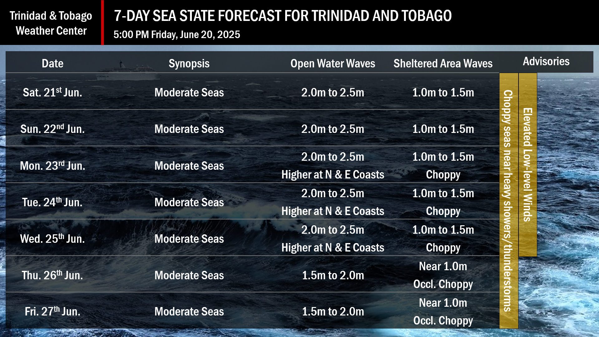
June 21st through 22nd: Winds are forecast to range between 15 and 20 knots from the northeast to southeast, with gusts to 25 knots. Seas in open waters are forecast to remain moderate with waves between 2.0 meters and 2.5 meters. In sheltered areas, waves are forecast to be between 1.0 and 1.5 meters and occasionally choppy, particularly near and during heavy showers and thunderstorms. Swell periods are forecast to range between 8 and 11 seconds from the north.
June 23rd: Winds are forecast to range between 15 and 25 knots from the southeast and northeast with gusts to 30 knots. Seas in open waters are forecast to remain moderate, with waves ranging from 2.0 meters to 2.5 meters. Seas may occasionally become rough as open water waves in northeastern areas may exceed 2.5 meters. In sheltered areas, waves are forecast to be between 1.0 and 1.5 meters, with choppy conditions.
June 24th through 25th: Winds are forecast to range between 15 and 20 knots from the east to northeast, with gusts to 25 knots. Seas in open waters are forecast to remain moderate with waves between 2.0 meters and 2.5 meters. In sheltered areas, waves are forecast to be between 1.0 and 1.5 meters and occasionally choppy, particularly near and during heavy showers and thunderstorms. Swell periods are forecast to range between 8 and 12 seconds from the north.
June 26th through 27th: Winds are forecast to range between 10 and 15 knots from the northeast to southeast, with gusts to 25 knots. Seas in open waters are forecast to remain moderate with waves between 1.5 and 2.0 meters. In sheltered areas, waves are forecast to be near 1.0 meter and occasionally choppy, particularly near and during heavy showers and thunderstorms. Swell periods are forecast to range between 8 and 11 seconds from the north.
What should you do
All marine interests need to exercise caution, while small craft operators should seek safe harbor during heavy showers and thunderstorms. Inexperienced mariners, especially those operating smaller vessels, should avoid navigating in hazardous conditions.
With elevated winds in showers or thunderstorms forecast, secure objects on the beachfront that could be swept away by wave action or winds, particularly from Friday.
Inexperienced swimmers should avoid the water during heavy showers or thunderstorms due to the likelihood of unsafe surf conditions. If they intend to go into the water, it is recommended that they use beaches with lifeguards on duty.
Rip currents always pose a hazard on the nation’s beaches. If caught in a rip current, swim perpendicular to the current, parallel to the shore. Mariners, especially small craft operators, should ensure their vessels are securely anchored or docked, as choppy or breaking wave conditions may drag the vessel onto the ocean floor or reefs in shallow waters, or even break the anchorage or mooring.


