


Periodic surges of Saharan Dust, combined with a surge in trade winds, are forecast to move across T&T over the next seven days. Mainly on Wednesday through Friday and Sunday through Monday, periods of showers and thunderstorms are likely to produce gusty winds, which will agitate the seas in both open waters and sheltered areas. Additionally, occasional long-period swells are forecast from Wednesday through Friday and the following Monday.
What you need to know
— What & Where: The entire marine area will be affected by Saharan Dust and elevated low-level winds, while northern and eastern regions are forecast to be affected by long-period swells. In sheltered areas, choppy seas are likely in heavy showers and thunderstorms.
— When: Peak Saharan Dust concentrations are forecast on Thursday through Saturday, with higher dust levels from next Tuesday. Elevated winds are forecast to peak between Thursday night and Sunday morning, as well as from Monday through Tuesday. Occasional long-period swells are possible from Wednesday through Friday.
— Impacts: Large open water waves or choppy seas, caused by elevated winds, can be hazardous to smaller marine vessels, making operations difficult due to the large waves. Larger waves, particularly those caused by long-period swells, along northern and eastern coastlines may lead to beach erosion. Elevated threat of rip currents on northern and eastern coastlines.
— What Should You Do: All marine interests should exercise caution, while small craft operators should seek safe harbor when heavy showers or thunderstorms are nearby. Inexperienced mariners should avoid navigating in hazardous conditions, especially those operating smaller vessels. Inexperienced swimmers should avoid the water due to unsafe surf conditions, particularly over the upcoming weekend. If you intend to go into the water, it is recommended that you use beaches with lifeguards on duty. Secure objects on the beachfront that the wave action or winds may sweep away over the next seven days.
Latest Alert
There are no alerts, watches, or warnings in effect for Trinidad and Tobago from the Trinidad and Tobago Meteorological Service at this time.
Trinidad and Tobago is NOT under any tropical storm or hurricane threat, watch, or warning at this time.
Seas Forecast For Trinidad and Tobago
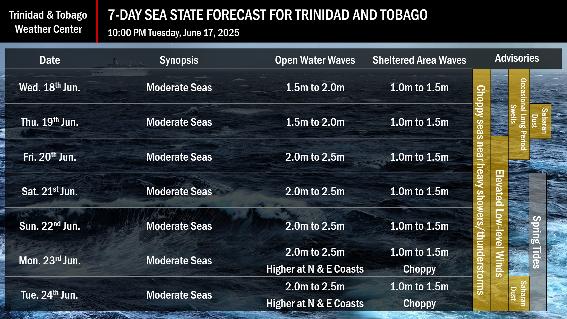
June 18th through 19th: Winds are forecast to remain from the east-northeast to southeast between 15 and 20 knots, with gusts to 25 knots. Seas in open waters are forecast to remain moderate, with waves between 1.5 meters and 2.0 meters in height. In sheltered areas, waves are forecast to be 1.0 to 1.5 meters and choppy, mainly near heavy showers and thunderstorms. Swell periods are forecast to range between 8 and 13 seconds coming in from the north to northeast.
June 20th through 23rd: Winds are forecast to range between 15 and 20 knots, with gusts to 25 knots. Seas in open waters are forecast to remain moderate with waves between 2.0 meters and 2.5 meters. In sheltered areas, waves are forecast to be between 1.0 and 1.5 meters and choppy, particularly near and during heavy showers and thunderstorms. Swell periods are forecast to range between 8 and 12 seconds from the north.
June 24th: Winds are forecast to range between 15 and 25 knots from the east-southeast and east-northeast with gusts to 30 knots. Seas in open waters are forecast to remain moderate, with waves ranging from 2.0 meters to 2.5 meters. Seas may occasionally become rough as open water waves in northeastern areas may exceed 2.5 meters. In sheltered areas, waves are forecast to be between 1.0 and 1.5 meters, with choppy conditions.
Spring tides are forecast to begin on Saturday, June 21st, 2025.
What should you do
All marine interests need to exercise caution, while small craft operators should seek safe harbor during heavy showers and thunderstorms. Inexperienced mariners, especially those operating smaller vessels, should avoid navigating in hazardous conditions.
Occasional long-period swells are forecast to bring occasional battering waves along the northern exposed coastlines of both islands, particularly Wednesday through Friday.
With elevated winds in showers or thunderstorms forecast, secure objects on the beachfront that could be swept away by wave action or winds, particularly from Friday.
Inexperienced swimmers should avoid the water during heavy showers or thunderstorms due to the likelihood of unsafe surf conditions. If they intend to go into the water, it is recommended that they use beaches with lifeguards on duty.
Rip currents always pose a hazard on the nation’s beaches. If caught in a rip current, swim perpendicular to the current, parallel to the shore. Mariners, especially small craft operators, should ensure their vessels are securely anchored or docked, as choppy or breaking wave conditions may drag the vessel onto the ocean floor or reefs in shallow waters, or even break the anchorage or mooring.


