


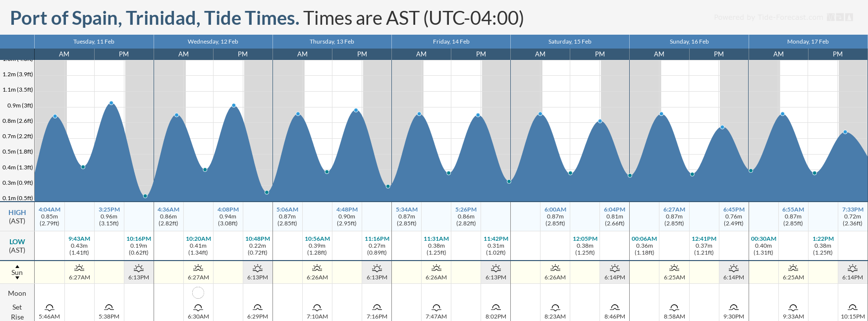
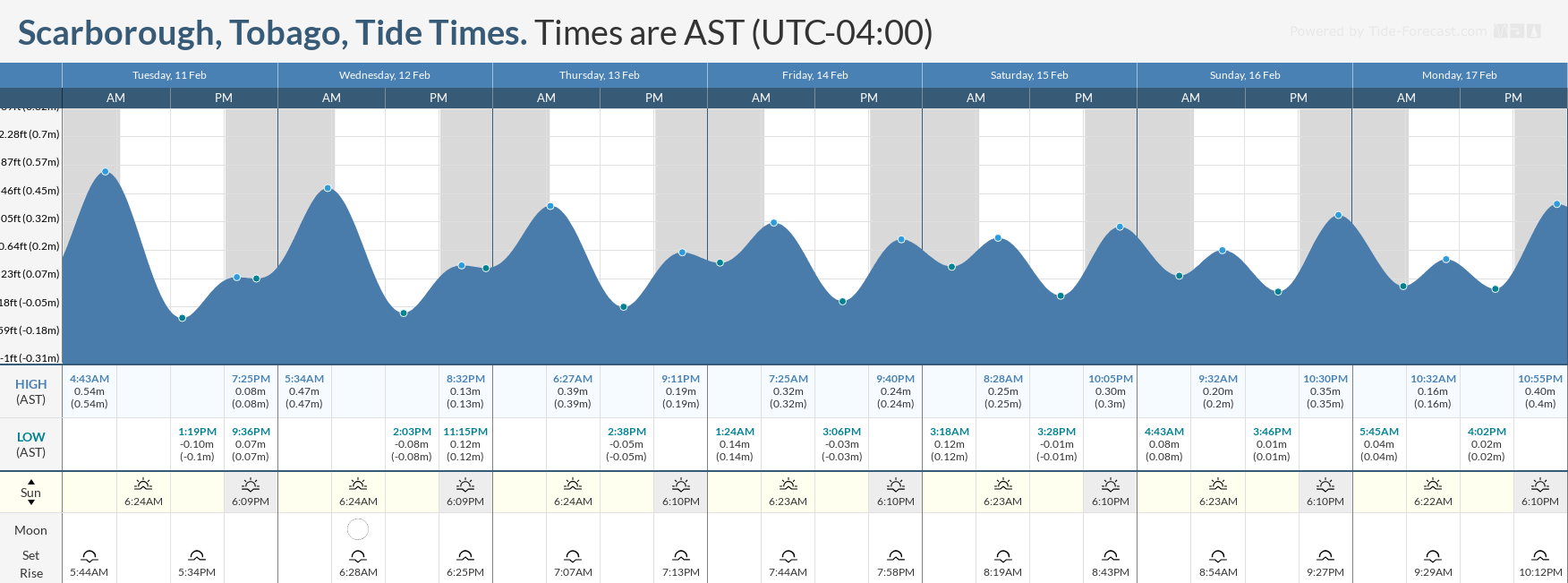
Over the next seven days, a dangerous combination of strong low-level winds offshore, long-period swells, and spring tides (through February 15th) is forecast to lead to hazardous offshore and nearshore marine conditions for Trinidad and Tobago, particularly for smaller craft.
What you need to know
— What: A strong Atlantic high-pressure system is generating strong low- to mid-level winds, up to 30 knots, across much of the tropical Atlantic Ocean, which begun to affect T&T from Monday. As a result, open water waves are forecast to reach as high as 3.0 meters, occasionally above from Wednesday evening. Additionally, occasional long-period swells up to 15 second periods are forecast, leading to occasional battering waves in nearshore areas through Friday.
— Where: Open waters north and east of Trinidad and Tobago are likely to experience higher wave heights, with long-period swells predominantly affecting the northern coastlines of both islands. Choppy conditions are likely in sheltered areas.
— When: Deteriorating marine conditions are likely from this (Tuesday) evening, with even higher wave heights from Wednesday evening, and rough seas will continue through early next week.
— Impacts: Large open water waves may be hazardous to smaller marine vessels, making operations difficult with large waves. Larger waves along northern and eastern coastlines may lead to beach erosion. Strong winds combined with large waves may build sea foam on easterly coastlines, mainly of Trinidad. Elevated threat of rip currents on northern and eastern coastlines.
— What Should You Do: All marine interests need to exercise extreme caution while small craft operators should seek safe harbor. Inexperienced mariners should avoid navigating in hazardous conditions, especially those operating smaller vessels. Inexperienced swimmers should remain out of the water due to unsafe surf conditions. If you intend to go into the water, it is recommended that you use beaches with on-duty lifeguards. Secure objects on the beach-front that the wave action or winds may sweep away.
Latest Alerts

TTMS Issues Adverse Weather Alert For T&T
Trinidad and Tobago is NOT under any tropical storm or hurricane threat, watch, or warning at this time.
Seas Forecast For Trinidad and Tobago

Wednesday: Winds are forecast to remain from the east-northeast to east-southeast between 15 and 25 knots, with gusts to 30 knots. Seas in open waters are forecast to remain moderate to rough, with waves between 2.5 and 3.0 meters, particularly in northeastern and eastern waters, while waves in sheltered areas of Trinidad remain up to 1.5 meters and waves in sheltered areas of Tobago range between 1 and 2 meters. Seas may become locally choppy or rough in showers. Swell periods are forecast between 10 and 15 seconds, with swells from mainly the north and northeast. All marine interests should exercise caution, particularly along northern and northeastern coastlines.
Thursday through Saturday: Winds are forecast to remain from the east-northeast to east-southeast between 20 and 25 knots, with gusts to 30 knots. Seas in open waters are forecast to remain rough, with waves near 3.0 meters, occasionally above in northeastern and eastern waters, while waves in sheltered areas of Trinidad remain up to 1.5 meters and waves in sheltered areas of Tobago range between 1 and 2 meters. Seas may become locally choppy or rough in showers. Swell periods are forecast between 10 and 14 seconds, with swells from mainly the north and northeast. All marine interests should exercise caution, particularly along northern and northeastern coastlines.
Sunday through Tuesday: Winds are forecast to remain from the east-northeast to east-southeast between 15 and 25 knots, with gusts to 30 knots. Seas in open waters are forecast to remain moderate to rough, with waves between 2.5 and 3.0 meters, particularly in northeastern and eastern waters, while waves in sheltered areas of Trinidad remain up to 1.5 meters and waves in sheltered areas of Tobago range between 1 and 2 meters. Seas may become locally choppy or rough in showers. Swell periods are forecast between 8 and 12 seconds, with swells from mainly the north and northeast. All marine interests should exercise caution, particularly along northern and northeastern coastlines.
What should you do
All marine interests need to exercise extreme caution, while small craft operators should seek safe harbors. Inexperienced mariners should avoid navigating in hazardous conditions, especially those operating smaller vessels.
Through Friday, occasional long-period swells are forecast to bring occasional battering waves along the northern exposed coastlines of both islands. Marine interests should also exercise caution.
With elevated winds forecast, secure objects on the beach-front that the wave action or winds may sweep away.
Due to likely unsafe surf conditions, inexperienced swimmers should stay out of the water. If you intend to go into the water, it is recommended that you use beaches with on-duty lifeguards.
Rip currents always pose a hazard on the nation’s beaches. If caught in a rip current, swim perpendicular to the current (parallel to the shore). Mariners, especially small craft operators, should ensure their vessels are securely anchored or docked, as choppy/breaking wave conditions may drag the vessel onto the ocean floor or reefs in shallow waters or even break anchorage/mooring.


