


Back-to-back tropical waves through Friday are forecast to produce isolated to scattered showers and thunderstorms, which may agitate seas near heavy rainfall and gusty winds.
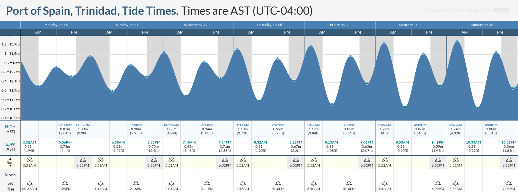
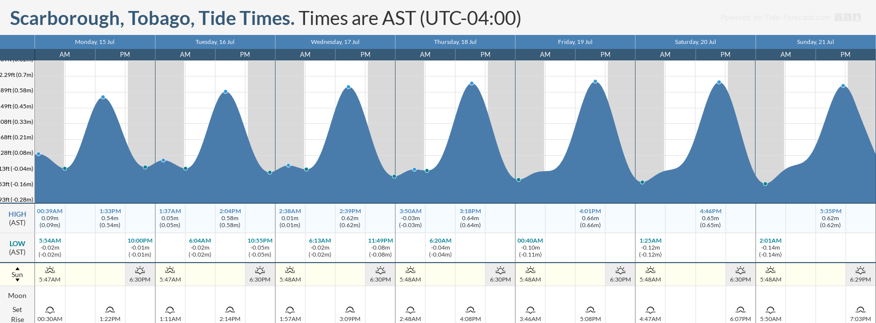
With a full moon expected on July 21st, spring tides are forecast to begin on July 19th, requiring caution from mariners.
Latest Alerts

High Wind Alert Remains In Effect For T&T
Trinidad and Tobago is NOT under any tropical storm or hurricane threat, watch, or warning at this time.
Seas Forecast For Trinidad and Tobago
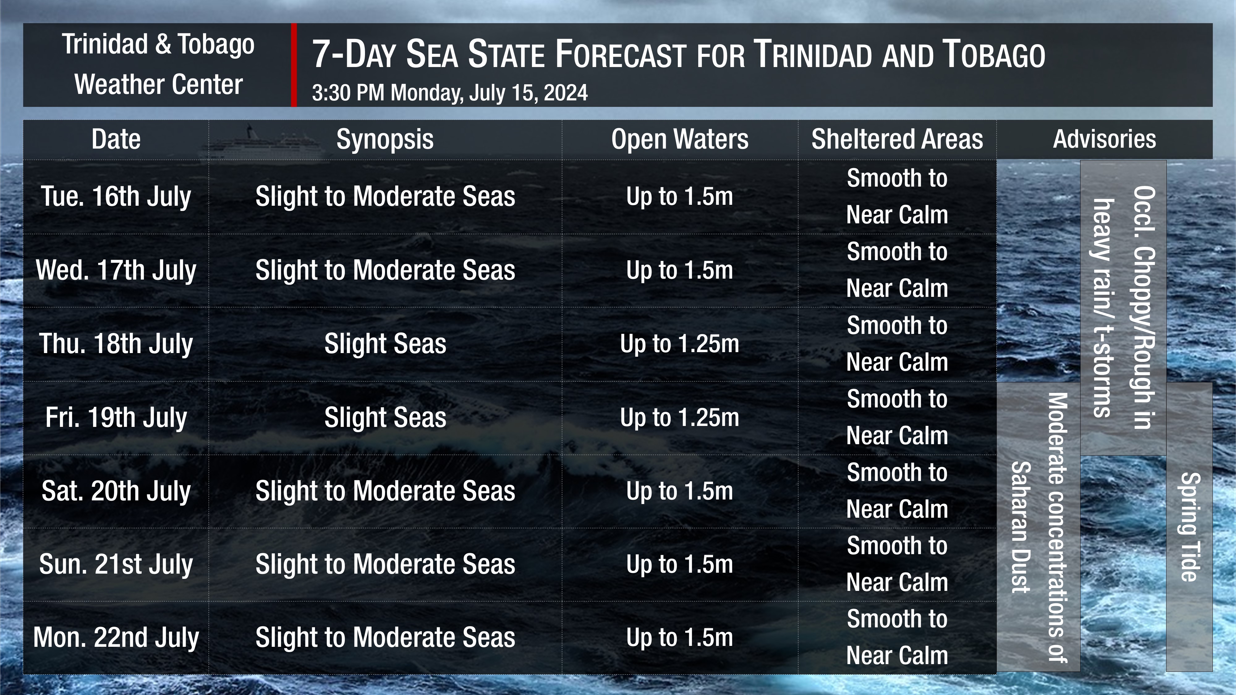
Tuesday through Friday: Seas are forecast to be slight to moderate in open waters, with waves up to 1.5 meters mainly in northeastern areas. In sheltered areas, conditions are forecast to generally be smooth to near calm, with waves less than 0.5 meters. Conditions may become locally rough and/or choppy in the vicinity of heavy showers or thunderstorms. Swell periods are forecast to range between 6 and 9 seconds, with swells from the northeast to southeast. Wind speeds are forecast to range between 0 and 10 knots, occasionally reaching 15 knots on Tuesday evening through Wednesday morning and Friday. Through the four-day period, winds may gust to 20 knots. Wind direction is forecast to be from south to southeast on Tuesday and Wednesday and east to south on Thursday and Friday. Spring Tides to begin on Friday.
Saturday through Monday: Seas are forecast to be slight to moderate in open waters, with waves up to 1.5 meters. In sheltered areas, conditions are forecast to be smooth to near calm, with waves forecast to be less than 0.5 meters. Winds are forecast to be from the east-northeast to southeast between 5 to 10 knots, gusting to 20 knots. Swell periods between 6 and 9 seconds, with swells from the northeast. Spring Tides ongoing.
Possible Impacts
No major marine impacts are forecast over the next seven days. However, mariners should exercise caution during periods of inclement weather, as seas may become locally rough or choppy in the vicinity of heavy showers and thunderstorms, particularly due to gusty winds.
Due to the Intertropical Convergence Zone remaining across the country this week, winds are forecast to be light to near calm and variable, with southeasterly to southerly winds possible on Tuesday through Friday. This may also lead to agitated seas in the Gulf of Paria and larger-than-usual waves along south-facing coastlines as heavy showers and thunderstorms move south to north.
Spring Tides, which are higher-than-usual high tides and lower-than-usual low tides, are forecast to begin on July 19th. All marine interests are advised to exercise caution, particularly during high tide periods.
Lastly, Saharan Dust levels are forecast to increase from July 20th, leading to increasingly hazy skies and marginally decreased horizontal visibility, particularly near dust and dawn.
Rip currents always pose a hazard on the nation’s beaches. If caught in a rip current, swim perpendicular to the current (parallel to the shore). Mariners, especially small craft operators, should ensure their vessels are securely anchored or docked, as choppy/breaking wave conditions may drag the vessel onto the ocean floor or reefs in shallow waters or even break anchorage/mooring.


