


The 2024 Wet Season is forecast to have near-normal to above-normal rainfall overall, but the Trinidad and Tobago Meteorological Service (TTMS) reports that several communities are under an elevated threat of flooding.
This is the third year the organization has issued flood guidance within their “Flood Potential Outlook” as part of their overall Wet Season climate outlook.
They are forecasting accumulated rainfall totals above 1,000 millimeters across the Leeward side of Tobago and areas of the southwestern coast of Trinidad over the next six months. Higher rainfall accumulations near 2,560 millimeters in northeast Trinidad, in the vicinity of Sangre Grande, Vega De Oropouche, Plum Mitan, and environs, are also forecast. In Tobago, areas near Mt. St. George and Goodwood are forecast to receive nearly 2,000 millimeters of rainfall from June through December.
In their 2024 Wet Season Flood Potential Outlook, the TTMS states, “Flood potential is moderately higher than normal across other well-known flood-prone areas in northeast, northwest, and southern Trinidad and Tobago.” Meanwhile, central-west and southeast Trinidad have slightly higher than normal flood potential, according to the TTMS.
This year, in keeping with the trend from 2023, there were no high-risk communities like in 2022, but there was a significant increase in moderate-risk areas.
Moderate Flood Risk Potential – 152 Communities

Based on the Met Office’s analysis, the following communities have a moderately higher than normal flood potential in Trinidad:
- De Gannes Village
- Penal Quinam Beach Road
- Robert Hill/Siparia
- Siparia
- Syne Village
- Dow Village
- Harris Village
- Mon Desir
- Oropouche
- Pepper Village
- St. John
- Debe Proper
- Basse Terre
- La Lune
- Marac
- Penal
- Penal Rock Road
- Barrackpore
- Pleasantville
- Cocoyea Village
- Green Acres
- Corinth
- Esperance Village
- Palmiste
- Golconda
- St. Clements
- Victoria Village
- Diamond
- Bonne Aventure
- Caratal
- Cedar Hill
- Forres Park
- Gasparillo
- Hermitage
- Macaulay
- Parforce
- Plaisance Park
- Springland/San Fabian
- St. Margaret
- Sum Sum Hill
- Pointe-a-Pierre
- Union Village
- Oropune Village/Piarco
- La Horquetta
- San Raphael/Brazil
- Talparo
- Las Lomas (#1 & #2)
- Madras Settlement
- Cocal Estate/Mayaro
- Fishing Pond
- North Manzanilla
- Oropouche
- Cumuto
- Plum Mitan
- Cunupia
- Biche
- Kelly Village
- Manzanilla
- Sangre Chiquito
- Sangre Grande
- St. Helena Village
- Valencia
- Arouca
- Longdenville
- Endeavour Village
- Tunapuna
- St. Augustine
- St. Augustine South
- El Socorro
- El Socorro Extension
- Aranguez
- Bamboo Grove
- Morvant
- Newtown
- Sea Lots
- St. Clair
- St. James
- Woodbrook
- East Port of Spain
- Port of Spain Proper
- Port of Spain Port Area
- Big Yard
- La Horquetta
- Point Cumana
- La Puerta
- West Moorings
- Simeon Road
- Diego Martin Proper
- Rich Plain
- Industrial Estate
- Diamond Vale
- Covigne
- Glencoe
- Bayshore
- Victoria Gardens
- Alyce Glen
- Four Roads
- Bagatelle
- Blue Basin
- St. Lucien Road
- Blue Range
- Goodwood Gardens
- Green Hill Village
- Patna Village
- River Estate
- North Post
- Maraval Proper
- Toco

In Tobago, the TTMS pinpointed 44 communities that have a moderately higher-than-normal potential for flooding:
- Arnos Vale
- Les Coteaux
- Bethesda
- Plymouth
- Mary’s Hill
- Whim
- Mount Grace
- Cinnamon Hall/Gov’t House
- Idlewild/Whim
- Darrel Spring
- Mount Marie
- Patience Hill
- Sargeant Cain
- Carnbee/Patience Hill
- Calder Hall/Friendsfield
- Bethel/Mt. Gomery
- Bagatelle
- Signal Hill/Patience Hill
- Scarborough
- Spring Garden/Signal Hill
- Sherwood Park
- Lambeau
- Black Rock
- Mt. Irvine/Black Rock
- Orange Hill
- Buccoo/Coral Gardens
- Old Grange/Sou Sou Lands
- Bethlehem
- Bethel
- Milford Court/Pigeon Pt.
- Canaan
- Lowlands
- Crown Point
- Bon Accord
- Mount Pleasant
- Carnbee/All Field Trace
- Hope/Blenheim
- Zion Hill
- Belle Gardens
- Betsy’s Hope
- Delaford/Louis D’or Lands
- Speyside
- Charlotteville
- Campbleton/Charlotteville
Slight Flood Risk Potential – 29 Communities

Based on the Met Office’s analysis, the following 29 communities have a slightly higher than normal flood potential in Trinidad:
- Bamboo Village
- St. Mary’s Village
- Sixth Company
- Fifth Company
- Indian Walk
- St. Mary’s Village
- Bon Jean
- La Ruffin
- La Savanne
- Moruga Village
- Brasso Caparo Village
- Calcutta Road #2
- Chickland
- Gran Couva
- Preysal
- Spring Village
- Arena
- Freeport
- Caparo
- Couva Central
- St. Mary’s Village
- Fairview
- Enterprise
- Lendore Village
- Edinburgh 500
- Lange Park
- Chaguanas Proper
- Montrose Village
- Mayaro
In Tobago, the TTMS highlighted no communities that had a slightly higher-than-normal potential for flooding.
Comparing 2023 to 2022’s Flood Potential Outlook
In 2023, the TTMS introduced the near-normal category, which captured a substantial number of communities. No communities were placed under a high risk of flooding or “much higher than normal.” In 2024, only slight and moderately higher than usual flood potential was highlighted.
Last year, 126 communities were highlighted for their above-normal potential for flooding. This year, that total stands at 181. For comparison, in 2022, 81 communities were highlighted for their above-normal potential for flooding.
Compared to 2023, 2024 highlights the same communities for an elevated flood threat but at a generally higher risk level.
When can we expect to see most floods?
When the TTMS assesses the flood potential for the country rather than individual communities, it looks at the potential for monthly rainfall exceeding 250 millimeters, 24-hour rainfall exceeding 25 millimeters (a heavy rainfall day), and three—and five-day wet spells (days where T&T records consecutive rainfall equal to or more than 10 millimeters).

June is forecast to kick off a wetter-than-usual start to the 2024 Wet Season. According to the TTMS, there is a high chance for most of Trinidad to exceed 250 millimeters of rainfall (the monthly threshold for flooding), particularly in eastern areas, for June 2024, which increases the potential for flood events in those areas. Officially, across both islands, there is a 13% to 93% chance of rainfall exceeding 250 millimeters in June 2024.

August is Trinidad’s wettest month, climatologically. According to the TTMS, the chances of rainfall exceeding 250 millimeters are also high across the eastern half of Trinidad, particularly across northeastern Trinidad. The TTMS says that across both islands, there is a 10% to 82% chance of rainfall exceeding 250 millimeters during August 2024.
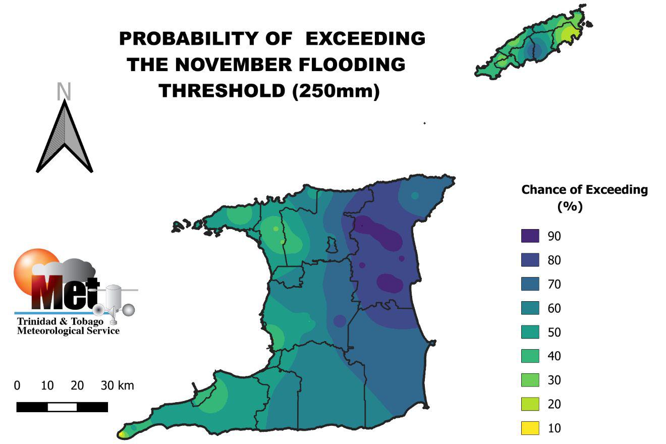
November, the secondary peak of the local Wet Season, also has a high chance of exceeding monthly rainfall accumulations of 250 millimeters, particularly across northeastern areas of Trinidad.
Overall, the TTMS says there is a 52% chance of an above-normal number of heavy rainfall days (where T&T receives above 25 millimeters of rainfall), with the likely range of heavy rainfall days between June and December between 11 and 22. The average number of heavy rainfall days is 16.
However, when looking at extreme or extremely heavy rainfall days (where T&T receives upwards of 50 millimeters of rainfall), there is a 43% chance of 2 to 6 extremely heavy rainfall days, compared to the normal four days. According to the TTMS, there are at least five days where daily rainfall accumulations could exceed 75 millimeters.
Isolated heavy rainfall or extremely heavy rainfall days can be temporarily disruptive, but for longer-lasting riverine flooding to occur, rainfall will need to persist over several days. For 2024, the TTMS is forecasting a 53% chance of above-normal three-day wet spells, where they expect 5 three-day wet spells compared to the normal of 4 three-day wet spells. The TTMS says the 2024 Wet Season is likely to have 49 wet days, where T&T records 10 millimeters of rainfall or more, compared to the normal 47 wet days.
For those wary of prolonged flooding, the TTMS is also forecasting a 73% chance of one five-day wet spell – or five consecutive days where T&T records at least 10 millimeters of rainfall. Between 1991 and 2020, on average, the Wet Season has one five-day wet spell period.
Ultimately, with another “volatile and erratic” Wet Season forecast, everyone is being urged to accelerate preparations from now, particularly if you live in flood prone areas, whether that is street, flash, or riverine flooding.


