


As swells gradually subside into the weekend, low-level winds are forecast to increase. As a result, open waters are forecast to become agitated, but wave heights are expected to remain below hazardous levels. Still, marine interests are advised to exercise caution.
Latest Alerts

TTMS Issues Adverse Weather Alert For T&T
Trinidad and Tobago is NOT under any tropical storm or hurricane threat, watch, or warning at this time.
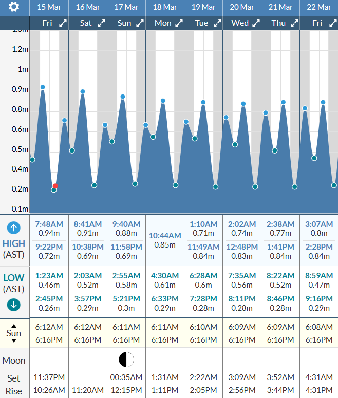
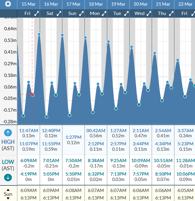
Seas Forecast For Trinidad and Tobago

Saturday through Tuesday: Seas are forecast to be moderate open waters, with waves generally between 1.5 and 2.0 meters. Particularly in eastern and northeastern waters, open water waves as high as 2.5 meters are forecast. In sheltered areas, waves are forecast to be below 1.5 meters and with choppy conditions. Swell periods are forecast to range between 9 and 12 seconds, with longer-period swells taking a brief hiatus on Monday and returning by Tuesday. Winds are forecast to be near 20 knots from the east-northeast to east-southeast, with gusts up to 30 knots. Peak winds are forecast on Sunday into Monday, subsiding by Tuesday.
Wednesday through Friday: Seas are forecast to be moderate in open waters, with waves between 1.5 and 2.0 meters. In sheltered areas, waves are forecast to be near 1.0 meter. Swell periods are forecast to range between 8 and 12 seconds. Winds are forecast to range between 10 and 20 knots from the northeast to east-southeast, gusting to 25 knots. Lighter winds are forecast on Friday.
Possible Impacts
Through the forecast period, the main hazards will result from elevated winds leading to agitated offshore conditions and occasionally choppy conditions in sheltered areas. Marine interests along northern coastlines will still need to exercise caution due to occasional long-period swells through Tuesday.
Elevated winds, mainly from Saturday through Tuesday morning, may create hazardous conditions for small craft operators, particularly those in northeastern and eastern coastal areas. Large, open-water swells (up to 8 feet/2.4 meters) can be hazardous to some vessels, and smaller craft operations can be difficult during this time. In nearshore areas, northerly swells will also pose a hazard for mariners and beachgoers.
There will be an elevated risk of rip currents through the forecast period, particularly along northern coastlines. If caught in a rip current, swim perpendicular to the current (parallel to the shore). Mariners, especially small craft operators, should ensure their vessels are securely anchored or docked as choppy/breaking wave conditions may drag the vessel onto the ocean floor or reefs in shallow waters or even break anchorage/mooring.
Saharan Dust concentrations are forecast to increase over the weekend and during the first half of the week, leading to some decrease in horizontal visibility, particularly during dawn and dusk.


