


Trinidad recorded a whopping 34.7°C at Piarco on Sunday, 27th August 2023, marking the hottest temperature at the island’s official climate reference site since October 18th, 2020, when thermometers recorded a maximum high of 35.5°C.
This maximum high temperature has been part of an unrelenting period of excessive heat across the country over the last several days, where the hottest temperature for the year to date has been broken nearly every successive day.
While the country’s maximum high temperature hasn’t officially met the definition of a hot spell (what we call a heat wave) yet, dangerous heat is forecast to continue for at least one more day before some relief arrives on Tuesday, with the passage of a Tropical Wave interacting with the Intertropical Convergence Zone across T&T.
What’s causing the heat?
Over the last week, the remnants of Tropical Storm Gert lingered east of the Leeward Islands, leading to light southerly winds, to near calm at times, with high levels of atmospheric moisture leading to warm air remaining near the surface, while at night, mid/upper-level clouds prevent the escape of heat into the atmosphere. The result is warm, humid nights and hot, humid days across not only Trinidad and Tobago but the remainder of the Lesser Antilles.
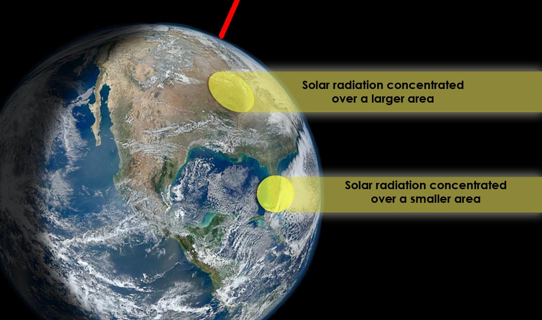
On a larger scale, the solar altitude, or the angle of the sun relative to the Earth’s horizon, is at 90° across T&T (occurred on August 25th). When this occurs, solar radiation is concentrated over a smaller surface area, causing warmer temperatures.
T&T’s Temperatures
August 24th, 2023

On Thursday, thermometers at Piarco recorded 33.8°C, breaking the August 7th record for then, the hottest day for the year, at Trinidad’s climate reference site, while at Crown Point, Tobago, the maximum high was a quite humid 31.8°C.
However, minimum lows were far more substantial when looking at T&T’s climate record. Today was the warmest morning of the year so far, with minimum lows at Piarco and Crown Point coming in at 27.2°C and 28.7°C respectively, well above the long-term averages of 24.0°C for Piarco and 24.9°C for Crown Point. These departures from average were so high they rank as the 3rd warmest (tied with yesterday, August 23rd) minimum low temperature for Piarco and the 2nd warmest for Crown Point on record.
Across most of the country, temperatures ranged between 34.0°C and 37.0°C, mainly across Trinidad. Increased cloud cover across northern Trinidad and western Tobago kept the temperatures marginally cooler. In urban areas and areas where development is prevalent, temperatures trended higher.
With abundant moisture present at the lowest levels of the atmosphere, the heat indices, or what the outside feels like, remained high, in the “Dangerous” category across much of Trinidad and Tobago. The heat index is a combination of air temperature and relative humidity, determining what the air feels like to a person, i.e., how hot it actually feels. The heat index is important because of sweating. Your body sweats to cool the skin and maintain a constant, healthy body temperature.

August 25th, 2023

Twenty-four hours later, Piarco broke the August 24th record for the hottest day of the year in Trinidad again, with temperatures above 34°C for the first time for 2023 to date at that point, coming in at 34.2°C while at Crown Point – Tobago’s climate reference site – the maximum high was 32.3°C on Friday, August 25th, 2023.
Much of the country had sweltering temperatures, with several weather stations across central Trinidad recording its hottest temperatures for 2023 to date, between 34°C and 38°C. During the afternoon, a strong thunderstorm developed across west-central Trinidad and moved north, leading to a significant drop in afternoon temperatures, between 6°C and 12°C. Torrential rainfall also led to flooding across parts of Mamoral, Oropune, and Tunapuna.
The heat index was solidly in the “Dangerous” category for another day across most areas of Trinidad on Friday.

August 26th, 2023

While not record-breaking at Piarco nor Crown Point, maximum high temperatures remained warm at both sites, coming in at 33.6°C and 31.9°C respectively.
Elsewhere across the country, maximum high temperatures ranged from 33°C to 37°C in most areas, trending marginally cooler across northwestern Trinidad as a result of some increased afternoon cloud cover.
However, compared to the past two days, the heat index rose at several sites on Saturday, August 26th, 2023, and while the feels-like temperature was still in the “Dangerous” category, the hottest day was yet to come.

August 27th, 2023

Piarco recorded its hottest day for 2023 (again, to date) on Sunday, August 27th, 2023, with a maximum high of 34.7°C. Unlike Friday and Saturday, no afternoon, heat-driven thunderstorms developed across parts of Trinidad to quell the heat, leading to multiple weather stations across southern, central, and northern Trinidad recording its highest heat indices for the year to date as well.
At Crown Point, the maximum high temperature came in at 32.6°C but the minimum low temperature on Sunday morning was the second warmest for the year, at 28.6°C and the 3rd highest minimum low recorded at the climate reference site since 1976.
Maximum high temperatures, like the past three days, ranged between 33°C and 37°C while the heat indices generally remained above 41°C, with multiple sites between 47°C and 51°C.

T&T’s Dangerous Heat Indices

As indicated above, nearly all weather stations across the country recorded heat indices for the past four days in the dangerous category.
When the heat index is at this level, heat cramps and heat exhaustion are likely, while heat stroke is probable with continued activity.
With at least one more hot day forecast, where dangerous heat indices are forecast, it is important to take action to prevent unwanted consequences:
- Stay cool by drinking lots of water. Avoid drinks with caffeine and alcohol.
- Wear loose-fitting, lightweight, light-colored clothing.
- Avoid strenuous exercise during the hottest times of the day, between 10:00 AM and 3:00 PM.
- Take frequent breaks while working outdoors.
- During hot weather, remember to check on family, friends, and neighbors who do not have air conditioning, as very high temperatures may be dangerous to their health.
- Use the night air to cool your home by opening all windows during the night and early in the morning.
- During the day, close windows and shutters which are facing the sun.
- Avoid going outdoors during the hottest time of the day. Stay out of the heat. When possible, stay indoors or in shaded areas.
- If possible, stay in air-conditioned buildings as much as you can.
- Wear sunscreen, especially if you are working outdoors.
Hot Temperatures For One More Day
Across both islands, hot conditions are forecast over the next several days. On Tuesday, the Intertropical Convergence Zone, interacting with the passage of a tropical wave, is forecast to produce showers, isolated thunderstorms, and cloudy skies, bringing some much-needed heat relief to the country. While hot and dry conditions are likely to return for the remainder of the week.
Monday
Low: 25-28°C
High: 32-37°C
Tuesday
Low: 24-27°C
High: 29-32°C
Wednesday
Low: 24-26°C
High: 31-35°C
Thursday
Low: 24-28°C
High: 32-37°C
Friday
Low: 24-28°C
High: 32-37°C
Temperatures in cities, such as Port of Spain, tend to be much higher than in surrounding locations due to a phenomenon called the Urban Heat Island Effect. There are several causes, but the main instigator for this phenomenon tends to be increased dark surfaces, such as roads and pavement in cities, which absorb solar radiation more than surrounding areas.
On Monday, the heat index is forecast to remain at dangerous levels, dropping to levels that require extreme caution and, at times, dangerous for the remainder of the week, even with increased cloud cover. For Monday and after Wednesday, across Trinidad, the maximum heat index is forecast to be between 38°C and 50°C and even higher in urbanized areas. In Tobago, the maximum heat index is forecast to be between 40°C and 45°C.
Is this a heatwave?
Not yet.
For Monday, the maximum high at Piarco is forecast to reach above 34.0°C and near 33.0°C at Crown Point. While this will meet the criteria for a hot day, temperatures at these levels need to persist for a longer period. With marginally cooler temperatures forecast this week, it is unlikely we will hit the official definition.
For a hot spell to be declared in Trinidad and Tobago by the Trinidad and Tobago Meteorological Service, a period of hot temperatures, characterized by maximum temperatures of at least 34.0°C in Trinidad and 33.0°C* in Tobago, lasting five or more consecutive days. A short-duration hot spell is three or more consecutive hot days.
*The threshold for a hot spell at Crown Point was increased in August 2023 by the Trinidad and Tobago Meteorological Service. Hot spell temperatures are supposed to characterize the hottest temperatures (within the 95th and above percentiles of temperatures). According to the TTMS, the prior threshold was too low.
Where do these temperatures stand compared to our records? The hottest recorded temperature for August in Trinidad, according to the Trinidad and Tobago Meteorological Service (1946-2022), stands at 35.8°C recorded on August 23rd, 2017, while at Crown Point, Tobago, the maximum high was 34.2°C recorded on August 28th, 2008. At Piarco International Airport, the hottest temperature ever was recorded on September 25th, 1990, at 36.5°C.


