


Saharan Dust levels are on the decline across Trinidad and Tobago as the Intertropical Convergence Zone/Monsoon Trough lifts north. Over the next ten days, while brief surges are forecast, no high-concentration Saharan Dust plumes are forecast to reach T&T, but for the Leewards, moderate to occasionally high dust concentrations are forecast to linger.
What you need to know
— Saharan Dust Surges: A brief Saharan Dust surge is forecast to move across T&T by late Monday through late Tuesday, August 21st through 22nd. Another surge is forecast from August 25th, but higher dust concentrations are forecast to remain north of T&T.
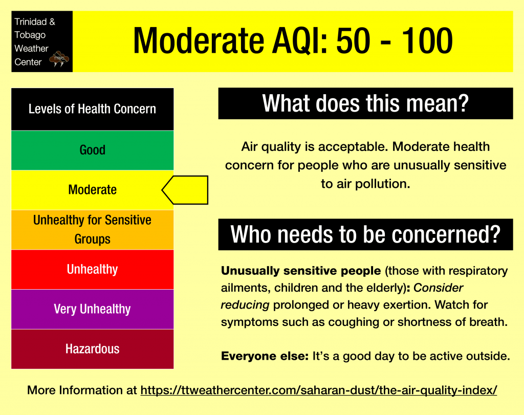
— Impacts: Through the next seven to ten days, air quality levels across Trinidad and Tobago are forecast to remain between good and moderate.
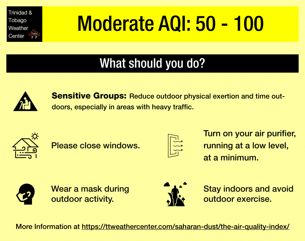
— What Should You Do: Sensitive groups will be required to take the necessary precautions through late Saturday, between August 21st and 22nd, and again from August 25th.
Current AQI Levels Across T&T
The official air quality monitoring stations from the Environmental Management Agency (EMA) at Point Lisas and Arima are reporting good quality levels while San Fernando is reporting good air quality. Stations at Beetham and Signal Hill, Tobago, are not reporting PM2.5 or PM10 data as of Thursday evening.
These measurements are based on PM2.5 (particulates the size of 2.5 micrometers and smaller, usually associated with increases in Saharan Dust, vehicle exhaust, and smoke) and PM10 particulates.
Over the last 24 hours, visibility remained unaffected by Saharan Dust and smoke at the A.N.R. Robinson International Airport at Crown Point, Tobago, and at the Piarco International Airport, Trinidad.
Saharan Dust Forecast
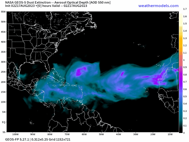
Saharan Dust levels are on the decline across Trinidad and Tobago, with little to no dust forecast by late Saturday, August 19th, 2023.
A brief surge of dust is forecast to arrive across T&T by late Monday, August 21st, 2023, with improvement by Wednesday, August 23rd, 2023. Mild to moderate concentrations are forecast, with higher dust levels north of the country.
Another surge of dust is forecast by August 25th during the early morning hours, and this dust is forecast to linger through the end of the forecast period (August 27th). Concentrations with this surge are also expected to be at mild to moderate concentrations, with higher dust levels remaining across the Leewards.
Through the second half of August, an amplified Intertropical Convergence Zone/Monsoon Trough, combined with possible tropical cyclones and higher-latitude tropical waves are forecast to keep Saharan Dust north of the country, with less robust plumes leaving Western Africa.
What does this mean for you?
We’re in a period where the Intertropical Convergence Zone and tropical waves and occasional tropical cyclones may shield Trinidad and Tobago from the Saharan Dust events. While Tropical Waves play a notable role in moving dust across the Atlantic and the Eastern Caribbean, these periodic tropical waves also improve air quality.
The concentration of the dust that follows the wave depends on its strength as it moves off the West African Coast. This is because of stronger thunderstorms across Central Africa. As strong winds move downward and outward from these thunderstorms, the wind kicks up dust as it moves across parts of the Saharan Desert and transports it into the upper atmosphere. This “plume” of dust follows the axis of the wave as it progresses westward into the Atlantic.
Dust that makes it into the upper levels of the atmosphere can then get transported across the Atlantic Ocean. The plumes of dust eventually affect the Eastern Caribbean.
Larger, more concentrated plumes of Saharan dust begin in April and continue through November.


