


Two tropical waves between Trinidad and Tobago and the African Coast are forecast to move across the region in the coming five days, with the closest wave moving across the country on Saturday, July 1st, 2023. As we head through July, tropical waves are forecast to remain periodic, moving across T&T every five to seven days.
Meanwhile, in the North Atlantic, the National Hurricane Center is monitoring a surface trough with low chances of tropical cyclone formation.
What you need to know
— Tropical Wave 18: The axis of this tropical wave is located between 50W and 52W, moving west at 10 to 15 knots (18-27 KM/H). This wave is forecast to move across T&T and the Windwards on Saturday, July 1st, 2023, bringing the ITCZ across the country.
— Tropical Wave 19: The axis of this tropical wave is located at 24W, moving west at 15 knots (27 KM/H). This wave is forecast to move across T&T and the Windwards on Monday, July 3rd, into Tuesday, July 4th, 2023, bringing the ITCZ across the country.
— North Atlantic AOI: The NHC is monitoring a surface trough in the North Atlantic Ocean with low chances of tropical cyclone formation. It poses no threat to T&T and the Lesser Antilles.
— Hazards: For Trinidad and Tobago, scattered showers, periods of rain, and thunderstorms are all forecast, mainly from late Friday through Saturday, and again from Monday morning through Tuesday night. Street/flash flooding, landslides, and gusty winds are likely. Through Saturday, total rainfall accumulations are not forecast to be extreme, likely due to the concentrations of Saharan Dust that are forecast to be present. Next week, however, significant rainfall is possible Monday into Tuesday. See the forecast for more information.
— Development Concerns: Elsewhere across the Atlantic, tropical cyclone development is not expected, according to the National Hurricane Center.
Tropical Wave 18
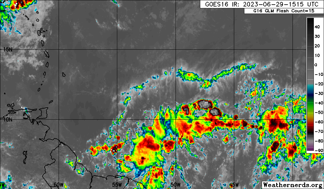
The 18th tropical wave for the 2023 Atlantic Hurricane season was analyzed between 50W and 52W, moving west at 10 to 15 knots (18-27 KM/H).
On Thursday afternoon, wind shear across the wave was moderate, with abundant, deep tropical moisture present. The wave was located in a favorable upper-level environment that is forecast to move west along with the wave axis across Trinidad and Tobago.
As this wave moves west on Saturday, the atmosphere is forecast to remain very moist with relative humidity values above 80%, with near-saturated air at mid to upper levels, resulting in abundant cloudiness. In addition, forecast models indicate moderate instability across Trinidad and Tobago on Saturday, with conditions generally favorable for heavy showers and isolated to scattered thunderstorms.
In addition, the Intertropical Convergence Zone is forecast to be pulled northward and across the country on Saturday. As a result, peak inclement weather associated with this wave will occur generally during the pre-dawn and early afternoon hours.

Tropical Wave 19
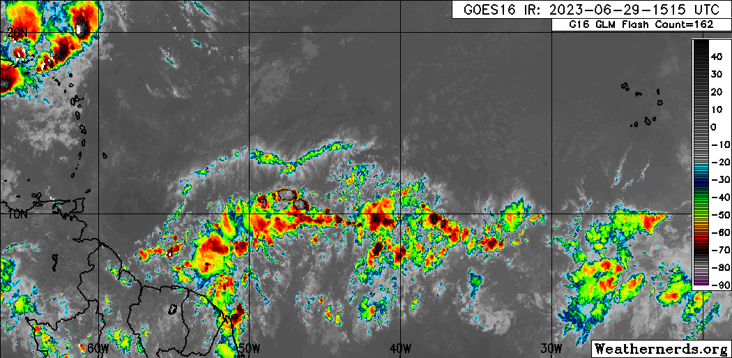
The 19th tropical wave for 2023 has left the African coast with scattered weak convection both ahead and trailing the wave axis. As of 5:00 PM Thursday, the axis of this tropical wave is located along 24W, moving west at 15 knots (27 KM/H).
This tropical wave is forecast to move across the Atlantic over the next several days and begin to affect the Windward Islands from late Monday, July 3rd, 2023. Forecast models indicate this wave being particularly strong and well-defined, with relatively strong low-level winds accompanying the wave from early Monday. As a result, Trinidad and Tobago is forecast to experience periods of inclement weather during the second half of Monday through Tuesday, with periods of heavy rain, thunderstorms, and gusty winds. See the forecast for more information.
Area of Interest

The National Hurricane Center (NHC) is monitoring a surface trough that continues to produce disorganized showers and thunderstorms a few hundred miles to the south-southeast of Bermuda. In their 2:00 PM Thursday Tropical Weather Outlook, they state that upper-level winds do not appear conducive for the development of this system during the next couple of days while it moves generally northward at 5 to 10 MPH.
Not Every Tropical Wave Brings Severe Weather
Tropical waves vary in intensity as it travels westward across the Atlantic. This variability can be on the order of days to as short term as hours. Sometimes, you may see satellite imagery that shows heavy thunderstorms and deep convective activity east of Trinidad and Tobago during the late night and early morning, but by daybreak – nothing.
This is due to diurnal (daily) variations in convective showers whereby convection peaks overnight and wanes during the day for already occurring convective systems (i.e., not triggered by daytime heating).
Activity can be enhanced by its proximity to upper-level troughs and the ITCZ but can also be degraded by hostile upper-level conditions and Saharan Dust.


