


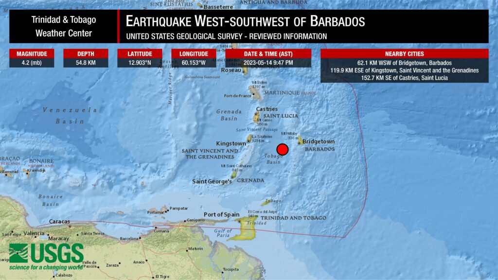
At 9:47 PM on Sunday, May 14th, 2023, the University of the West Indies Seismic Research Centre (UWI SRC) recorded a light magnitude 4.3 (mt) earthquake.
The UWI SRC has preliminarily located the quake at 60.230°W and 12.960°N, approximately 70 kilometers west-southwest of Bridgetown, Barbados, 113 kilometers east-southeast of Kingstown, Saint Vincent and the Grenadines, and 145 kilometers southeast of Castries, Saint Lucia. The event was located at a depth of 10 kilometers.

The UWI SRC is the authority for seismic and volcanological information in the English-speaking Eastern Caribbean. Changes in earthquake magnitude, depth, and location are not unusual when the quake is reviewed by an analyst at the UWI SRC.
The event was not reported felt based on felt reports at this time. You can submit felt reports to the University of the West Indies Seismic Research Centre.
There was no tsunami threat.
There are four conditions necessary for an earthquake to cause a tsunami:
- The earthquake must occur beneath the ocean or cause material to slide within or into the ocean.
- The earthquake must be strong, with at least a magnitude of 6.5.
- The earthquake must rupture the Earth’s surface and it must occur at a shallow depth – less than 70 kilometers below the surface of the Earth.
- The earthquake must cause vertical movement of the seafloor (up to several meters).
None of these conditions occurred.
Note that different seismic monitoring agencies use different methods, or several methods, for processing quake parameters across the globe. Each method has its limitations and will likely produce different results within the range of the data’s uncertainty. This is generally accepted within the scientific community.
The United States Geological Survey (USGS) recorded this quake at a magnitude of 4.2 (mb) at a depth of 54.8 kilometers in a similar location to the UWI SRC.
Read More

Earthquake Magnitude & Intensity

Can earthquakes be predicted or forecasted?
Where this particular earthquake occurred, within 20 kilometers of the new UWI SRC epicenter, only 20 earthquakes have been located within this area since 1987, with the strongest quake, outside of Sunday night’s event, coming in at magnitude 3.8 on April 4th, 2015. Most quakes in this area occur between magnitudes 2.0 and 3.5 at depths shallower than 60 kilometers.
Has there been an increase in seismic activity?
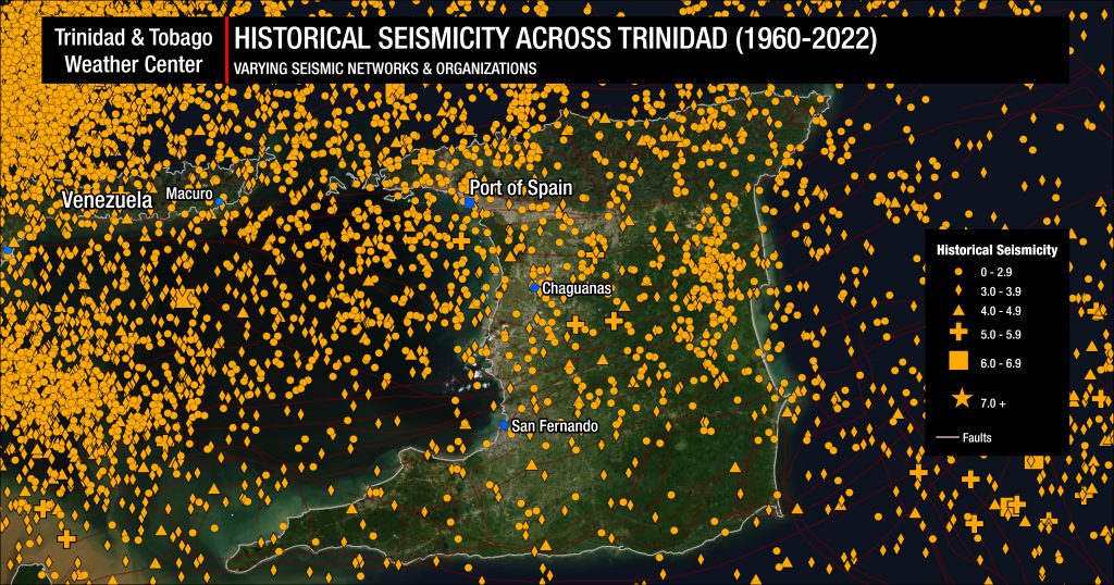
Trinidad and Tobago and the surrounding region are very seismically active. Across the Eastern Caribbean, over 2,200 earthquakes are recorded annually. Since 1990, the University of the West Indies Seismic Research Centre records an annual average of 280 earthquakes in the Trinidad and Tobago region (area bounded by 9.5°- 11.5°N & 59.5°W – 63.5°W). Of these 280 quakes, 50 of these seismic events are, on average, above magnitude 3.5.
Most earthquakes occur northwest of Trinidad in an area known as North of the Paria Peninsula, which has the second-highest seismicity in the Eastern Caribbean. According to the UWI SRC, approximately 65 events of magnitude 2.1 and above are located in the area annually.
However, the UWI SRC has said regional seismic and volcanic activity has been elevated for several years in their annual report for 2020 to 2021.
On average, the Eastern Caribbean has seen a pattern of major (M7.0-M7.9) quakes every 20 to 30 years. That pattern has stayed true. The last major (M7.0-7.9) quake occurred north of Martinique in 2007.
Historical patterns indicate that great quakes (M8.0+) on the Richter Scale have occurred every century in the region. The probability of another event at that level is high since the last >M8.0 earthquake occurred in 1843. While it is impossible to say definitively when the next great quake would occur in the region, the time since the last one is now more than 170 years ago.
It is important to note seismic activity *cannot* be predicted – meaning the precise time, date, magnitude, depth, etc., cannot be known ahead of time based on current research and technology.
Now is the time to create or go over your earthquake preparedness plan and know what to do during, before, and after an earthquake.
Read More

In our region, earthquakes can strike at any time and any place, so it is important to know how to keep yourself safe when one strikes.


