


Seas are forecast to generally moderate across Trinidad and Tobago through the next five days, becoming slight by Friday as winds decrease. Through Wednesday, long-period swells are forecast to agitate seas, particularly in sheltered and nearshore areas of T&T’s northern and eastern coastlines
There are no marine alerts, watches, or warnings from the Trinidad and Tobago Meteorological Service for Trinidad and Tobago at this time.
Latest Alerts

Flooding Continues To Subside As Riverine Flood Alert Discontinued

Adverse Weather Alert Remains In Effect For T&T Through 2 PM Today.
Seas Forecast For Trinidad and Tobago
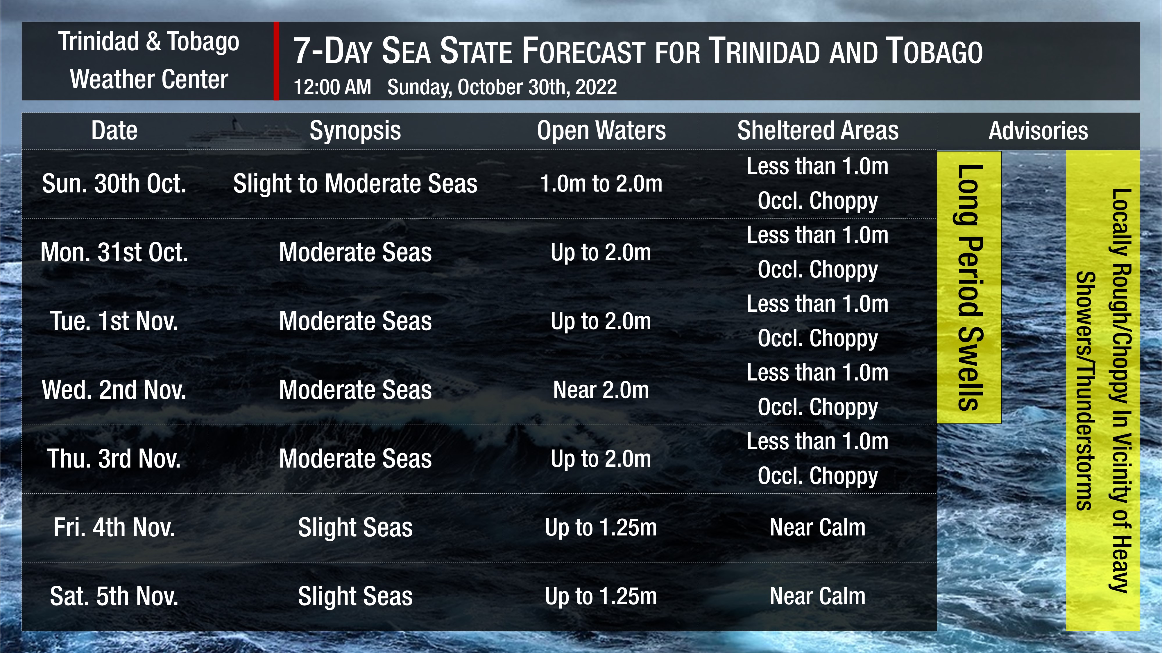
Through the next five days, as low-level winds remain elevated, seas in open waters become moderate, with waves reaching as high as 2.0 meters but remaining less than 1.0 meter in sheltered areas with occasionally choppy conditions in heavy showers or thunderstorm activity, mainly in the Gulf of Paria.
Additionally, through Wednesday, swell periods are forecast to be between 8 and 13 seconds, peaking as high as 15-second swell periods on Sunday (today). These long-period swells (> 11-second period) are forecast to cause larger than usual waves, particularly along northern coastlines. Swells are forecast to return to moderate by late Wednesday, with periods between 6 to 9 seconds through the end of the week.
Winds are forecast to be moderate through the first half of Thursday, with sustained winds between 10 to 20 knots from the southeast to the northeast. Gusts may occasionally reach 30 knots in the vicinity of heavy showers or thunderstorms, particularly Sunday through Monday. Light air to light winds are forecast from Friday onward, with sustained winds up to 10 knots.
Possible Impacts
No significant Saharan Dust is forecast across Trinidad and Tobago over the next week, marginally reducing visibility and air quality.
Through Wednesday, long-period swells are forecast. Swells with longer periods produce larger waves along the coastline, which can be battering and cause the following:
- Loss of life;
- Injuries;
- Coastal erosion;
- Localized disruptions of businesses;
- Damage or loss of boats and fishing equipment;
- Disruptions to marine recreation and businesses
- Economic losses.
The presence of higher energy waves due to long-period swells will increase the rip current threat through Wednesday. Rip currents are strong currents perpendicular to the shoreline that can carry even the strongest swimmers out to sea.


