


The passage of a tropical wave on Tuesday brought showers and thunderstorms to Trinidad and Tobago, with heavier rainfall remaining east and north of the country. Conditions are forecast to settle gradually by Thursday.
What you need to know
— Rainfall: Isolated to scattered showers and isolated thunderstorms are possible on Wednesday, with isolated activity from Thursday through Sunday. Overall rainfall accumulations through the next five days are forecast to be between 25 and 50 millimeters, with isolated totals up to 75 millimeters favoring eastern and northwestern Trinidad.
— Hazards: Street/flash flooding and localized ponding are likely, particularly on Wednesday. Wind gusts in excess of 45 KM/H accompanying heavy showers or thunderstorms are possible. Lightning will accompany thunderstorms. Landslides are possible across both islands.
— Alerts/Watches/Warnings: There are no alerts, watches, or warnings in effect for Trinidad and Tobago from the Trinidad and Tobago Meteorological Service. There are no tropical storm or hurricane watches or warnings in effect for T&T at this time.
— Saharan Dust: Dust concentrations are forecast to gradually diminish through the week across Trinidad and Tobago, with higher dust levels north of the country.
The Forecast
Wednesday
WednesdayThursday
ThursdayFriday
FridaySaturday
SaturdaySunday
SundayMarine: Through Sunday, moderate to slight seas are forecast in T&T’s open waters. There is a risk of rip currents along the country’s coastlines through Wednesday due to spring tides and long-period swells.
Temperatures
Wednesday
Low: 24-25°C
High: 31-32°C
While increased cloud cover is forecast to remain present, sunshine is forecast to peak through partly cloudy to mostly cloudy skies. Heat indices (or feels-like temperatures) are forecast to be up to 35°C.
Thursday
Low: 24-25°C
High: 32-34°C
With mostly sunny skies, heat indices (or feels-like temperatures) are forecast to be between 35°C and 45°C. Higher heat indices are possible in urbanized areas like Port of Spain, Chaguanas, and San Fernando.
Friday
Low: 24-25°C
High: 32-34°C
With mostly sunny skies, heat indices (or feels-like temperatures) are forecast to be between 35°C and 45°C. Locally higher heat indices are possible in urbanized areas like Port of Spain, Chaguanas, and San Fernando.
Saturday
Low: 24-25°C
High: 32-34°C
With mostly sunny skies, heat indices (or feels-like temperatures) are forecast to be between 35°C and 45°C. Locally higher heat indices are possible in urbanized areas like Port of Spain, Chaguanas, and San Fernando.
Sunday
Low: 24-25°C
High: 32-34°C
With mostly sunny skies, heat indices (or feels-like temperatures) are forecast to be between 35°C and 45°C. Locally higher heat indices are possible in urbanized areas like Port of Spain, Chaguanas, and San Fernando.
Forecast Impacts
Flooding
FloodingChances for street and flash flooding remain medium to high across Trinidad and Tobago on Wednesday, becoming medium through the next four days. Riverine flooding remains unlikely as overall rainfall totals remain fairly low.
Forecast Rainfall Totals
- Wednesday: Between 10 to 20 millimeters across both islands with isolated totals exceeding 25 millimeters, favoring northern and western Trinidad, as well as Tobago.
- Thursday: Less than 5 millimeters across both islands, with higher rainfall totals possible across southwestern Trinidad.
- Friday: Less than 5 millimeters across both islands with isolated higher totals across southern and eastern areas of Trinidad up to 15 millimeters.
- Saturday: Between 5 and 15 millimeters across the country, with isolated rainfall totals reaching 25 millimeters across northwestern and eastern areas of Trinidad and Tobago.
- Sunday: Less than 10 millimeters of rainfall across both islands, with locally higher totals in thunderstorm activity favoring northwestern Trinidad.
Putting the rainfall forecast into context, rainfall rates in excess of 50 millimeters per hour or areas that receive in excess of 25 millimeters within an hour tend to trigger street flooding across the country or flash flooding in northern Trinidad. For riverine flooding to occur, a large area of the country (not just in highly localized areas of western coastal Trinidad) would have to record upwards of 75 millimeters within 24 hours, and rainfall would have to fall across major rivers’ catchment areas.
Strong Thunderstorms
Strong ThunderstormsThe chances of strong thunderstorms are low. An unstable atmosphere following the passage of a tropical wave remains across Trinidad and Tobago. However, wind shear is forecast to be strong, limiting persisting activity. Upper-level conditions remain somewhat favorable into Wednesday and then again from Sunday, producing localized support for isolated heavy showers or thunderstorms.
Funnel cloud development is possible from Friday due to light and variable low-level winds. If a funnel cloud touches down on a body of water, it becomes a waterspout; if it touches down on land, it becomes a tornado.
Gusty Winds
Gusty WindsPossible impacts include localized wind damage to trees, power lines, and small structures. Light outdoor objects may topple or become airborne such as garbage cans, potted plants, loose galvanize or construction material, and other outdoor furniture. Tents may jump. Older/weaker trees may fall, bringing down utility poles and lines.
Other Hazards
Abundant frequent cloud-to-ground lightning is possible in strong thunderstorm activity.
Although overall rainfall accumulations remain relatively low, saturated soils still have a high risk of landslides, mudslides, and rockfalls across elevated areas of Trinidad and Tobago.
Why I May Not/Will Not See Rainfall?
A frequent complaint is the forecast is wrong because I didn’t experience any rainfall. Scattered showers mean that you, individually, may experience some showers intermittently throughout the day, and there is a higher chance for this activity than isolated activity. Widespread showers mean that nearly all persons and areas may experience rainfall.
Isolated to scattered rainfall is forecast on Wednesday, with isolated rainfall through the remainder of the forecast period.

Forecast Discussion
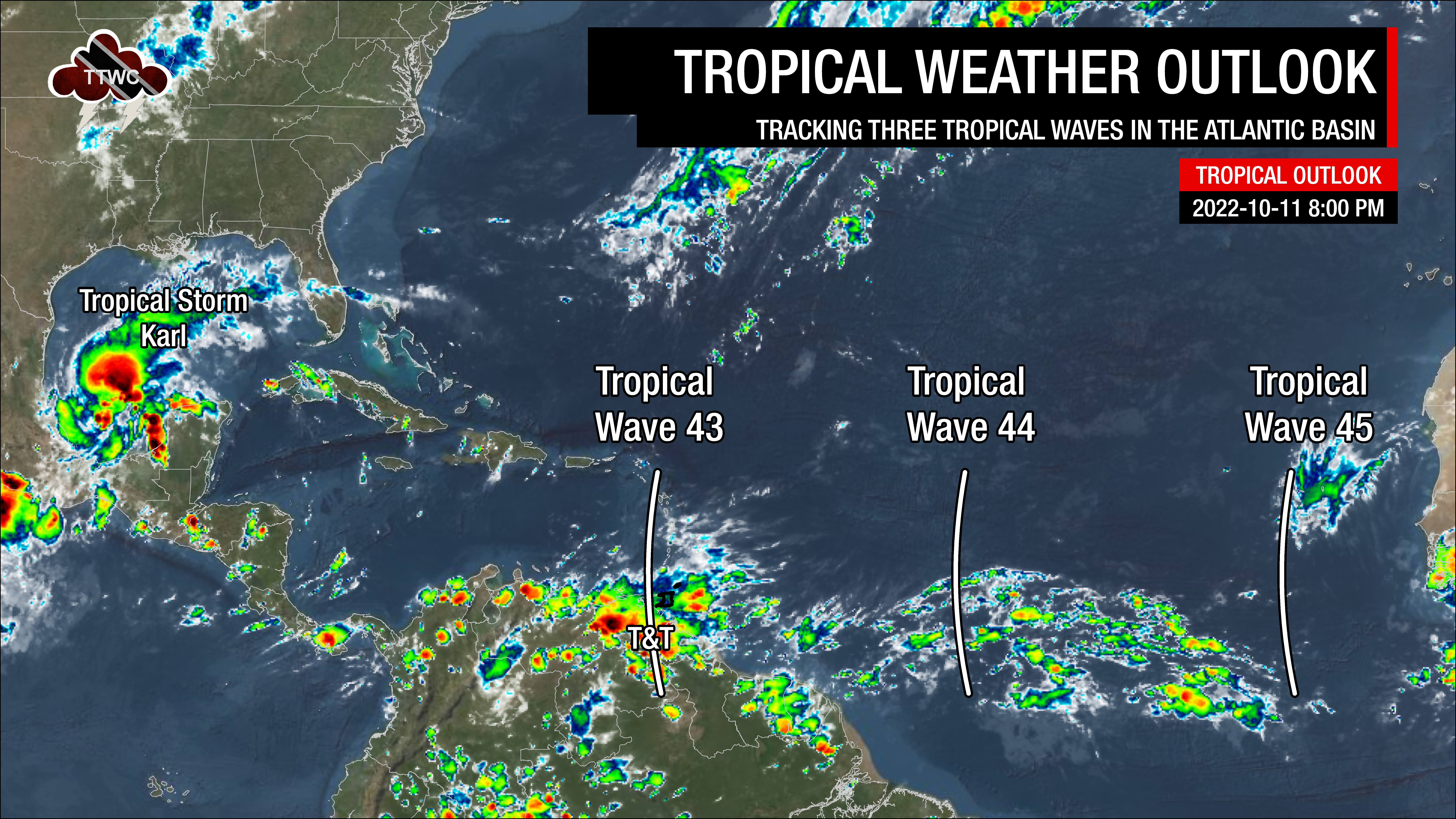
Tropical Waves (and other notable weather features) near and east of T&T: Based on the Tropical Analysis and Forecast Branch’s 18Z surface analysis on October 11th, 2022, as well as the latest satellite and model guidance:
- The 43rd tropical wave for 2022 (TW43) is along 61°W, south of 19°N, moving west at 10 knots (18 KM/H). This wave is moving across T&T and the Lesser Antilles on Tuesday night, moving out of the region by late Wednesday, October 12th, 2022. Scattered showers and isolated thunderstorms are ongoing from Trinidad and Tobago to Guadeloupe.
- The 44th tropical wave for 2022 (TW44) is along 45°W, south of 17°N, moving west at 10 knots (18 KM/H). This wave is forecast to move across T&T and the Lesser Antilles by Friday, October 14th, 2022. Scattered showers and isolated thunderstorms have been noted generally near where the wave interacts with the Intertropical Convergence Zone.
- The 45th tropical wave for 2022 (TW45) is along 27°W, south of 16°N, moving west at 10 knots (18 KM/H). Scattered showers have been observed with this wave across the Cabo Verde Islands. Model guidance shows this wave lingering in the Central Tropical Atlantic through next week as it interacts with a deep-layered trough system.
On Tuesday and into Wednesday, Tropical Wave 43’s deep-layered moisture and favorable upper-level conditions are forecast to support widespread cloudiness, periods of rain, isolated to scattered showers, and isolated thunderstorms. Favorable mid to upper-level conditions are forecast to continue supporting similar activity through Wednesday afternoon.
Then, a reduction in mid to low-level moisture is forecast from late Wednesday while a weak surface to low-level ridge builds across the region. This high-pressure system will lead to mostly sunny skies, weak winds, and low-level cloud patches, bringing brief isolated showers. With light winds, daytime heating, sea breeze convergence, and orographic effects are forecast to trigger/enhance showers or the odd thunderstorm across western and hilly areas of both islands on Thursday through the weekend.
An increase in low to mid-level moisture on Friday through the weekend, with favorable upper-level conditions, could support heavier rainfall along western and northern areas of Trinidad. However, wind shear is forecast to remain strong to very strong, limiting persisting rainfall, heavy showers, or thunderstorms.
Through the forecast period, Saharan Dust is forecast to remain present, gradually decreasing in concentrations across Trinidad.


