Long period swells originating from powerful low-pressure systems in the North Atlantic (ex-Hurricane Danielle and Earl) are now moving across the Lesser Antilles. These high-energy waves have already begun to affect T&T, increasing the risk of rip currents and battering waves along select coastlines.
What you need to know
— What is happening: Beginning Tuesday morning, swells with periods up to 15 seconds have begun to affect Trinidad and Tobago’s northern coastlines. Over the next 48 hours, swells are forecast to continue, affecting sheltered coastlines of Trinidad in the Gulf of Paria, with swell periods gradually decreasing.
— What can we expect: Large, battering waves are possible along T&T’s northern coastlines, with choppy conditions in sheltered areas. Minor to moderate coastal erosion is possible. There is a high risk of rip currents along the country’s northern coastlines. Spring Tides end on Tuesday, with the overall sea state in open waters moderate through the alert period.
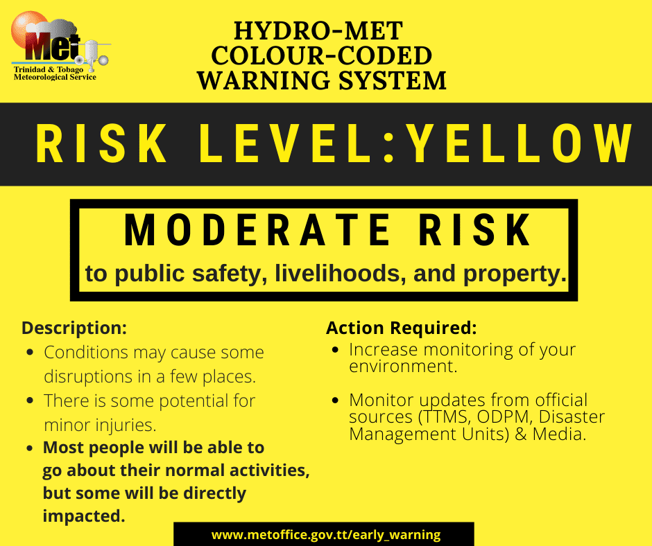
— Alerts/Watches/Warnings: A Hazardous Seas Alert (Yellow Level) remains in effect for northern Trinidad and Tobago, as well as sheltered coastlines of Trinidad in the Gulf of Paria from 12:00 PM Tuesday, September 13th, 2022, and remains in effect through 8:00 PM Thursday, September 15th, 2022, from the Trinidad and Tobago Meteorological Service. There are no tropical storm or hurricane watches or warnings in effect for T&T at this time.
The Hazardous Seas Alert
The Trinidad and Tobago Meteorological Service issued a Hazardous Seas Alert (Yellow Level) on Tuesday at 9:55 AM. The alert went into effect for northern Trinidad and Tobago from 12:00 PM Tuesday, September 13th, 2022, and remains in effect through 8:00 PM Thursday, September 15th, 2022. Swells are forecast to propagate into the Gulf of Paria through Tuesday, affecting the north-facing coastlines of southwestern Trinidad.
Trinidad and Tobago is not under any tropical storm watch or warning at this time.


“Long period swells of up to 15 seconds have been observed nearby and will eventually affect the vulnerable near-shore and coastal areas of Trinidad and Tobago,” according to the Trinidad and Tobago Meteorological Service. This “alert” status takes into account the possibility of the event occurring. This hazardous sea event has been observed.

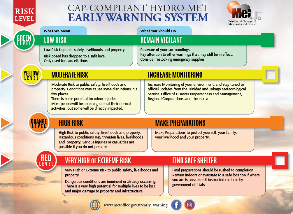
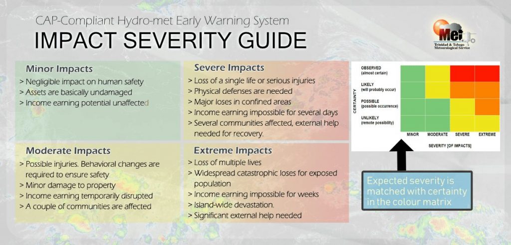
The color of the alert indicates the severity of the event and the probability of the event occurring. Currently, the alert level is Yellow. This means that the hazards have been observed, but the severity of impacts is moderate for this particular alert. Large battering waves and a high risk of rip currents are the two main hazards associated with this swell events.
For a moderate Hazardous Seas Alert, there is the potential for possible injuries, where behavioral changes are required to ensure safety. There may be minor damage to property, with income-earning temporarily disrupted and a couple of communities affected.
The Met Office is advising sea bathers, fishermen, and small craft operators to carefully monitor coastal sea conditions and exercise caution along the coast. They added, “avoid entering the sea if unnecessary, be alert for large breaking waves and choppy in near-shore zones and follow the instructions of lifeguards.”


Forecast and Impacts

Over the next seven days, seas are forecast to be slight to moderate into next week. Waves in open waters are forecast to be generally between 1.0 and 2.0 meters through the forecast period. In sheltered areas, waves are forecast to be less than 1.0 meter through Thursday, smooth from Friday through Saturday and near calm from Sunday, becoming occasionally choppy in heavy showers or thunderstorms, particularly within the Gulf of Paria.
Swell periods are forecast to remain between 11 and 15 seconds coming from the north over the next 48 hours, becoming between 6 to 11 from Friday onwards.
Winds are forecast to be gentle to light through next week with sustained winds between 0 to 15 knots from generally the south to the north with near calm winds possible on Thursday. Gusts during this period are forecast to reach 20 knots, accompanying isolated heavy showers or thunderstorms.
Spring tides are forecast to end on September 13th, 2022. These are higher than usual high tides and lower than usual low tides which may increase the risk of rip currents.


Saharan Dust is also forecast to remain at mild to moderate levels through the forecast period, marginally reducing visibility and air quality across Trinidad and Tobago.
Impacts possible from long period swells and possible battering waves include the following:
- Loss of life;
- Injuries;
- Coastal erosion;
- Localized disruptions of businesses;
- Sea search and rescue disruptions;
- Damage or loss of boats and fishing equipment;
- Disruptions to marine recreation and businesses
- Economic losses.
There is also the potential for loss of life. There is a high risk of rip currents, strong currents that can carry even the strongest swimmers out to sea.
How to spot a rip current
Rip Currents
High surfs can knock spectators off exposed rocks and jetties. Breaking waves may occasionally impact harbors making navigating the harbor channel dangerous.
Saltwater will likely splash onto low-lying coastal roads such as Pigeon Point Road, the Guayaguayare Mayaro Road at the Guayaguayare Sea Wall, and the Manzanilla-Mayaro Road. Bays and beaches may become inundated.
Coral reefs may experience increased stress and damages, in addition to localized beach erosion, particularly in areas where battering waves focus.


