


The Atlantic is entering a period where large tropical waves weaken the Atlantic High-Pressure System, causing weaker winds across T&T and the Lesser Antilles. When light winds occur under a moderate to high moisture environment, T&T experiences sunny days with heavy afternoon showers and thunderstorms favoring western and hilly areas – a pattern that is forecast to hold into the weekend.
What you need to know
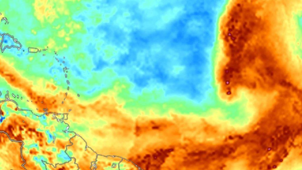
— Saharan Dust: Fluctuating Saharan Dust levels are forecast through Sunday, with a moderate to high-concentration surge arriving by Sunday night into Monday morning. Generally, higher dust concentrations are forecast to remain north of T&T.
— Rainfall: Isolated showers and thunderstorms are forecast through the next five days, interrupting mostly sunny skies. The wettest day is forecast to be Thursday. Over the next five days, 25 and 50 millimeters of rainfall is forecast across most of the country. Daily isolated rainfall totals up to 100 millimeters are possible across northern and western areas of Trinidad associated with heavy showers and thunderstorm activity.
— Hazards: The main hazards are localized street/flash flooding favoring the northern and western halves of Trinidad, with gusty winds up to and in excess of 45 KM/H accompanying heavy showers or thunderstorms. The chances for riverine flooding remain low at this time. Lightning will accompany thunderstorms. By Sunday evening, gusty winds are possible across the country, accompanying scattered thunderstorm activity.
— Alerts/Watches/Warnings: There are no alerts, watches, or warnings in effect for T&T from the Trinidad and Tobago Meteorological Service at this time.
The Forecast
Tuesday Night
Tuesday NightWednesday
WednesdayThursday
ThursdayFriday
FridaySaturday
SaturdaySunday
SundayMarine: Through Sunday, seas are forecast to be slight to moderate, with waves in open waters up between 1.0 and 2.0 meters. In sheltered areas, waves are forecast to be below 1.0 meter and occasionally choppy in the vicinity of heavy showers/thunderstorms.
Temperatures
Through the forecast period, the minimum low in Trinidad and Tobago is forecast to be between 23.0°C and 26.0°C.
Through the next five days, maximum highs across the country are forecast to be up to 33.0°C in Trinidad and 32.0°C in Tobago, with cooler maximum highs up to 31.0°C on Thursday across both islands due to increased cloud cover. In urbanized areas like Port of Spain, Scarborough, San Fernando, and Chaguanas, the maximum high temperatures could exceed 34.0°C.
Forecast Impacts
Flooding
FloodingThere is a high chance of street and flash flooding, particularly across the western and northern halves of Trinidad. Chances for riverine flooding remain low as major rivers across the country are well within their banks.
Forecast Rainfall Totals
- Wednesday: Less than 15 millimeters of rainfall across the country, trending higher across eastern Trinidad and Tobago.
- Thursday: Less than 25 millimeters across the country, with rainfall totals trending higher across eastern and southern areas of Trinidad.
- Friday: Less than 15 millimeters of rainfall across the country, trending higher across southern and eastern Trinidad.
- Saturday: Less than 15 millimeters of rainfall across the country, trending higher across southern and eastern Trinidad.
- Sunday: Less than 15 millimeters of rainfall across the country, trending higher across eastern Trinidad and Tobago.
Daily, highly isolated rainfall totals of up to 50 millimeters are likely in heavy showers and thunderstorms, particularly along western and hilly areas of Trinidad, with totals up to 100 millimeters possible.
Putting the rainfall forecast into context, rainfall rates in excess of 50 millimeters per hour or areas that receive in excess of 25 millimeters within an hour tend to trigger street flooding across the country or flash flooding in northern Trinidad. For riverine flooding to occur, a large area of the country (not just in highly localized areas of western coastal Trinidad) would have to record upwards of 75 millimeters within 24 hours, and rainfall would have to fall across major rivers’ catchment areas.
Strong Thunderstorms
Strong ThunderstormsThough the chances of strong thunderstorms remain fairly low, funnel cloud development is possible through the next five days due to near calm to light and variable winds. The highest chances for funnel cloud/waterspout development exist along western coastal areas of both Trinidad and Tobago, as well as along southern and eastern coastal areas of Trinidad. If a funnel cloud touches down on a body of water, it becomes a waterspout; if it touches down on land, it becomes a tornado.
While abundant frequent cloud-to-ground lightning isn’t likely, lightning is expected in thunderstorm activity.
Gusty Winds
Gusty WindsWith wind gusts up to and in excess of 45 KM/H, whole trees are expected to be in motion, and there may be some inconvenience when walking against the wind gusts. Light outdoor objects may topple or become airborne such as garbage cans, potted plants, loose galvanize or construction material, and other outdoor furniture. Tents may jump. Older/weaker trees may fall, bringing down utility poles and lines.
Other Hazards
Saharan Dust will fluctuate over the next five days, occasionally reducing air quality and affecting visibility.
Why I May Not/Will Not See Rainfall?
A frequent complaint is the forecast is wrong because I didn’t experience any rainfall. Scattered showers mean that you, individually, may experience some showers intermittently throughout the day, and there is a higher chance for this activity than isolated activity. Widespread showers mean that nearly all persons and areas may experience rainfall.
Isolated rainfall is forecast on over the next five days, with scattered rainfall possible on Thursday and Sunday.

Forecast Discussion
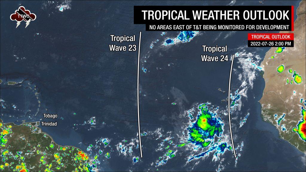
Tropical Waves East of T&T: Based on the Tropical Analysis and Forecast Branch’s 18Z surface analysis on July 26th, 2022, as well as the latest satellite and model guidance:
- The 23rd tropical wave for 2022 (TW23) is a large, elongated wave along 41°W, south of 27°N, moving west at 15 knots (28 KM/H). Scattered showers are noted where this wave interacts with the ITCZ/Monsoon Trough and further north near a surface trough. TW23’s highest moisture levels remain near the northern portion of the wave axis and are forecast to mostly affect the Leewards from Friday, July 29th, 2022.
- The 24th tropical wave for 2022 (TW23) is a large and broad tropical wave, along 20 to 25°W, south of 22°N, moving west at 15-20 knots (28-37 KM/H). Scattered moderate convection is ongoing near the Cabo Verde Islands. Dry stable air from the mid-latitudes is moving southward, north of the wave axis, suppressing thunderstorm activity further west of the wave. This tropical wave is forecast to move across the region on Sunday.
Trinidad and Tobago has entered the typical wet season pattern – a mostly hot and sunny start to the day, with heavy isolated showers and thunderstorms favoring western and hilly areas of Trinidad while sunny skies prevail elsewhere, leading to a mostly settled evening. However, a few features are enhancing and suppressing rainfall across the region.
A surface to low-level shearline has been affecting Trinidad and Tobago, as well as the remainder of the Southern Windward Islands, since Monday, with most showers and occasional cloudy periods remaining north of Trinidad but affecting Tobago. Moisture associated with this shearline has fuelled afternoon shower/thunderstorm activity along the western half of Trinidad, triggered by local climatic features (sea breeze convergence and daytime heating).
A weak trough to T&T’s east is forecast to move across the country on Thursday, with increased moisture moving across the area from as early as Wednesday afternoon into Thursday. Generally, winds are forecast to be light, allowing local climatic effects to act as triggers for showers/thunderstorms to develop, mainly during the afternoon. However, a reasonably dry mid- to upper-level environment, the presence of Saharan Dust, and moderate vertical wind shear will limit persisting showers and thunderstorms.
By late Thursday through Friday, dry air is forecast to return to T&T as TW23 moves across the Lesser Antilles. This dry air is forecast to limit showers and thunderstorms across the country. Most of the moisture and instability associated with this wave is forecast to affect the Northern Windwards and Leewards predominantly.
The southeasterly winds trailing the wave are forecast to pull higher atmospheric moisture from equatorial regions across T&T from early Saturday through the weekend, with TW24 approaching Saturday night into Sunday. While the overall atmosphere will become moist, wind shear will remain unfavorable for persisting showers or thunderstorms.
Forecast models indicate increased low-level winds across the Windwards on Sunday into Monday, which may translate into strong wind gusts with shower/thunderstorm activity. However, as this remains at the further end of the forecast period, forecast confidence remains low.


