


Flooding continues across several areas of Central and Eastern Trinidad on Sunday night as multiple rivers, streams, and drains are outside their banks and walls.
What you need to know
- The Caparo River has burst its banks and flooded several streets within the Caparo area. The Couva/Tabaquite/Talparo Regional Corporation has restricted vehicles from entering the area as of 6:00 PM Sunday, July 10th, 2022.
- Smaller rivers across Cunupia, Chase Village, and Perseverance are at capacity or overtopping their banks, flooding low-lying areas on Sunday night.
- Over the last 36 hours, there have been over 80 reports of flooding, landslides, fallen trees/utility poles, roof damage, and a collapsed home.
- Rainfall has subsided across T&T as a significant surge of Saharan Dust moves in, drying out the atmosphere. King Tides are ongoing, slowing runoff.
- During this inclement weather event, and as of present, there were/are no alerts, watches, or warnings in effect for T&T from the Trinidad and Tobago Meteorological Service. There are also no tropical storm or hurricane watches or warnings in effect for T&T.
8:35 PM – Flooding ongoing on Chin Chin Road exiting on to Ramgoolie Street South.
— TTWeatherCenter (@TTWeatherCenter) July 11, 2022
🎥: Nick’s Autohttps://t.co/hBAcmuthWu pic.twitter.com/d9ykHWOolI
Today’s Flooding
Heavy rainfall associated with the Intertropical Convergence Zone and Tropical Wave 17 began to affect Trinidad from late Saturday, July 9th, 2022. Activity intensified through Sunday morning with persisting heavy to violent rainfall rates and strong wind gusts.
10:00 AM – Conditions are beginning to gradually settle across T&T with mostly cloudy/overcast skies and light to moderate rain favoring Trinidad.
— TTWeatherCenter (@TTWeatherCenter) July 10, 2022
There is still the chance for an isolated heavy shower/thunderstorm through the early afternoon.
Forecast: https://t.co/c27WoIWxNd pic.twitter.com/vGxJa7ZVFi
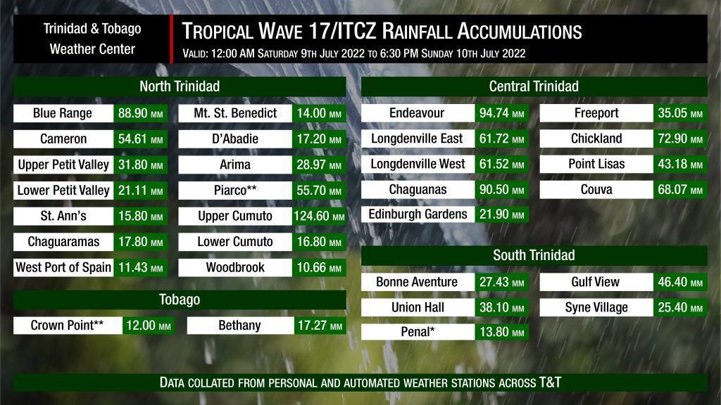
Across much of eastern, central, and southern Trinidad, rainfall accumulations exceeded one inch (25 millimeters), with rainfall totals across east and central Trinidad between 25 millimeters and 100 millimeters (4 inches). This was mostly in line with forecast rainfall totals. The highest measured rainfall total came in at Upper Cumuto with 124.60 millimeters (approximately 5 inches). Tobago was mostly spared the heavy rains, with 10 to 20 millimeters of rainfall recorded.
Flash flooding continues across multiple areas of Caparo, Central Trinidad following heavy rainfall. Areas near streams and minor rivers are still reporting rising flood waters as of 4:30 PM. Avoid venturing into flooding! https://t.co/c27WoIWxNd pic.twitter.com/NNcaIPMlE6
— TTWeatherCenter (@TTWeatherCenter) July 10, 2022
Putting the rainfall forecast into context, rainfall rates over 50 millimeters per hour or areas that receive more than 25 millimeters within an hour tend to trigger street flooding across the country or flash flooding in northern Trinidad. For riverine flooding to occur, a large area of the country (not just in highly localized areas of western coastal Trinidad) would have to record upwards of 75 millimeters within 24 hours, and rainfall would have to fall across major rivers’ catchment areas.
The major rivers (Caroni, North Oropouche, South Oropouche, Ortoire) are all within their banks as of Sunday night. However, the Caparo River has overtopped its banks, with streams and smaller rivers within Cunupia, Chase Village, and Perseverance near or at threshold levels.
Flash flooding renders the Caparo Valley Road, in the vicinity of Durham Mills Road impassable to most vehicles as of 2:30 PM
— TTWeatherCenter (@TTWeatherCenter) July 10, 2022
🎥: Nisha Ramkissoon-Balkaran
Forecast: https://t.co/c27WoIWxNd pic.twitter.com/EaQREh91Ci
As of 11:00 PM Sunday, July 10th, 2022, we’ve collated at least 67 reports of flooding across the country based on information reported directly to Trinidad and Tobago Weather Center as well as reports from the Ministry of Rural Development and Local Government and the Office of Disaster Preparedness and Management:
- Northwest Trinidad
- 1 Cizan Trace, Blue Basin
- Kelly Street, Diego Martin
- Tucker Valley Road, Diego Martin
- North-central Trinidad
- Between Maracas Bay and Marcas Lookout, North Coast Road
- Maracas Bay, North Coast Road
- Northeast Trinidad
- Cunapo Southern Main Road, Cumuto
- Cumuto Main Road, Cunaripo
- James Smart Village, Sangre Chiquto
- Bakers Trace, Sangre Grande
- Coalmine, Sangre Grande
- Cooryal Village, Sangre Grande
- Gilkes Street, Sangre Grande
- Guaico Tamana Road near the Cunaripo Masjid, Cunaripo
- Lovers Lane, Coalmine, Sangre Grande
- Little Cora Road, Cumuto
- St. Marie Emmanuel Road, Coryal
- Guatapajaro Road, Caratal Main Road, Cumuto
- Bon Air Road, Cumuto Tamana
- LP 339 Coryal Main Road, Coryal
- Veronica Boulevard, Coalmine, Sangre Grande
- Jarasingh Village, Guaico Tamana
- Harkoo Trace, Caratal
- Dynesty Drive, Sangre Chiquto
- Central Trinidad
- Caparo Valley Brasso Road in the vicinity of Carr Road, Caparo
- Caparo Valley Brasso Road in the vicinity of Durham Mills Road, Caparo
- Caparo Valley Brasso Road in the vicinity of Santa Phillipa Road, Caparo
- New Gunness Trace, Caparo
- Sharpe Road, Caparo
- Chandenagore Road, Carapichaima
- Orange Field Road, Carapichaima
- Persevereance Road, Carapichaima
- Ragoonanan Road West, Chandernagore Village, Carapichaima
- Ragoonanan Road East, Chandernagore Village, Carapichaima
- Savannah Heights, Charlieville, Chaguanas
- Lime Head Road, Chase Village
- David Tobago Road, Chin Chin
- Southern Main Road, Chin Chin
- Chin Chin
- Cedar Hill Road in the vicinity of A.M. Marketing Co. Ltd., Claxton Bay
- Mc Nair Circular, Cunupia
- Mon Plasir Road, Cunupia
- Mt Mariah Road, Cunupia
- Welcome Road North and South, Cunupia
- Ragoonanan Road, Enterprise
- Arena Road, Freeport
- Calcutta Road #1 and #2, Freeport
- Fairview Park, Freeport
- Northbound Solomon Hochoy Highway, Freeport
- Boy Cato Road, Las Lomas
- Dynasty Drive, Longdenville Road, Longdenville
- Palmiste Road, Longdenville
- Ravine Sable Road, Longdenville
- Mamoral #2, Mamoral
- Klensworth Road, Orange Field
- St Johns Road, Orange Field
- Le Blanc Road, Todds Road
- Pearl’s Bar, Todds Road
- Todds Station Road, Todds Road
- Joyce Trace, Carapichaima
- Esmerelda Road, Cunupia
- Cashew Gardens, Longdenville
- Ramgoolie East Trace, Chin Chin
- LP 52 Bonneaventure Trace, Cunupia
- South Trinidad
- St. Croix Road, Barrackpore
- Mulchan Road, Penal Rock Road
- Penal Rock Road in the Vicinity of Scott’s Road Junction, Penal Rock Road
- South Oropouche in the vicinity of S.M. Jaleel, Southern Main Road
Gusty Winds Bring Wind Damage Across Trinidad
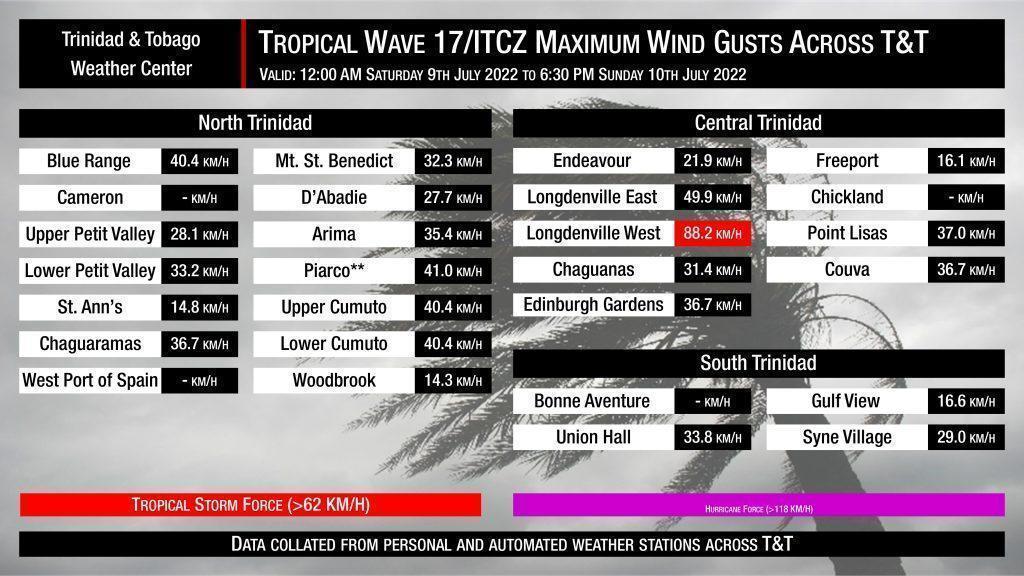
With low-level winds remaining moderate to strong over the last 48 hours, there was a high chance for wind gusts up to and over 45 KM/H with sustained winds up to 30 KM/H. Generally across Trinidad and Tobago, wind gusts remained within these forecast ranges. Stronger winds were likely across southeastern Trinidad, where weather stations are relatively devoid.
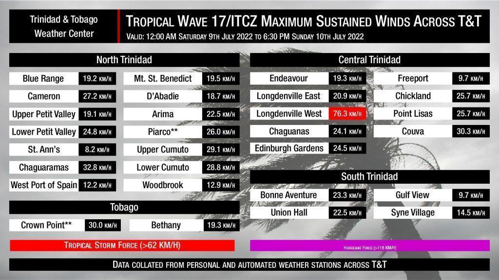
However, a highly localized and difficult to pinpoint system developed across Central Trinidad on Sunday morning, producing sustained winds and wind gusts up to tropical-storm-force strength.
Central Trinidad Microburst
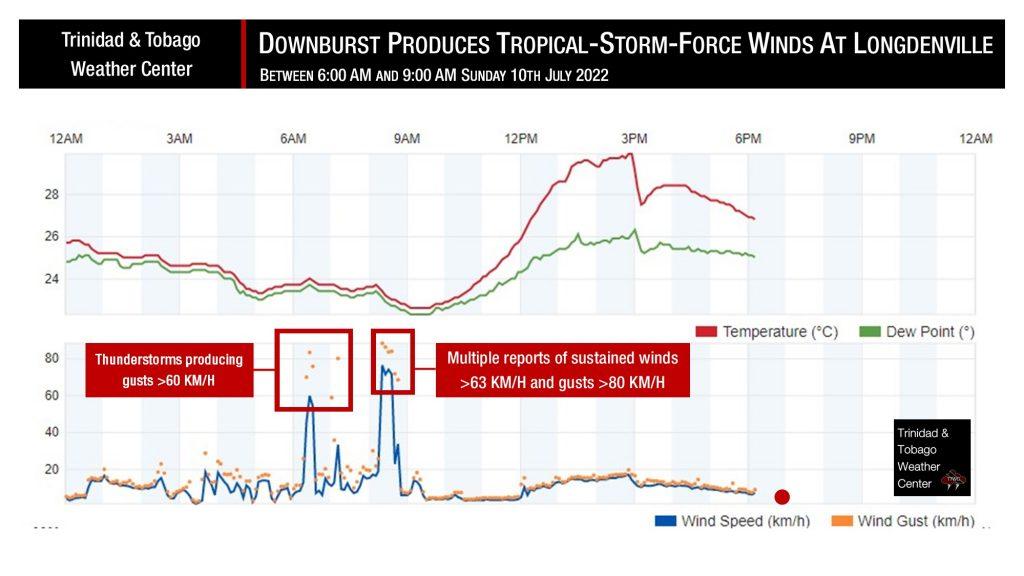
While many across Trinidad were concerned with the gusty winds accompanying heavy rainfall and thunderstorms on Sunday, residents of Londgenville experienced some of the strongest wind gusts and sustained winds the ITCZ and Tropical Wave 17 had to offer.
At a weather station in Longdenville, winds began to gust above 62 KM/H (tropical-storm-force) with 69.8 KM/H, 83.2 KM/H, and 75.6 KM/H gusts recorded at 6:21 AM, 6:26 AM, and 6:31 AM, while sustained winds during the period varied between 45.1 KM/H to 59.7 KM/H. However, an even more severe round of winds was coming.
From 8:21 AM, sustained winds and wind gusts entered the tropical-storm-force category at Longdenville. Winds peaked at 88.2 KM/H (gusts) and 76.3 (sustained) at 8:21 AM, but sustained winds above 70 KM/H persisted until 8:36 AM, while wind gusts above 62 KM/H continued until 8:41 AM.
This particular weather station in Longdenville automatically took measurements every five minutes. Another station, approximately 700 meters to the east-northeast, which takes measures every 15 minutes, recorded its strongest gust at 49.3 KM/H at 8:15 AM.

The highly localized nature of these winds is characteristic of a microburst (or a small downburst). A microburst is a pattern of intense winds that descends from rain clouds, hits the ground, and fans out horizontally. Microbursts are short-lived, usually lasting from about 5 to 15 minutes, and they are relatively compact, generally affecting an area of 1 to 3 km (about 0.5 to 2 miles) in diameter. They are often but not always associated with thunderstorms or strong rains. In this case, moderate to heavy rainfall rates were recorded during the strongest winds.
Remarkably, there were no wind-damage-related reports in the Longdenville area. However, as of 11:00 PM Sunday, July 10th, 2022, we’ve collated at least 11 reports of wind damage across the country based on information reported directly to Trinidad and Tobago Weather Center as well as reports from the Ministry of Rural Development and Local Government and the Office of Disaster Preparedness and Management:
- Blown-Off Roof
- La Savanne Circular, Guayaguayare
- Bristol Village, Mayaro
- Solomon Street, Mayaro
- 2 reports at St. Ann’s, Mayaro
- 6th Company Cir., Princes Town
- Fallen Trees
- Guaracara-Tabaquite Road, Tabaquite
- Maracas Royal Road, Maracas/St. Joseph
- Eastern Main Road, Manzanilla
- Toco Main Road in the vicinity of Quash Trace, Toco
- Fallen Utility Poles/Lines
- Maracas Royal Road, Maracas/St. Joseph
The fallen tree along the Toco Main Road in the vicinity of Quash Trace, Toco, temporarily rendered the roadway impassable. However, quick action by the Trinidad and Tobago Fire Service and a private company with a backhoe allowed the road to be cleared within an hour.
9:33 AM – The Toco Main Road in the vicinity of Quash Trace is now clear and passable due to action from TTFS and a private company.
— TTWeatherCenter (@TTWeatherCenter) July 10, 2022
📸: Anil Juteram
Forecast: https://t.co/c27WoIWxNd https://t.co/7SqzIi7ltP pic.twitter.com/yFJxfCb6XY
Other Reports
As of 11:00 PM Sunday, July 10th, 2022, based on reports from the Ministry of Rural Development and Local Government and the Office of Disaster Preparedness and Management’s 6:00 PM Situation Update, there were two reports of landslides at Mota Trace, Gran Couva and Realize Junction Road, Princes Town. The Mota Trace landslide resulted in one home collapsing.
There were no reports of injuries or fatalities due to Sunday’s inclement weather.
Forecast
A dense surge of Saharan Dust is now moving across Trinidad, Tobago, and the remainder of the Lesser Antilles. This dust surge is forecast to dry out low to mid-levels of the atmosphere, suppressing rainfall. Additionally, a high-pressure ridge is moving in across Trinidad and Tobago, which generally brings stable weather and is pushing the Intertropical Convergence Zone southward. However, variably cloudy skies are still forecast through Monday as upper-level conditions remain somewhat favorable and there is a moderate amount of atmospheric moisture present.
Our forecast for Monday:
Monday – Saharan Dust Dominates
Monday – Saharan Dust DominatesFor those wary of the next round of rainfall, Tropical Wave 18 and the Intertropical Convergence Zone are forecast to affect Trinidad and Tobago from Friday, July 15th, 2022, into the upcoming weekend.


