


As forecast, the Intertropical Convergence Zone and back-to-back tropical waves affected Trinidad and Tobago over the last 72 hours. Periodic rain, showers, and thunderstorms are forecast to continue through early Monday, with a dense plume of Saharan Dust moving across the Eastern Caribbean later today (Sunday).
What you need to know
— Saharan Dust: A significant surge of dust is forecast to arrive by late Sunday (today) and linger through the week, with brief improvement forecast by late Tuesday into late Wednesday and again by the weekend.
— Rainfall: Periodic light to moderate rain, isolated heavy to violent showers, and isolated thunderstorms are forecast across mainly Trinidad on Sunday, with isolated activity through the remainder of the week.
— Hazards: The main hazards over the next 24 hours, when most of the impactful weather is forecast, are gusty winds up to and in excess of 45 KM/H accompanying heavy showers or thunderstorms, as well as localized street/flash flooding favoring eastern and southern Trinidad. The chances for riverine flooding remain low at this time. Lightning will accompany thunderstorms.
— Alerts/Watches/Warnings: There are no alerts, watches, or warnings in effect for T&T from the Trinidad and Tobago Meteorological Service at this time. There are also no tropical storm or hurricane watches or warnings in effect for T&T.
The Forecast
Sunday – Tropical Wave 17 & The ITCZ
Sunday – Tropical Wave 17 & The ITCZMonday – Saharan Dust Dominates
Monday – Saharan Dust DominatesTuesday
TuesdayWednesday
WednesdayThursday – More Saharan Dust
Thursday – More Saharan DustMarine: Through Thursday, seas are forecast to be moderate with waves in open waters up to 2.0 meters, occasionally exceeding 2.0 meters on Sunday and Monday. In sheltered areas, waves are forecast to be near or below 1.0 meter, becoming choppy associated with increased low-level winds and rainfall activity on Sunday into Monday.
Temperatures
Through the forecast period, the minimum low in Trinidad and Tobago is forecast to be between 24.0°C and 27.0°C.
On Sunday, maximum highs across the country are forecast to be below 30.0°C in Trinidad and Tobago. In urbanized areas like Port of Spain, Scarborough, San Fernando, and Chaguanas, the maximum high temperatures could exceed 30.0°C.
From Monday, maximum highs across the country are forecast to be generally up to 32.0°C in Trinidad and Tobago. In urbanized areas like Port of Spain, Scarborough, San Fernando, and Chaguanas, the maximum high temperatures could exceed 33.0°C.
Forecast Impacts
Flooding
FloodingThere is a high chance of street and flash flooding, mainly on Sunday, and across central. southern, and eastern Trinidad. Chances for riverine flooding remain low as major rivers across the country are well within their banks.
Forecast Rainfall Totals
- Sunday: Across northwestern and north-central Trinidad, as well as most of Tobago, less than 15 millimeters of rainfall is forecast with isolated higher totals where heavy showers or isolated thunderstorms occur. Across the southern and eastern halves of Trinidad, between 25 and 50 millimeters of rainfall, with isolated higher totals up to 125 millimeters.
- Monday: Less than 5 millimeters across the country, with isolated totals up to 10 millimeters across eastern and southern areas of Trinidad.
- Tuesday: Less than 5 millimeters across the country, with isolated totals up to 10 millimeters mainly across eastern and southern areas of Trinidad.
- Wednesday: Between 5 and 15 millimeters across the country with rainfall totals trending higher across southern and eastern areas of Trinidad.
- Thursday: Less than 5 millimeters across the country, mainly across eastern areas of Trinidad and across Tobago.
Putting the rainfall forecast into context, rainfall rates in excess of 50 millimeters per hour or areas that receive in excess of 25 millimeters within an hour tend to trigger street flooding across the country or flash flooding in northern Trinidad. For riverine flooding to occur, a large area of the country (not just in highly localized areas of western coastal Trinidad) would have to record upwards of 75 millimeters within 24 hours, and rainfall would have to fall across major rivers’ catchment areas.
Strong Thunderstorms
Strong ThunderstormsFunnel cloud development is unlikely due to moderate to strong low-level winds. If a funnel cloud touches down on a body of water, it becomes a waterspout; if it touches down on land, it becomes a tornado.
While frequent cloud-to-ground lightning isn’t likely, lightning is expected in thunderstorm activity.
Gusty Winds
Gusty WindsWith wind gusts up to and in excess of 45 KM/H, whole trees are expected to be in motion, and there may be some inconvenience when walking against the wind gusts. Light outdoor objects may topple or become airborne such as garbage cans, potted plants, loose galvanize or construction material, and other outdoor furniture. Tents may jump. Older/weaker trees may fall, bringing down utility poles and lines.
Other Hazards
Saharan Dust will remain across the region through the forecast period, reducing air quality and affecting visibility.
Why I May Not/Will Not See Rainfall?
A frequent complaint is the forecast is wrong because I didn’t experience any rainfall. Scattered showers mean that you, individually, may experience some showers intermittently throughout the day, and there is a higher chance for this activity than isolated activity. Widespread showers mean that nearly all persons and areas may experience rainfall.
Isolated to scattered rainfall is forecast on Sunday, with isolated rainfall from Monday.

Forecast Discussion
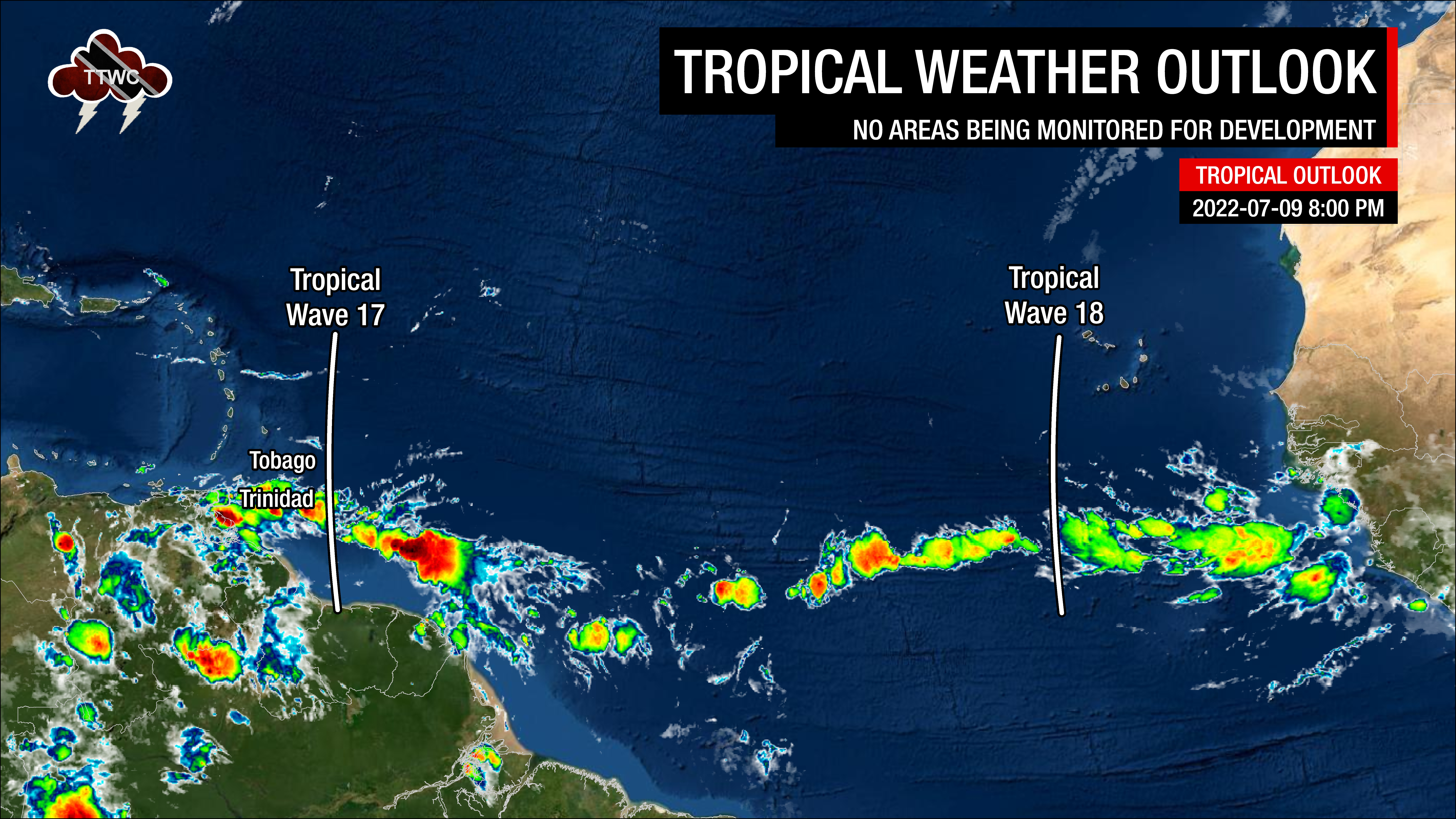
Tropical Waves East of T&T: Based on the Tropical Analysis and Forecast Branch’s 00Z surface analysis on July 10th, 2022, as well as the latest satellite and model guidance:
- The 17th tropical wave for 2022 (TW17) is along 56°W, south of 18°N, moving west at 20 knots (37 KM/H). Isolated moderate to strong convection as been noted where the wave interacts with the Intertropical Convergence Zone, mainly between 7°N to 10°N and 50°N to 60°N. This wave is forecast to move across T&T early Sunday.
- The 18th tropical wave for 2022 (TW18) is along 26°W, south of 18°N, moving west at 10-15 knots (18-27 KM/H). This wave is forecast to move across Trinidad and Tobago on Friday into Saturday, July 15th to 16th, 2022. There are some weak showers where the wave meets the ITCZ, while dense Saharan Dust limits convection elsewhere.
As of early Sunday morning, marginally favorable upper-level conditions are in place across Trinidad and Tobago, resulting from a stationary upper-level low anchored in the central Caribbean Sea. This upper-level low is creating favorable upper-level divergence across the Lesser Antilles and this pattern is forecast to hold through Tuesday, enhancing any shower or thunderstorm that develops.
At the lower levels, high atmospheric moisture and instability associated with the Intertropical Convergence Zone and Tropical Wave 17 is moving across Trinidad and Tobago, supporting broad cloudiness with rain, showers, and thunderstorms predominantly affecting southern and eastern areas of Trinidad. The ITCZ remains just south of the country but may drift across T&T on Sunday. Strong to very strong wind shear from the west to southwest continues to keep shower and thunderstorm activity brief.
A significant surge of Saharan Dust is forecast to trail Tropical Wave 17, beginning to move across the Eastern Caribbean by Sunday afternoon. This dust surge will be accompanied by a surface to a mid-level ridge that is forecast to establish across the Lesser Antilles through the week. While low-level cloud patches may bring brief showers through the week, enhanced by the upper-level low-pressure system through Tuesday, Saharan Dust is forecast to keep low to mid-levels of the atmosphere fairly dry. This setup is forecast to lead to partly cloudy and hazy skies, with the occasional brief shower, as reflected in the forecast through the week.
By late Thursday into Friday, the approach of Tropical Wave 18 is forecast to bring the Intertropical Convergence Zone back to Trinidad and Tobago, with high atmospheric moisture and instability set to affect the country through the weekend.


