


Two tropical waves and the Intertropical Convergence Zone are forecast to bring brisk showers and thunderstorms to Trinidad and Tobago over the next three days but Saharan Dust is forecast to put an end to that by the start of the upcoming week.
What you need to know
— Saharan Dust: Decreasing concentrations of Saharan Dust are forecast on Friday into Saturday, with a significant surge of dust forecast to arrive by late Sunday and linger through the forecast period.
— Rainfall: The wettest days during the forecast period are expected to be Friday through early Sunday, though overall rainfall totals aren’t expected to be particularly high. Rainfall will be due to two tropical waves and the ITCZ.
— Hazards: The main hazards over the next 72 hours, when most of the impactful weather is forecast, are gusty winds up to and in excess of 45 KM/H accompanying heavy showers or thunderstorms, as well as localized street/flash flooding. The chances for riverine flooding remain low at this time. Lightning will accompany thunderstorms.
— Alerts/Watches/Warnings: There are no alerts, watches, or warnings in effect for T&T from the Trinidad and Tobago Meteorological Service at this time. There are also no tropical storm or hurricane watches or warnings in effect for T&T.
The Forecast
Friday – Tropical Wave 16 & The ITCZ
Friday – Tropical Wave 16 & The ITCZSaturday – Tropical Wave 17 Approaches
Saturday – Tropical Wave 17 ApproachesSunday – Tropical Wave 17 Passes
Sunday – Tropical Wave 17 PassesMonday – Saharan Dust Dominates
Monday – Saharan Dust DominatesTuesday
TuesdayMarine: Through next Tuesday, seas are forecast to be moderate with waves in open waters up to 2.0 meters, occasionally exceeding 2.0 meters from late Thursday. In sheltered areas, waves are forecast to be near or below 1.0 meter, becoming choppy by late Thursday into Friday, associated with increased low-level winds and rainfall activity.
Temperatures
Through the forecast period, the minimum low in Trinidad and Tobago is forecast to be between 24.0°C and 27.0°C.
Through Sunday, maximum highs across the country are forecast to be below 30.0°C in Trinidad and Tobago. In urbanized areas like Port of Spain, Scarborough, San Fernando, and Chaguanas, the maximum high temperatures could exceed 30.0°C.
From Monday, maximum highs across the country are forecast to be generally up to 32.0°C in Trinidad and Tobago. In urbanized areas like Port of Spain, Scarborough, San Fernando, and Chaguanas, the maximum high temperatures could exceed 33.0°C.
Forecast Impacts
Flooding
FloodingThere is a medium chance of street and flash flooding, mainly from Friday into Sunday. Chances for riverine flooding remain very low as major rivers across the country are well within their banks.
Forecast Rainfall Totals
- Friday: Across west-central, northwestern and north-central Trinidad, as well as most of Tobago, less than 10 millimeters of rainfall is forecast with isolated higher totals where heavy showers or isolated thunderstorms occur. Across the southern and eastern halves of Trinidad, between 10 and 20 millimeters of rainfall, with isolated higher totals.
- Saturday: Across west-central and northwestern Trinidad, less than 10 millimeters of rainfall is forecast with isolated higher totals where heavy showers or isolated thunderstorms occur. Across the southern and eastern halves of Trinidad, as well as across Tobago, between 10 and 20 millimeters of rainfall, with isolated higher totals up to 35 millimeters.
- Sunday: Between 5 and 20 millimeters of rainfall across the country with higher rainfall totals nearing 25 millimeters across eastern and southern Trinidad, as well as eastern Tobago.
- Monday: Less than 5 millimeters across the country, with isolated totals up to 10 millimeters across eastern and southern areas of Trinidad.
- Tuesday: Less than 5 millimeters across the country, mainly across eastern areas of Trinidad.
Putting the rainfall forecast into context, rainfall rates in excess of 50 millimeters per hour or areas that receive in excess of 25 millimeters within an hour tend to trigger street flooding across the country or flash flooding in northern Trinidad. For riverine flooding to occur, a large area of the country (not just in highly localized areas of western coastal Trinidad) would have to record upwards of 75 millimeters within 24 hours, and rainfall would have to fall across major rivers’ catchment areas.
Strong Thunderstorms
Strong ThunderstormsFunnel cloud development is unlikely due to moderate to strong low-level winds. If a funnel cloud touches down on a body of water, it becomes a waterspout; if it touches down on land, it becomes a tornado.
While frequent cloud-to-ground lightning isn’t likely, lightning is expected in thunderstorm activity.
Gusty Winds
Gusty WindsWith wind gusts up to and in excess of 45 KM/H, whole trees are expected to be in motion, and there may be some inconvenience when walking against the wind gusts. Light outdoor objects may topple or become airborne such as garbage cans, potted plants, loose galvanize or construction material, and other outdoor furniture. Tents may jump. Older/weaker trees may fall, bringing down utility poles and lines.
Other Hazards
Saharan Dust will remain across the region through the forecast period, reducing air quality and affecting visibility.
Why I May Not/Will Not See Rainfall?
A frequent complaint is the forecast is wrong because I didn’t experience any rainfall. Scattered showers mean that you, individually, may experience some showers intermittently throughout the day, and there is a higher chance for this activity than isolated activity. Widespread showers mean that nearly all persons and areas may experience rainfall.
Isolated to scattered rainfall is forecast through Sunday, with isolated rainfall from Monday.

Forecast Discussion
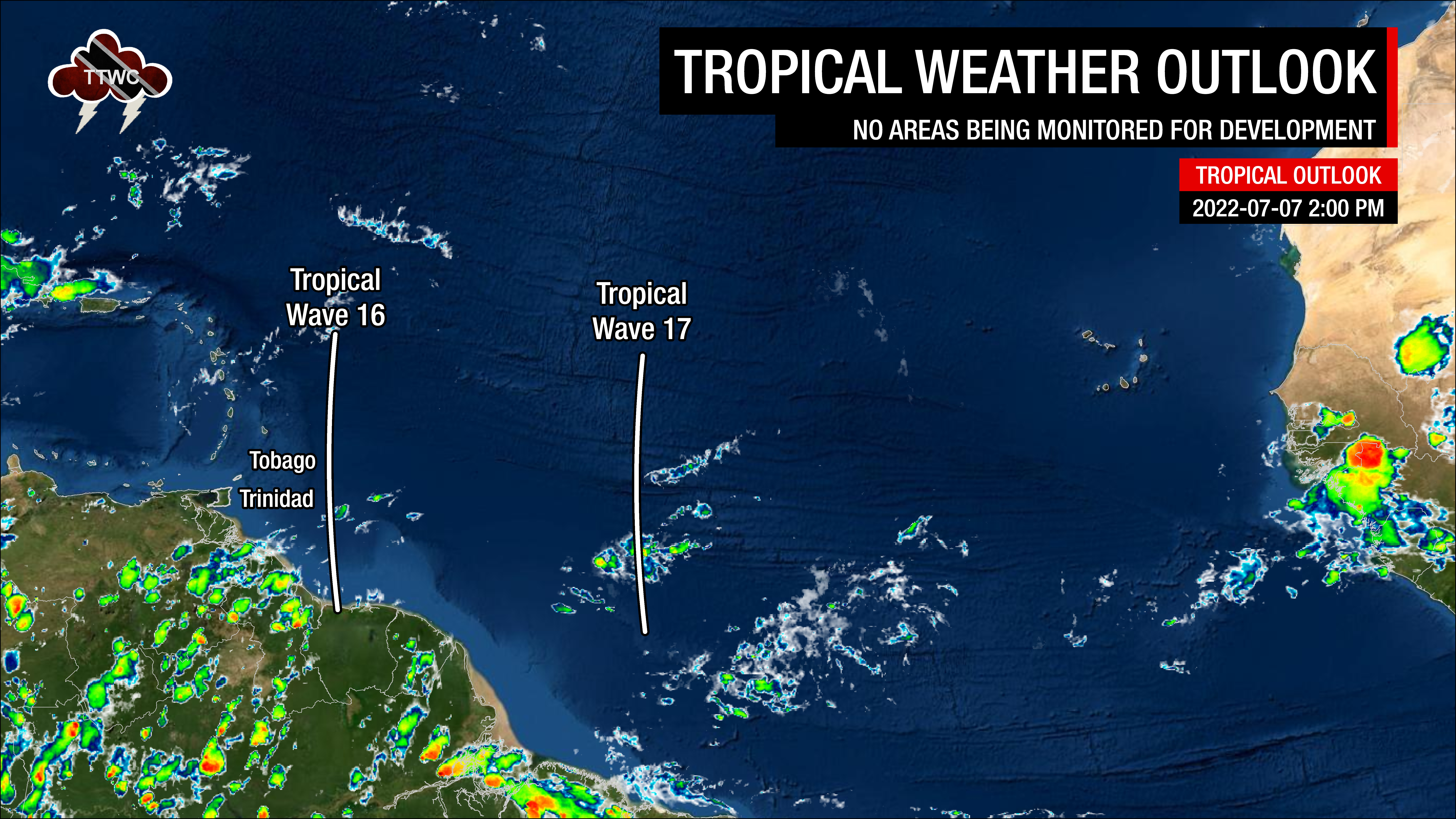
Tropical Waves East of T&T: Based on the Tropical Analysis and Forecast Branch’s 18Z surface analysis on July 7th, 2022, as well as the latest satellite and model guidance:
- The 16th tropical wave for 2022 (TW16) is along 56/57°W, south of 21°N, moving west at 15 knots (27 KM/H). Dry Saharan Dust is suppressing convection, but this wave is set to move across T&T on Friday, bringing the ITCZ across the country.
- The 17th tropical wave for 2022 (TW17) is along 40/42°W, south of 20°N, moving west at 15 knots (27 KM/H). This wave is forecast to move across Trinidad and Tobago on Saturday, July 9th, 2022, into Sunday, June 10th, 2022. There are some weak showers where the wave meets the ITCZ, while dense Saharan Dust limits convection elsewhere.
Through Thursday, a broad surface to mid-level central Atlantic high-pressure system was the dominant feature, with the low to the mid-level atmosphere relatively dry and stable.
However, showers and isolated thunderstorms are set to begin affecting Trinidad and Tobago associated with Tropical Wave 16 on Friday, July 8th, 2022, which is dragging the ITCZ closer and across the country. The ITCZ will remain present across or near Trinidad and Tobago through Monday as Tropical Wave 17 is forecast to traverse the region on Saturday, July 9th,, 2022 into Sunday, July 10th, 2022.
Through early Monday, high atmospheric moisture is forecast to be present across the country. However, moderate to strong wind shear will keep these weak tropical waves and the ITCZ devoid of deep and widespread convective activity.
Additionally, following the passage of Tropical Wave 17 early Sunday, a surge of Saharan Dust accompanying the reestablishment of surface to mid-level ridge pattern will bring mostly settled weather across the country.
However, on Monday, competing weather features will be present, leading to mixed weather conditions. The combination of a surface to low-level ridge pattern and a mid to upper trough, meridionally oriented just to the west of the island chain battling for dominance will allow for a mix of hazy and cloudy skies and clouds with a few sporadic scattered showers. As the ITCZ drifts southward, isolated rainfall activity may continue to affect southern Trinidad through Sunday and early Monday.
By Tuesday, the ridge holds dominant, leading to hazy, breezy, and mostly settled conditions across the country.


