As the hurricane season nears, we begin to look farther east for the beginnings of tropical activity, as far east as Africa for tropical wave features.
Tropical waves, also called African easterly waves, are among Trinidad and Tobago’s main rainfall-producing features. Approximately 60 waves track across the Atlantic Ocean annually, and 30-40 directly impact Trinidad and Tobago.
At its peak, predominantly between June and September, Trinidad and Tobago is affected by approximately one tropical wave per week.
What is a Tropical Wave?
A tropical wave is a type of trough, i.e., an elongated area of relatively lower air pressure that is typically oriented north to south. It moves east to west across the tropical easterlies. Tropical waves are also called African Easterly Waves or Tropical Easterly Waves.
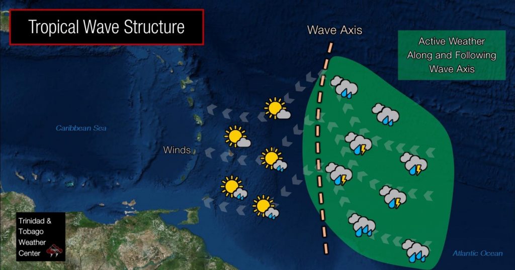
Tropical Waves can be significant rainfall producers in the tropics, with heavy convection (thunderstorms) usually on the east side of the wave axis and generally clear weather on the west side of the axis. Convection is highly modulated by atmospheric moisture, upper-level atmospheric dynamics, and topography. These waves can develop into tropical cyclones if conditions are optimal – generally light upper-level winds, warm sea surface temperatures, and favorable latitude (generally above 10 degrees north).
Generally, these waves are inverted troughs of low pressure, seen as an inverted V-pattern in satellite imagery. These tropical waves can have a few points of origin. However, the National Hurricane Center designates these troughs of low pressure when there is a clear origin from convection in Northern Africa and the African Easterly Jet. Other local and regional organizations can sometimes apply these definitions to surface-to-low-level troughs generated in the East Atlantic near Western Africa or the Gulf of Guinea.
This may come across to the layman as pedantic, as the impacts of locally heavy rainfall, thunderstorms, and gusty winds are possible regardless of designation. However, the designation is significant to Trinidad and Tobago because the passage of the first Tropical Wave (or the first time the ITCZ modulates across T&T) signals the start of the rainy season for the islands. Following the passage of the first true tropical wave, as designated by either the National Hurricane Center or by the discretion of the Trinidad and Tobago Meteorological Service, the rainy season is declared.
The official meteorological definition of a tropical wave, as defined by the World Meteorological Organization, is a trough or cyclonic curvature maximum in the trade wind easterlies or equatorial westerlies. The wave may reach maximum amplitude in the lower middle troposphere or reflect an upper-troposphere cold low or equatorial extension of a mid-latitude trough.
How Are Tropical Waves Generated?

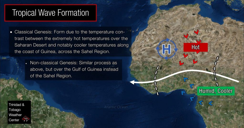
Tropical Waves are generated by an instability (baroclinic-barotropic instability) of the African Easterly Jet (AEJ). The AEJ arises as a result of a reverse lower tropospheric temperature gradient over West-Central-North Africa. This is due to extremely hot temperatures over the Saharan Desert and notably cooler temperatures along the coast of Guinea.
Organized convection along the Near Equatorial Trough over North Africa during the Northern Hemisphere Summer results in perturbations. Meso-scale Convective Complexes (MCC) and Meso-scale Convective Systems (MCS) over this region are also responsible (if not the primary source) for the generation of TWs, providing cyclonic rotation to these waves in the process.
The classical genesis of a tropical wave occurs between Ethiopia and the Sahel Region and is analyzed by the United States National Hurricane Center in their surface analysis. However, other African origins, such as those waves originating in the Gulf of Guinea, are sometimes considered tropical origins for tropical wave designation. These waves can also be generated due to ITCZ interactions and heating.
In addition, particularly later in the Hurricane Season, tropical waves can also form from mid-level troughs, which develop into low-level troughs (tropical waves). These are typically designated in the United States National Hurricane Center’s Tropical Analysis and Forecast Branch’s surface analysis.
The frequency of TWs peaks in July, when that contrast is the highest in western Africa. At this time of year, about 10 tropical waves roll off the African continent per month.
In the early part of the hurricane season, easterly waves are often dry because they collect dry air from the Sahara Desert.
Dry air often pools in the eastern Atlantic and stretches to the eastern Caribbean islands, often referred to as the “Saharan Air Layer.” It can sometimes reach the Southeastern U.S., providing drier conditions and more colorful sunsets.
From July through September, TW’s are more likely to contain thunderstorms and thus are more likely to become tropical storms and hurricanes.
Tropical Wave Characteristics

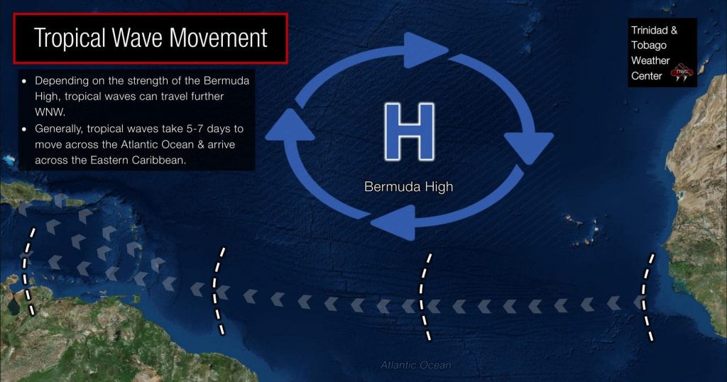
Movement: TW’s generally travel east to west at 10 to 15 knots (18.5 KM/H to 28 KM/H). The movement of these features is dependent on larger atmospheric features in the North Atlantic, such as the strength of the Azores High, a subtropical, high-pressure system that dominates the North Atlantic during the Atlantic Hurricane Season. These waves can move west-northwestward or faster across the Atlantic Ocean, depending on the strength of this system.
Frequency & Timing: TW’s typically begin to develop and propagate across the Atlantic Ocean from May to June, continuing through October to November. The US National Hurricane Center and the US Hurricane Research Division track on average 60 TW’s leaving North Africa annually. These waves move off the Western African Coast every 3-4 days and typically take 5-7 days to move across the Atlantic Ocean before moving across Trinidad, Tobago, and the Eastern Caribbean. On average, 30-40 tropical waves affect Trinidad and Tobago annually from May through November, with the peak number of waves occurring between June and September.
Associated Weather

Calm Before the Storm – Ahead of TW’s, there is typically upper-level convergence and low-level divergence, resulting in a dry, subsiding pattern. Hence, it may be mostly sunny and hot ahead of a tropical wave.
Changing Wind Direction – As a TW moves through the Eastern Caribbean, the most notable diagnostic, which is that it is indeed a tropical wave moving through the area, is a wind shift. Over the Eastern Caribbean, the prevailing easterly winds will begin to take a more northeast component (i.e., winds from the northeast) as the TW approaches. When the TW is over the area, winds return briefly to mainly from the east but then take an east-southeasterly component as the axis progresses westward. This wind shift is why it may seem that rain may fall from the “wrong direction” compared to normal during the rainy season.
Active Weather – Following the TW, there is generally low-level convergence, upper-level divergence, and associated deep-layered moisture. These conditions create optimal conditions for moderate to strong convective showers and thunderstorm development. It is common for weather associated with TW’s cause street/flash flooding, gusty winds resulting in downed trees, utility poles, and even landslides, frequent lightning in thunderstorms, and even riverine flooding in prolonged wet periods. TW’s can also drag the ITCZ northward, enhancing showers and thunderstorms across the Eastern Caribbean, namely the Southern Windwards, including Trinidad and Tobago.
Saharan Dust – Following strong tropical waves, with large thunderstorms moving off the West African Coast, significant volumes of Saharan Dust can be kicked up into the atmosphere and follow the wave as it progresses across the Atlantic. This dust can hinder convection from forming from the TW, reflect sunlight, and briefly cool the air and ocean surface below the dust plume.
Tropical Cyclones – Not all TW’s develop into tropical depressions, tropical storms, or hurricanes. However, when conditions are right, i.e., warm ocean temperatures, light upper-level winds, and the axis of the wave has sufficient latitude, to name a few conditions, tropical cyclones can form. Tropical waves are the origin for approximately 60% of Atlantic Tropical Cyclones and 85% of major Atlantic Hurricanes (Category 3 and above).
Note that the above structure describes a positively tilted TW. Negatively tilted tropical waves exist and occur a few times per year. We see active weather ahead of the TW instead of behind the wave axis with a negatively tilted TW.
Tracking Tropical Waves

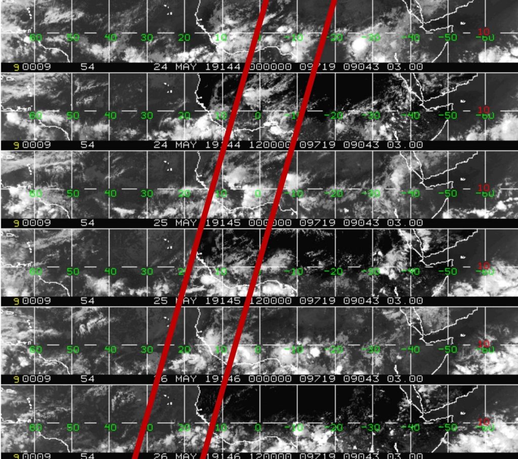
A number of tools are used to track the genesis and progression of tropical waves. However, the main tool is satellite imagery, which uses specialized diagrams called Hovmöller Diagrams (above).
It is easy to pinpoint a tropical wave on visible satellite imagery by looking for the inverted “V” signature. These waves also show up well at the 700—and 850-millibar levels. Tropical waves tend to have a significant volume of atmospheric moisture. Hence, by tracking the above features, in addition to surface observations from meteorological stations and ships, meteorologists can track these tropical waves from on-land Africa across the Atlantic, Caribbean, and into the Americas.
Not Every Tropical Wave Brings Severe Weather
Tropical waves vary in intensity as they travel westward across the Atlantic. This variability can be in the order of days or as short as hours. Sometimes, you may see satellite imagery that shows heavy thunderstorms and deep convective activity east of Trinidad and Tobago during the late night and early morning, but by daybreak, nothing.
This is due to diurnal (daily) variations in convective showers whereby convection peaks overnight and wanes during the day for already occurring convective systems (i.e., not triggered by daytime heating).
Tropical wave activity can be enhanced by its proximity to upper-level troughs and the ITCZ, but can also be degraded by hostile upper-level conditions and Saharan Dust.


