


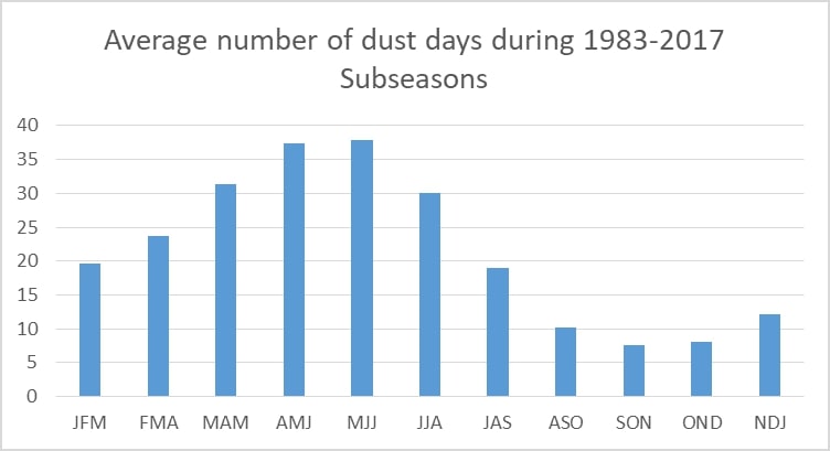
Over the next several months, Trinidad and Tobago will be entering the peak of the annual Saharan Dust season. According to the Trinidad and Tobago Meteorological Service (TTMS), the number of days in which Saharan Dust (and dust haze) is present peaks in June.
In their latest three-month Rainfall and Temperature Outlook, issued on April 1st, 2022, the TTMS noted that during April through June 2022, the number of Saharan Dust haze days is “expected to increase significantly in frequency.”
Since November, Trinidad, Tobago, and the remainder of the Lesser Antilles have experienced mild to high concentration surges of Saharan Dust. These dust plumes generally reduce air quality to moderate levels and, at times, levels that are unhealthy for sensitive groups.
The surges of dust are due to the Harmattan, a season in the West African subcontinent that occurs between the end of November and the middle of March. During this season, a predominant northeasterly trade wind (dubbed the Harmattan Winds) blows from the Sahara Desert over Western Africa into the Gulf of Guinea.
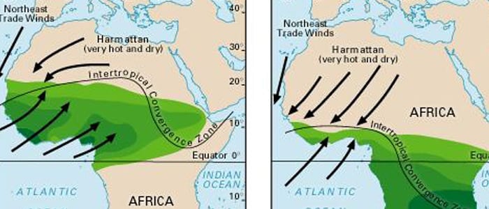
A ridge of high pressure stays over the central Sahara Desert, and the Intertropical Convergence Zone (ITCZ) remains over the Gulf of Guinea during these five months. The Harmattan wind accelerates when it blows across the mountain massifs of Northwest Africa. If its speed is high enough and it blows over dust source regions, it lifts the dust and disperses it. Dust that makes it into the upper levels of the atmosphere can then get transported across the Atlantic Ocean and affect the Eastern Caribbean.
November through mid-March Saharan Dust outbreaks tend to be milder in the Eastern Caribbean than the dust outbreaks associated with West African thunderstorms driving dust into the upper atmosphere from April through November. West African thunderstorms are generally related to incipient Tropical Waves, which is why the region experiences a surge of Saharan Dust after the passage of a Tropical Wave from late May through November.
According to the Met Office, the duration of Saharan Dust plumes over the next three months are likely to be longer than what T&T has experienced earlier this year, with increased odds of higher dust concentrations.
Saharan Dust Days Increasing Across Trinidad and Tobago
Many complain that Saharan Dust is a new phenomenon. Unfortunately, this dusty misery has existed as long as the Sahara Desert, and it is a vital source of nutrients for the Amazon Rainforest.
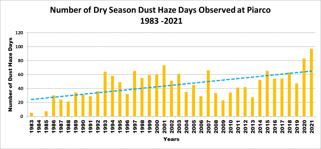
However, recent data from the Trinidad and Tobago Meteorological Service suggests that the dust events have markedly become more frequent. In the 1980s, Saharan Dust was present between 25-35 days during the five to six-month span of the Dry Season. By 2020, this average increased to over 60 days during the same five to six-month Dry Season span.
One study, published in November 2019 in the journal JGR: Atmospheres, suggests more dust has been transported out of the Sahara in the last 100 years than in centuries past. The study also suggests that periods of drought in North Africa, especially in the Sahel region south of the Sahara, are linked to stronger dust events. If these droughts happen more frequently in the future, scientists might expect Saharan dust events to intensify. But it’s not clear whether that will be the case.
Whether we’ll see more or less Saharan Dust in the coming years is far from certain. Using a combination of satellite data and computer models, NASA brings better news. They predict that Africa’s annual dust plumes will actually shrink to a 20,000-year minimum over the next century due to climate change and ocean warming. Recent NASA research outlines the domino-like connections between factors beyond the desert’s borders and the development of dust plumes. These start with temperature differences between the North and South Atlantic, which then impact the region’s consistent east to west winds and a tropical band of relatively high rainfall located near the Equator, both of which impact the annual dust plumes.
Research has also linked Saharan dust plumes to other natural climate variables, such as El Niño events. Some of these climate variables may also change as the world continues to warm in ways scientists are still investigating.
So, for now, the future of Saharan dust plumes remains unclear. What remains unchanged is the impact of our dusty future on the air quality across Trinidad and Tobago, so you should pay closer attention to Saharan Dust forecasts and learn what you can do to protect yourself.


