


Seismic zones are areas or regions of seismicity where there is a common cause of seismic events.
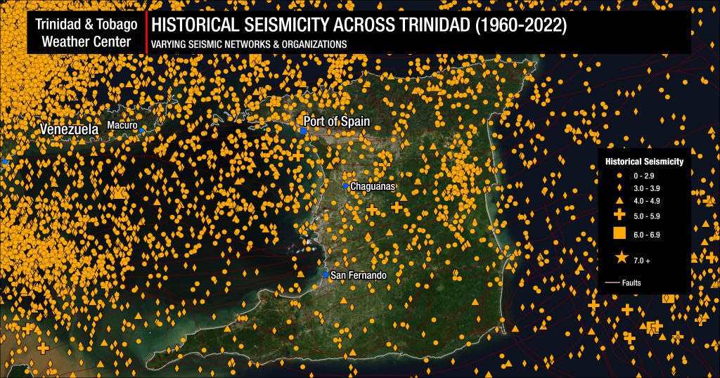
Trinidad and Tobago and the surrounding region are very seismically active areas. Across the Eastern Caribbean, over 2,200 earthquakes are recorded annually. Since 1990, the U.W.I. SRC records an annual average of 280 earthquakes in the Trinidad and Tobago region (area bounded by 9.5°- 11.5°N & 59.5°W – 63.5°W). Of these 280 quakes, 50 of these seismic events are, on average, above magnitude 3.5. This means, on average, we expect to see approximately 23-24 earthquakes per month, with 4-5 earthquakes larger than M3.5.

Within the Trinidad and Tobago region, we can see periods of elevated seismicity in the form of earthquake swarms. These swarms can occur in any seismic zone, but we’ve seen swarms occur in the Gulf of Paria and near Carúpano, Venezuela, over the last few years.
Because of the complex geophysics and tectonics associated with Trinidad, earthquakes within these zones are mainly attributed to two processes: subduction and strike-slip faults related to the transverse boundary of the South American and Caribbean plates.
To the east of Trinidad and Tobago, the South American plate begins to be subducted under the Caribbean plate. This subduction continues under Trinidad and Tobago with a gentle gradient. Across Tobago, according to estimates from the United States Geological Service’s Slab 2.0 Model, the South American plate begins at 42-46 kilometers below the island. Across Trinidad, the South American plate is 46-56 kilometers below the island.
However, at the easternmost tip of Venezuela’s Paria Peninsula, the depth of the South American plate starts at 60 kilometers and rapidly dives into the Earth’s crust as you move westward, with the slab of the plate starting at 140 kilometers at Carúpano, Venezuela.
Closer to the surface, generally above 40-kilometer depth, the South American plate and the Caribbean plate are sliding past one another. The Caribbean plate moves in an easterly direction at about 20 millimeters per year.
Rather than moving continuously, the plates tend to become locked along planar fault segments, accumulate strain then rupture in zones.
These zones have been regionally defined, locally defined, and redefined by the UWI Seismic Research Centre.
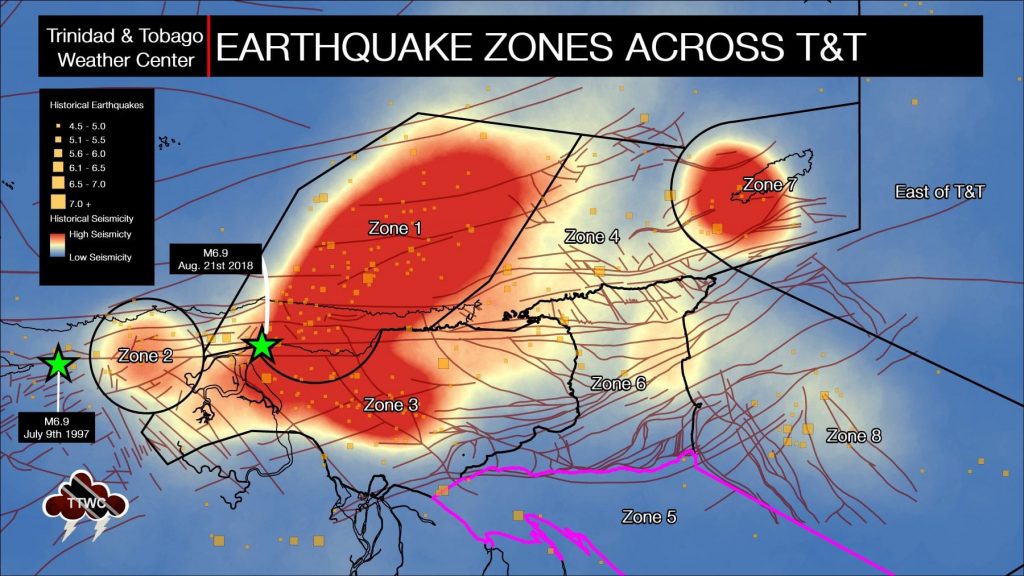
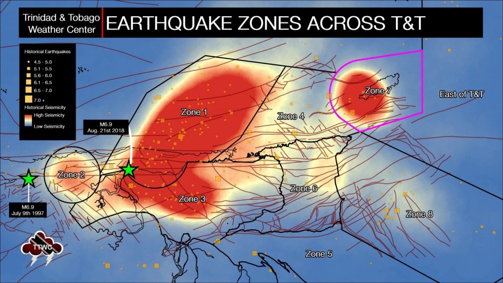
Zone 1: The Paria Peninsula

Seismic zone one is a complex and, without a doubt, the most seismically active area near Trinidad. According to the UWI SRC, this area is the second most seismically active area in the Eastern Caribbean and has generated major-great earthquakes in historic times.
The 1766 magnitude 7.9 event, estimated to have been located in this area, destroyed the then Capital of San José. The 1888 magnitude 7.5 event was damaging from Trinidad to St. Vincent. The largest event for the instrumental period, i.e., since 1952, occurred on September 20th, 1968, and was of magnitude 7.0. Significant damage was caused in Venezuela, and Trinidad, where there was damage in Port of Spain.
In this area, the South American plate is beginning to rapidly descend into the Earth’s mantle as the detached oceanic lithosphere exists at depths between 50 to 300 kilometers within zone one. (Russo et al. 1993).
At shallower levels, the North Coast Fault Zone and the El Pilar Fault, part of the Boconó-San Sebastian-El Pilar Fault system, run across Zone 1. These fault systems compensate for the stress built up as the Caribbean plate slides past the South American plate. Hence, most of these earthquakes from these fault systems are shallow to moderate depths between 0 to 70 kilometers.
The UWI SRC says approximately 65 events of magnitude 2.1 and above are located in the area annually.
Zone 2: The El Pilar Fault (Irapa- Carúpano Area)

This zone comprises part of the boundary between the Caribbean and the South American plate. The events in this area are generally shallow, with hypocenters less than 50 kilometers deep. They are usually characterized mainly by right-lateral strike-slip movement along the northern coast of South America.
The El Pilar Fault, in the vicinity of Carúpano, has several smaller, conjugate, or perpendicular faults which frequently produce earthquake swarms. This location is hypothesized to have a higher frequency of earthquakes than other locations along the El Pilar Fault Zone due to a kink in the fault system, with higher stress levels building in this zone than elsewhere.
Zone 3: Central Gulf of Paria & East Central Coastal Venezuela

The Gulf of Paria is yet another very faulted, seismically complex area surrounding Trinidad. At this zone, the extension of the Los Bajos fault from southwestern Trinidad and the Warm Springs Fault from Central Trinidad meets the El Pilar fault. This complex network of faults also includes small, conjugate or perpendicular faults.
High levels of seismic activity occur in this zone, with both shallow and moderate depth earthquakes generally remaining less than 50 kilometers in depth. The UWI SRC has stated during a Q&A of the earthquake swarm between January and February 2018 that this location can generate a magnitude 6.5 or greater earthquake.
According to the UWI SRC, approximately 40 events of magnitude 2.1 and above are located in this area annually. One event in the magnitude range of 4.6-5.0 is expected every year, and one in the magnitude range of 5.1-5.5 approximately every five years. The zone generates earthquakes ranging in depth from less than 15 kilometers to over 150 kilometers. These deeper events are usually associated with subduction within the Paria Peninsula (Zone 1).
The UWI SRC also noted that most events of depth less than 16 kilometers tend to be clustered near 10.35°N and 62.3°W in the Gulf of Paria. The events closer to Trinidad form a more diffuse cloud and tend to be located deeper than 15 kilometers.
Zone 4: North of Trinidad

Earthquakes in Zone 4 can be associated with the subducting slab of the South American Plate, resulting in a deeper hypocenter between 40-55 kilometers, but it can be deeper. Quakes in this area can also be associated with the North Coast Fault System, which runs just offshore the Northern Coast of Trinidad, where events are usually less than 40 kilometers in depth. This area typically produces light (M4.0-4.9) or moderate (M5.0-5.9) magnitude earthquakes. Earthquakes in this zone tend to produce fewer aftershocks than earthquakes elsewhere across Trinidad and Tobago.
In the UWI SRC.’s profile of the area, they estimate approximately 28 events of magnitude 2.1 and above are located annually, with an earthquake in the magnitude range 4.6-5.0 occurring every five years, the most recent being in 2005.
The UWI SRC says the largest known earthquake in this area was of magnitude 6.5 and occurred on December 4th, 1954. One person was killed, and many were injured. There was a significant amount of minor to moderate damage in northern Trinidad. The biggest event since 1954 was of magnitude 5.2 and occurred on New Year’s Day of 1996.
Zone 5: South of Trinidad
Russo et al. (1993) defined this zone as a passive margin edge in the Foreland Basin in the north of South America, covering events with strike-slip and mixed thrust and thrust around the Orinoco-Delta region in Venezuela with an average depth of 50 kilometers and a maximum magnitude of 6.5. This zone is fairly seismically quiet regarding earthquakes larger than magnitude 3.8. Generally, we see episodic moderate (M5.0-M5.9) earthquakes.
According to the S.R.C., during the instrumental period since 1952, there has been negligible seismicity generated in the zone closest to Trinidad. However, the Amacuro Delta in eastern Venezuela periodically generates earthquakes above magnitude 5.0.
Zone 6: On Land Trinidad
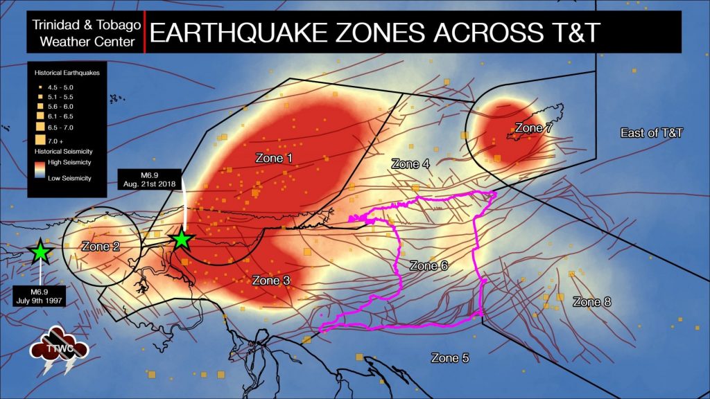
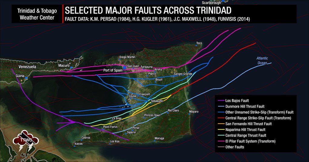
Trinidad is a highly faulted area, with several fault systems running across the island – all due to compensation of the lateral movement of the Caribbean and South American plates. Several major fault systems run across, on land, Trinidad, including the El Pilar Fault system, the Central Range Fault, Northern Range Fault, Darien Ridge, Los Bajos Fault, and the Arima Fault. Earthquakes on-land across Trinidad are typically less than 50 kilometers.
There was some variance in this typical depth due to an earthquake swarm in the Toco area in 2001. There have also been some moderate magnitude earthquakes occurring at a deeper depth.
According to the UWI SRC, since 1980 and before 2004, there have been, on average, 13 events annually, in general of magnitude less than 4.1. There was, however, one event in 1981 with a magnitude of 4.8. Since 2001, there has been an increase in the number of earthquakes recorded, with a sequence occurring in 2004/2005, which generated two events in the magnitude 5.1-5.5 range. Most of the events occur at depths below 20 kilometers.
On December 2nd, 2004, events with magnitudes of 5.5 and 5.1 occurred in the central north-east of Trinidad. The location of these earthquakes and the corresponding focal mechanisms coincides with the Northern Range faults dipping southward mapped by Algar & Pindell (1993) beneath the Caroni Swamp Area. Fault plane solutions suggest a normal motion with a right-lateral strike-slip component.
Zone 7: South & West of Tobago
Zone 7 is a fairly complex area where earthquake swarms associated with the Caribbean-South American plate boundary at depth (subducting) have occurred several times (Latchman 2009, Weber 2009, Burmester et al. 1996). At this location, there are intersections between the transform faults and subduction zones of the Lesser Antilles. Until 1982, this area was considered a seismically quiet area, with low seismic hazard based on the low level, low magnitude output.
On September 20th, 1982, a magnitude 5.2 earthquake occurred, beginning an earthquake sequence for many months thereafter. In April 1997, a strong earthquake measuring magnitude 6.1 occurred, the largest earthquake recorded in this zone during the instrumental era. This quake caused at least TT$18M worth of damage in Tobago alone.
Shallow to moderate earthquakes (0 to 60 kilometers depth) occurred in the past, with right-lateral strike-slip and normal faulting occurring (Morgan et al. 1988; Latchman 2009). Earthquakes of magnitudes 6.0-6.5 have occurred in this region.
Zone 8: East of Trinidad, South of Tobago.

This zone, similar to Zone 7, was considered a low seismic hazard based on the low level, low magnitude output until March 10th, 1988, when an earthquake measuring Mt 6.3, east of Trinidad, effectively activated that zone. Since then, earthquakes have been episodic, with moderate (M5.0-M5.9) magnitudes.
According to the UWI SRC, there have been episodic sequences in 1994 and 2004, interspersed by a low level of background earthquakes. Currently, the annual average is about 25 earthquakes. The majority of events in the area occur at depths below 35 kilometers.
Earthquakes within this zone are generally shallow to moderate in depth, generally remaining less than 70 kilometers. Research has suggested that earthquakes within this zone are consistent with the detachment and bending-flexure of the South American plate (slab) subducting and moving toward the collision zone (Russo & Speed, 1992).
Earthquakes at this location are typically due to normal faulting or strike-slip faults. These quakes occur at an average depth of 45 kilometers.
Why have seismic zones?
Ultimately, earthquakes can occur at any time and any location across Trinidad and Tobago. Seismic zones help emergency planners, seismologists, and other relevant personnel determine the earthquake potential of different places. In addition, it can help determine the most likely areas an earthquake may occur.


