Over the next five days, weather across the Southern Windwards, including T&T, will be anything but settled. Through Saturday, Tropical Wave 15 is forecast to interact with the Intertropical Convergence Zone in the area, leading to rainfall. Then, Invest 95L, a tropical disturbance with high chances of formation, is forecast to track across the region on Monday.
Though the eventual size and intensity of Invest 95L are still uncertain, the track places the low-pressure area north of T&T, sparing the country of the most intense rains and winds. However, an atypical wind regime and possible feeder band activity bring hazards of their own.
Then, another strong tropical wave being monitored for development is forecast to track across the Windwards on Wednesday.
What you need to know
— Rainfall: Over the next five days through the night of July 3rd, 2024, overall rainfall accumulations across the country are forecast to range from 40 to 110 millimeters, with totals up to 125 millimeters favoring northern and eastern areas of Trinidad, as well as Tobago and localized western parts of Trinidad. In isolated areas, five-day totals may reach as high as 175 millimeters.
— Saharan Dust: Mild Saharan Dust is forecast to be present through Saturday, with a moderate surge forecast on Sunday through early Monday.
— Hazards: Over the next five days, several hazards are forecast. In heavy showers/thunderstorms, there is the risk of gusty winds exceeding 45 KM/H, up to 60 KM/H, locally intense rainfall producing street/flash flooding, frequent lightning in intense thunderstorm activity, landslides in elevated areas, particularly northern Trinidad and Tobago, funnel cloud activity on Monday, and hazardous seas.
— Marine: Generally moderate seas are forecast over the next five days, with rough seas in open waters likely on Monday, and hazardous conditions possible on Monday through Tuesday in the Gulf of Paria.
Latest Alert
Adverse Weather Alert Extended For T&T Until 10 AM Tuesday
The Forecast
Friday
FridaySaturday
SaturdaySunday
SundayMonday
MondayTuesday
TuesdayWednesday
WednesdayMarine Forecast
Seas Forecast: Rough Seas Likely on Monday in T&T’s Waters
Temperatures
Friday
Low: 25-27°C
High: 31-33°C
Saturday
Low: 25-27°C
High: 29-31°C
Sunday
Low: 25-27°C
High: 31-34°C
Monday
Low: 24-26°C
High: 30-34°C
Tuesday
Low: 25-28°C
High: 30-32°C
Wednesday
Low: 24-26°C
High: 30-32°C
Forecast Impacts
Flooding
FloodingForecast Rainfall Totals
- Friday: Across the country, between 10 and 25 millimeters are forecast, with isolated totals exceeding 25 millimeters, favoring eastern areas. In isolated thunderstorm activity, rainfall totals exceeding 25 millimeters are possible, favoring Trinidad.
- Saturday: Across the country, between 10 and 25 millimeters are forecast, with isolated totals up to 50 millimeters. In isolated thunderstorm activity, rainfall totals exceeding 50 millimeters are possible, favoring the northern and eastern halves of Trinidad, as well as Tobago.
- Sunday: Across the country, trace accumulations and 5 millimeters are forecast, with isolated totals up to 15 millimeters, favoring eastern and western coastal areas. In isolated thunderstorm activity, rainfall totals exceeding 15 millimeters are possible.
- Monday: Across Trinidad, between 5 and 15 millimeters are forecast, with totals up to 35 millimeters, favoring Tobago, western and eastern coastal Trinidad, as well as the northern half of Trinidad. In feeder band activity and in heavy showers/thunderstorms, locally higher totals are likely.
- Tuesday: Across the country, between 5 and 15 millimeters are forecast, with totals up to 25 millimeters, favoring eastern Trinidad, as well as Tobago. In isolated thunderstorm activity, rainfall totals exceeding 25 millimeters are likely.
- Wednesday: Across the country, between 5 and 15 millimeters are forecast, with totals up to 25 millimeters, favoring eastern Trinidad, as well as Tobago. In isolated thunderstorm activity, rainfall totals exceeding 25 millimeters are likely.

Understanding Rainfall Accumulations
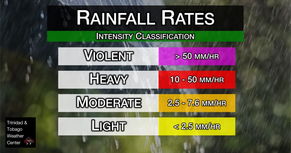
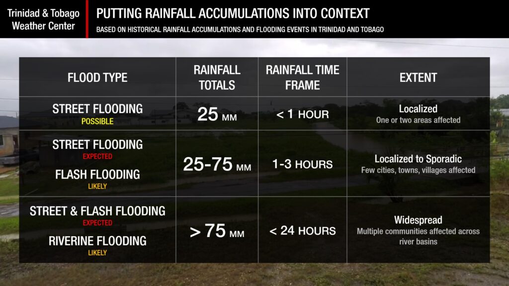
Putting the rainfall forecast into context, rainfall rates in excess of 50 millimeters per hour or areas that receive in excess of 25 millimeters within an hour tend to trigger street flooding across the country or flash flooding in northern Trinidad. For riverine flooding to occur, a large area of the country (not just in highly localized areas of western coastal Trinidad) would have to record upwards of 75 millimeters within 24 hours, and rainfall would have to fall across major rivers’ catchment areas.

Strong Thunderstorms
Strong ThunderstormsWhat is a strong or severe thunderstorm?
Given how rare these types of thunderstorms are in our region – we classify a severe or strong thunderstorm as one that produces any of the following:
- Damaging wind gusts exceeding 55 KM/H;
- Frequent lightning (more than 30 cloud-to-ground strikes within a 10-minute period);
- Hail (of any size);
- Rainfall of more than 50 millimeters or more within an hour or exceeding 75 millimeters or more within three hours;
- The sighting of a funnel cloud or touchdown of a waterspout/tornado associated with the thunderstorm.
Gusty Winds
Gusty WindsWith winds gusting to 60 KM/H and occasionally above, whole trees can be in motion, with larger trees and weaker branches falling. Light outdoor objects can topple or become airborne, such as garbage cans, loose galvanize, construction material, and outdoor furniture. Tents may also jump.
Other Hazards
Saharan Dust Forecast
Saharan Dust Surges Forecast To Follow Disturbances, Tropical Waves
Why I May Not/Will Not See Rainfall?
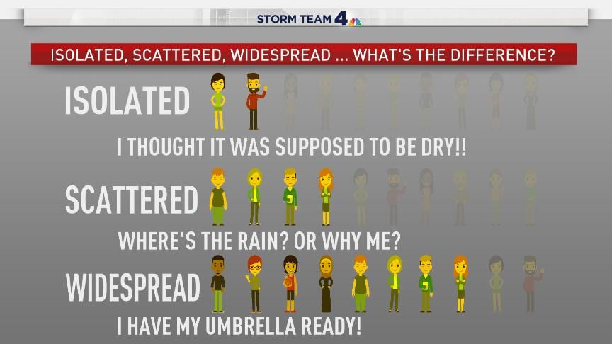
A frequent complaint is the forecast is wrong because I didn’t experience any rainfall. Scattered showers mean that you, individually, may experience some showers intermittently throughout the day, and there is a higher chance for this activity than isolated activity. Widespread showers mean that nearly all persons and areas may experience rainfall.
On Friday and Saturday, scattered rainfall is forecast, with isolated to scattered rainfall on Monday through Wednesday.

Forecast Discussion
Tropical Update
NHC: Hurricane Beryl Expected to Bring ‘Life-Threatening’ Winds, Storm Surge to Windwards
Trinidad and Tobago is entering a five-day period of very active weather.
On Friday and Saturday, the Intertropical Convergence Zone, interacting with Tropical Wave 15, is forecast to produce showers and thunderstorms across Trinidad and Tobago. Particularly on Saturday, with relative humidity through the atmosphere above 80%, light shear (below 10 knots), and a very favorable upper-level pattern with strong upper-level divergence, locally heavy showers and thunderstorms are likely.
A brief ridge pattern is forecast to move in on Sunday, between Tropical Wave 15 and the eventual system originating out of Invest 95L, with a brief surge of Saharan Dust moving in as well. On Sunday, winds are forecast to decrease, becoming increasingly light towards the night, with a weak northerly component. As the low-pressure system originating out of Invest 95L nears, outer bands of convergence are forecast to move in from the north/northeast into Monday.
Based on the current model guidance. which is fairly certain of the track of the core of the low-pressure system but less certain of the size and intensity of the system; showers and thunderstorms are likely to affect Tobago and, to a lesser extent, Trinidad, early Monday morning through daybreak, with activity continuing across Tobago throughout the day.
Trinidad, on the other hand, will experience a mostly humid, warm, and still day on Monday after the early morning showers/thunderstorms subside, with rainfall possibly favoring northern and eastern areas. Stronger southerly winds may also lead to isolated thunderstorms being enhanced by topography, and with clockwise-turning winds through the atmosphere, the potential for funnel clouds will also exist.
Due to the wind flow now coming from the south (initially southwest, becoming southeast by midnight), strong afternoon and evening thunderstorms along the north coast of Venezuela are forecast to drift north to T&T by the evening. Top models indicate that the cluster of thunderstorms is forecast to move across both islands into Tuesday morning, with the most intense activity remaining in the Gulf of Paria.
On Monday night through Tuesday, and in feeder band activity, the pressure gradient between the low-pressure system north of T&T and a high-pressure system over northern South America will lead to strong low-level southeasterly winds across the area. These winds can reach the surface in showers or thunderstorms. Wind gusts exceeding 45 KM/H are likely during this period, and gusts as high as 60 KM/H are possible.
By Tuesday evening, a brief surge of Saharan Dust is forecast to move in, but another disturbance in the far eastern Atlantic, is forecast to track near or even across T&T. However, it is too soon to tell what impacts, if any, this system may bring. Top global forecasting models do show isolated to scattered showers and thunderstorms, but similar to Invest 95L, the most intense rains and winds remain north of T&T. This is another system we’ll be paying close attention to in the coming days.
Note that as an extended forecast goes further into the future, it is normal for the certainty to be reduced relative to the extended period.


