


Mariners will have to exercise extreme caution over the next seven days due to a myriad of hazards, chief among them being the passage of a low-pressure area north of T&T that is set to agitate seas on Monday and influence our wind flow on Tuesday. As a result, the Trinidad and Tobago Meteorological Service is likely to issue a Hazardous Seas advisory, at least for Monday, due to forecast conditions.
Another strong tropical wave is set to affect the region by mid-next week and is forecast to agitate seas once more. Spring Tides are set to begin on Tuesday.
Additionally, choppy seas are forecast across Trinidad and Tobago due to showers and thunderstorms.
Latest Alert

Adverse Weather Alert Extended For T&T Until 10 AM Tuesday
Seas Forecast For Trinidad and Tobago

Saturday: Seas are forecast to be moderate in open waters, with waves between 1.5 and 2.0 meters. In sheltered areas, waves are forecast to be near 1.0 meter, with occasional choppy conditions in the vicinity and during heavy showers/thunderstorms. Swell periods are forecast to range between 6 and 9 seconds. Winds are forecast to range between 10 and 15 knots from the east-northeast to southeast and gusting to 25 knots. No marine advisories.
Sunday: Through the late afternoon, seas are forecast to be moderate in open waters, with waves between 1.5 and 2.0 meters. In sheltered areas, waves are forecast to be near 1.0 meter, with occasional choppy conditions in the vicinity and during heavy showers/thunderstorms. Swell periods are forecast to range between 6 and 9 seconds. Initially, winds are forecast to range between 5 and 15 knots from the northeast to the southeast. By the evening, these winds are forecast to move from the northeast to north, ranging between 15 and 20 knots, gusting to 25 knots. Choppy conditions are likely along northern sheltered areas, as well as north-facing coastlines of the Gulf of Paria.
Monday: For seas in open waters north and east of Trinidad, waves are forecast to range between 1.5 and 2.5 meters, with waves in Tobago’s open waters reaching as high as 3.5 meters. However, this forecast can be adjusted based on the strength of the approaching low-pressure area east of the Windward Islands, currently Invest 95L, as it moves across the region. In sheltered areas, seas are forecast to range between 1.0 and 1.5 meters, and choppy in heavy showers and thunderstorms. Note that winds are forecast to initially be from the north through the mid-morning, then from the west during the late morning, ranging between 0 and 10 knots. From midday through the remainder of Monday, winds are forecast to be from the south to southeast, between 10 to 20 knots, gusting to 30 knots. Swell periods between 7 and 13 seconds are forecast. Due to northward-moving showers and thunderstorms, choppy conditions are likely in the Gulf of Paria, particularly in the evening and along south-facing coastlines. Hazardous marine conditions are likely in T&T’s open waters.
Tuesday: Seas are forecast to be moderate in open waters, with waves between 1.5 and 2.0 meters. In sheltered areas, waves are forecast to be between 1.0 and 1.5 meters, and conditions may become locally rough and/or choppy in the vicinity of heavy showers or thunderstorms. Winds are forecast to be from the southeast to east between 15 to 25 knots, gusting to 30 knots. Swell periods between 6 and 9 seconds are forecast. Spring Tides ongoing. Choppy conditions are likely in the Gulf of Paria, particularly in the evening and along south-facing coastlines, due to northward/northwestward-moving showers and thunderstorms.
Wednesday: Seas are forecast to be moderate in open waters, with waves up to 2.5 meters, and in northeastern areas, waves may reach as high as 3.0 meters. However, this forecast can be adjusted based on the strength of another approaching low-pressure area east of the Windward Islands, currently in the far Eastern Atlantic, as it moves across the region. In sheltered areas, waves are forecast to be between 1.0 and 1.5 meters, and conditions may become locally rough and/or choppy in the vicinity of heavy showers or thunderstorms. Winds are forecast to be variable, from the north to northeast during the early morning with speeds between 5 and 15 knots, then from the mid-morning through midday, from the southwest to west, between 0 and 10 knots, and then from midday from the south to east between 15 to 25 knots, gusting to 30 knots. Swell periods between 6 and 9 seconds are forecast. Spring Tides ongoing. Choppy conditions are likely in the Gulf of Paria, particularly in the evening and along south-facing coastlines, due to northward/northwestward-moving showers and thunderstorms.
Thursday and Friday: Seas are forecast to be moderate in open waters, with waves up to 2.0 meters. In sheltered areas, waves are forecast to be near 1.0 meters, and conditions may become locally rough and/or choppy in the vicinity of heavy showers or thunderstorms. Winds are forecast to be from the east between 10 to 20 knots, gusting to 25 knots. Swell periods between 6 and 9 seconds. Moderate Saharan Dust concentrations are present. Spring tides ongoing.
Possible Impacts
As mentioned earlier, several hazards are forecast over the next several days.
Small craft operators should secure their boats on Monday, particularly those operating on Trinidad’s north and northeastern coasts and all of Tobago’s coasts, due to forecast rough seas. On Wednesday, though the forecast could be adjusted, small craft operators are advised to exercise extreme caution due to rough seas returning.
Marine interests in the Gulf of Paria should be on alert for Monday and Wednesday as well due to an atypical wind regime that may produce larger waves in usually calm areas. With northerly, westerly, and southerly winds on both days, larger waves in the Gulf of Paria are possible. Pay attention to the latest marine and weather forecasts in the coming days.
Throughout the forecast period, small-craft operators will have to exercise extreme caution due to elevated winds in the vicinity of heavy showers and thunderstorms.
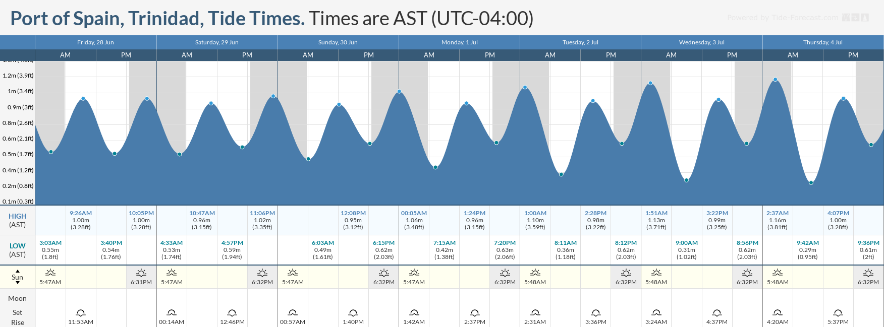
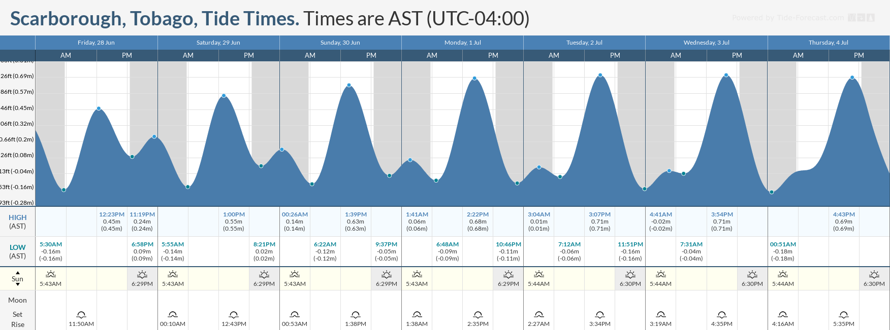
Spring tides, which are higher-than-usual high tides and lower-than-usual low tides, are forecast to begin on Tuesday. Everyone will need to exercise caution, particularly during high tide periods.
Rip currents always pose a hazard on the nation’s beaches. If caught in a rip current, swim perpendicular to the current (parallel to the shore). Mariners, especially small craft operators, should ensure their vessels are securely anchored or docked, as choppy/breaking wave conditions may drag the vessel onto the ocean floor or reefs in shallow waters or even break anchorage/mooring.


