Thunderstorms are no stranger to Trinidad and Tobago, occurring year-round. These storms produce some of our highest localized rainfall with lightning and gusty winds, particularly during the Wet Season, during the latter half of the year.
The Life Cycle of a Thunderstorm
Stage 1: Developing
Thunderstorms are developed through convection (warm air rising, cool air sinking). When conditions are favorable, and there is a triggering mechanism (more on this later) for warm, moist air to rise, this starts developing a cumulus cloud.

As the moisture cools at a higher altitude, the water vapor condenses into liquid, and heat is released. This is where the cumulus cloud is visible. However, in favorable conditions at the low, mid, and upper levels of the atmosphere, the heat warms the air, causing it to become less dense than the surrounding drier air and rise in what will now be called an updraft. This is the beginning of the convective process.
As the air rises, a low pressure aloft (above the ground, in the atmosphere) develops beneath the cumulus cloud or the forming thunderstorm.
In a typical thunderstorm, approximately 500 million kilograms of water vapor are lifted into the Earth’s atmosphere.
Triggering Mechanisms
One of the simplest triggering mechanisms is the sun heats the surface of the land, and a runway convective process causes a warm updraft and a cool downdraft to occur. This is more typical of showers across Trinidad and Tobago. We usually have a bit more going on at the surface and aloft to trigger and sustain these heat engines in thunderstorms.
Sea Breeze Convergence
This is the most common trigger during the wet season and days when a light wind regime is in place across Trinidad.
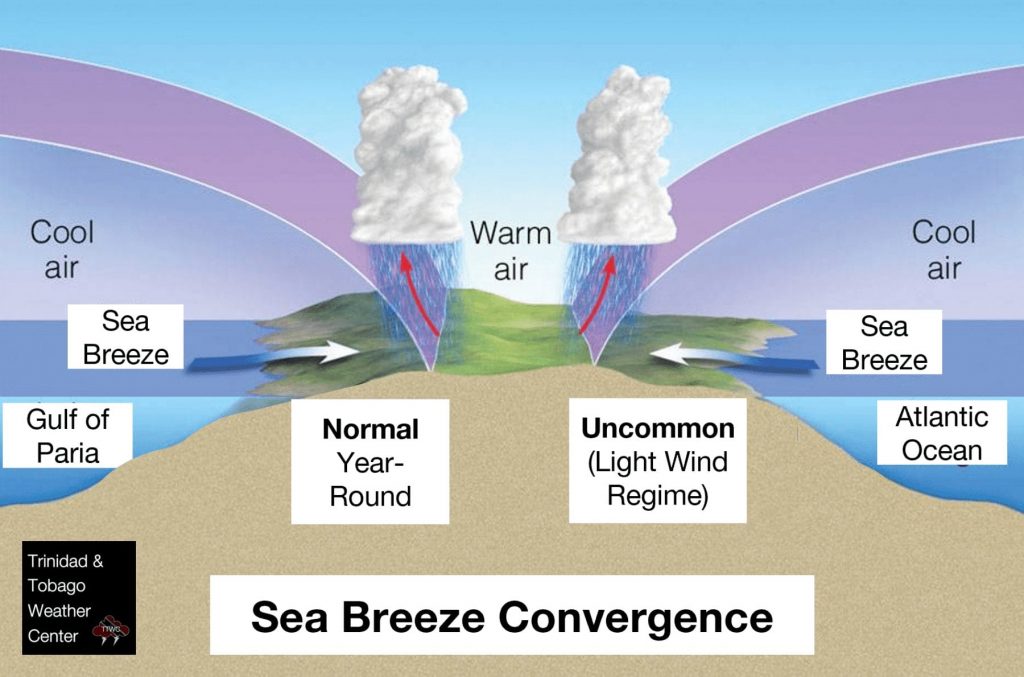
The entire process begins as soon as the sun rises. Very slowly, the sun starts to heat the land surface. The existing air over the land surface warms, and the air rises. As the air over coastal areas rises, cooler air from the surrounding water bodies moves in to replace the rising pocket of air near the surface.
This generally occurs across Western Trinidad with winds from the Gulf of Paria year-round when moisture is present, Southern Trinidad with winds from the Columbus Channel during the wet season, and Eastern Trinidad with winds from the Atlantic Ocean when the overall wind regime is light.
For the Gulf of Paria and Western Trinidad, during the afternoon hours, the sea breeze from the Gulf of Paria and prevailing easterly winds meet aloft, right over parts of Western Trinidad. When two air masses from opposite directions collide, it forces air upwards. This is called a convergence zone.
The converging air masses contain water vapor collected from the Atlantic and the Gulf. As the air rises, it cools, and water vapor condenses into water droplets, forming clouds and eventually showers and thunderstorms.
Orographic Precipitation
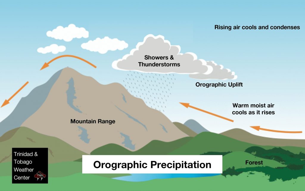
Orographic lift occurs when an air mass is forced from a low elevation to a higher elevation as it moves over rising terrain. As the air mass gains altitude, it quickly cools down, which can create showers and thunderstorms, or in some cases, enhance already existing convection.
In Trinidad, this tends to occur when winds are from the south. Winds from the surface, heated as it moves across the terrain of Trinidad, are forced upwards by the Southern, Central, and predominantly Northern Range. In Tobago, this occurs when moisture moves off the Atlantic Ocean and is forced upwards by the island’s Main Ridge.
This can also cause the mixing of stronger winds at height down towards the surface and aid in the development of higher rainfall-producing showers and thunderstorms.
Stage 2: Mature
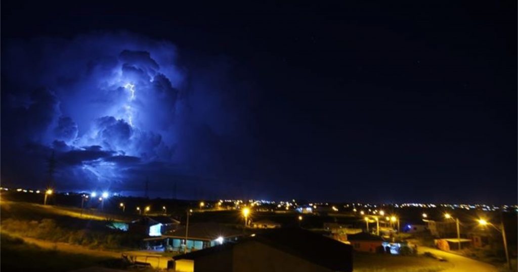
Thunderstorms at this point can produce heavy rain, possible hail, strong winds, severe lightning, and even tornadoes.
At this stage, the warmed air continues to rise until it reaches an area of warmer air and can rise no farther. This is considered a “cap” and usually occurs in the troposphere.
The air (and cloud mass) is then forced to spread out, giving the storm a characteristic anvil shape that we see in stronger thunderstorms. The resulting cloud is called cumulonimbus incus.
In typical convective showers and ordinary thunderstorms, moisture (water droplets) freeze as they rise, become ice particles, and coalesce, making the now-suspended chunks of ice fall. As these ice particles fall, they melt and become rain. However, when the updrafts (rising air) are particularly strong, the ice particles become so large that they do not melt completely when falling and fall as hail.
While updrafts are still present, the falling rain (or hail) drags the surrounding air, creating downdrafts. The simultaneous presence of both an updraft and a downdraft marks the mature stage of the storm and produces cumulonimbus clouds.
Stage 3: Dissipation
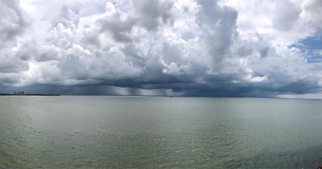
The downdraft dominates the thunderstorm at this stage, weakening it as time progresses. In Trinidad and Tobago, particularly during the rainy season and in the afternoon, if there is little wind shear, the storm will rapidly enter the dissipating stage and ‘rain itself out’ in 20-30 minutes.
When a thunderstorm reaches its dissipation stage, the downdraft will push down out of the thunderstorm, hit the ground, and spread out. This phenomenon is known as a downburst. The cool air carried to the ground by the downdraft cuts off the inflow of the thunderstorm, the updraft disappears, and the thunderstorm dissipates.
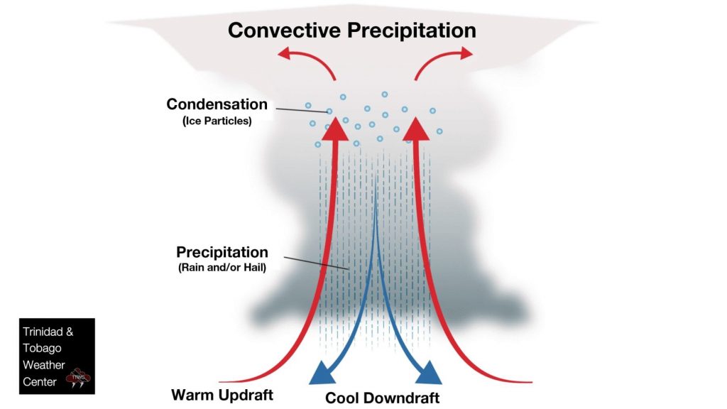
Thunderstorms in an atmosphere with virtually no vertical wind shear (where the wind changes speed or direction with height) weaken when they send out an outflow boundary in all directions. The outflow quickly cuts off its relatively warm, moist air inflow and kills the thunderstorm’s further growth.
However, if there is sufficient change in wind speed or direction, the downdraft will be separated from the updraft, and the storm may become a supercell, where the mature stage can sustain itself for several hours.
Thunderstorm Classifications
In Trinidad and Tobago, we experience three types of thunderstorms (in order of most common to rarest): single-cell, multi-cell (squall lines such as those in feeder bands from tropical cyclones), and supercell thunderstorms.
Single-cell Thunderstorms
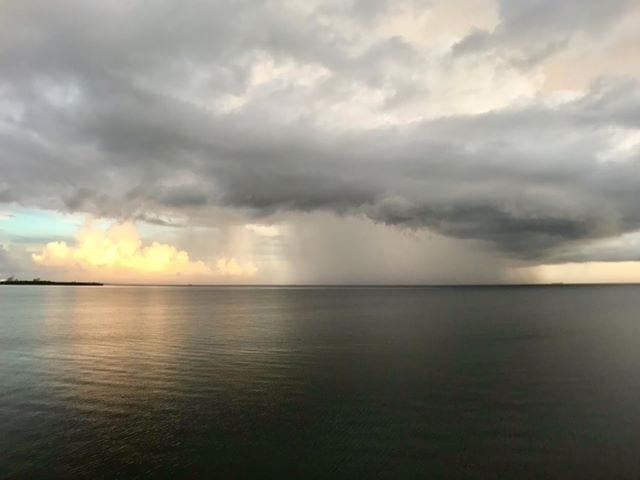
These are our most common thunderstorms in Trinidad and Tobago. They typically occur during the wet season and can be called “popcorn” convection.
They are small, brief, and mostly weak storms that grow and die within 60-90 minutes. These storms are typically driven by heating on a hot afternoon and tend to favor the Northern and Western halves of Trinidad.
These thunderstorms typically produce locally heavy rainfall that triggers street or flash flooding, gusty winds, frequent thunder and lightning, and reduced visibility.
Multi-cell Thunderstorms
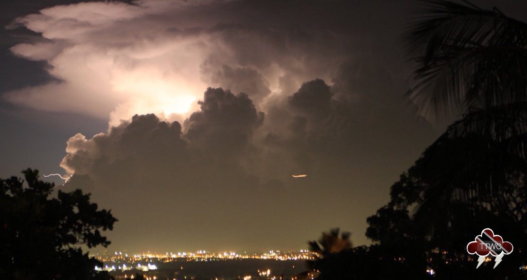
This is another common thunderstorm in which new updrafts form along the leading edge of rain-cooled air (the gust front). Individual cells usually last 30 to 60 minutes, while the system as a whole may last for many hours.
Multicell storms may produce heavy rainfall that triggers street or flash flooding, gusty winds, frequent thunder and lightning, and reduced visibility. These cells can also support hail and brief tornadoes.
Squall Lines
These are a type of multi-cell thunderstorms or can also be a multi-cell line of showers that are often accompanied by “squalls” or brief periods of high wind and heavy rain. These types of showers and thunderstorms tend to pass quickly and are less prone to producing tornadoes – but not impossible.
We frequently see this type of activity in and around tropical storms and hurricanes.
Bow Echos
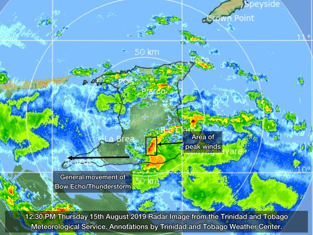
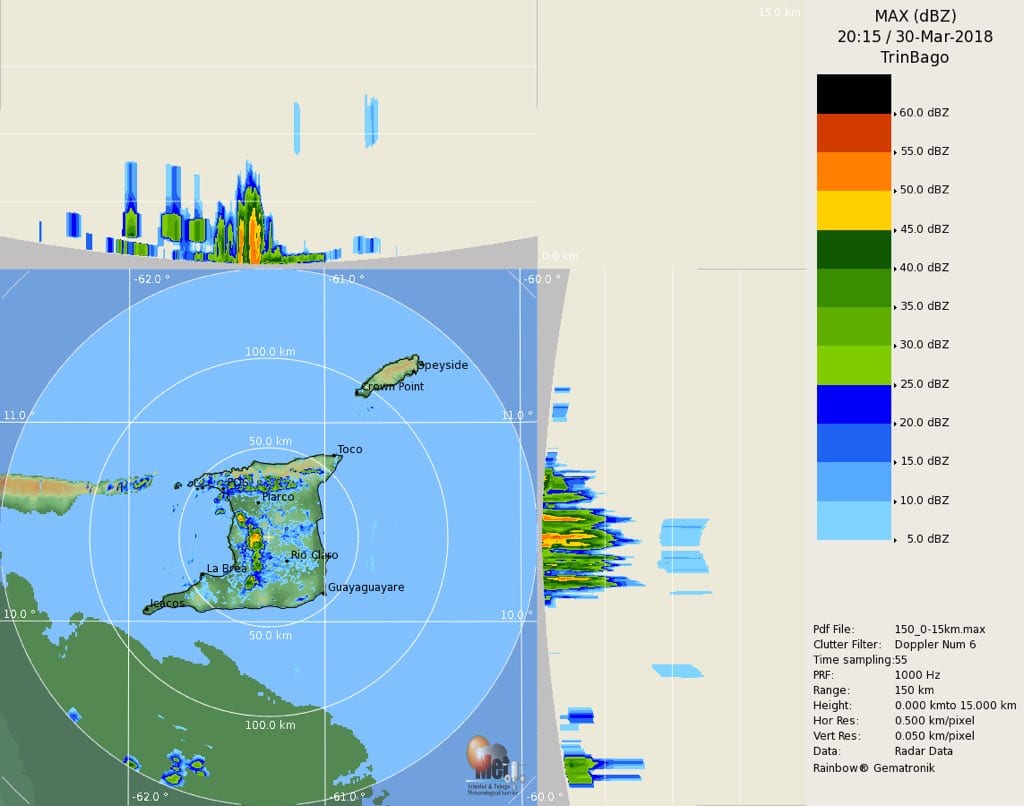
A large thunderstorm can form into a Mesoscale Convective System, known as a bow echo, because of its characteristic bow shape on radar displays.
On radar, a bow-echo looks like a comma, with a round head on one end and a tail on the other. Because in Trinidad, our weather moves from the east to the west (generally), this signature looks like a vertically and horizontally flipped comma.
The leading edge has a sharp reflectivity gradient (oranges, reds, and black on the above radar image), and there are notches (of dry air) dug into the weak reflectivity gradient on the trailing edge.
A bow echo is a radar signature of a squall line or dissipating thunderstorm that “bows out” as winds fall behind the line of showers/thunderstorms or squall line. A strongly bowed echo may indicate high winds, particularly in the middle of the line, where storms are moving forward the fastest.
Sometimes, the periphery of the bow echo, to the north and south, becomes dominant over time, gradually evolving into a comma-shaped storm complex.
Supercell Thunderstorms
Supercell thunderstorms are long-lived, highly organized, and powerful systems, lasting longer than 1 hour with a tilted and rotating updraft. These types of thunderstorms are uncommon in Trinidad and Tobago, generally smaller than supercells that frequent North America.
The rotating updraft can be as large as 10 miles in diameter and up to 50,000 feet (15 kilometers) tall. This type of activity can be present between 20 to 60 minutes before a tornado forms. A tornado is essentially an extension of this larger rotation. Most large and violent tornadoes originate from supercells.
There are other types of convective systems such as a mesoscale convective complex, a mesoscale convective vortex, and a derecho. These systems typically occur in the mid-latitudes like the United States and Europe. There are few records of these systems in Trinidad and Tobago.
Thunderstorm Frequency in T&T
Thunderstorms occur throughout the world, even in the polar regions, with the greatest frequency in tropical rainforest areas, where they may occur nearly daily. Any area in Trinidad can experience, on average, 30 to 40 thunderstorms annually. On rare occasions, as many as two to three a day in a given area. At any given time, approximately 2,000 thunderstorms are occurring on Earth.
During the wet season, thunderstorms generally occur predominantly in the late morning through the afternoon across the western half of Trinidad.
Thunderstorms can be abundant when particular weather features traverse the region – tropical waves, tropical cyclones, surface troughs, mid-, and upper-level troughs, and the Intertropical Convergence Zone.
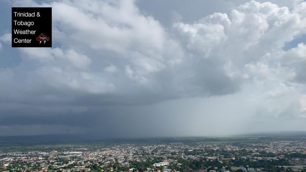
Thunderstorms bring most of our rainfall and nearly all of our street/flash flooding events. Torrential downpours can produce upwards of 20-30 millimeters of rainfall within an hour.
In addition, these thunderstorms can produce severe winds up to and in excess of 65 KM/H across localized areas of the country.
Stationary thunderstorms, such as those that caused the Divali 2017 floods, can produce upwards of 100 millimeters in one to two hours.
Thunderstorms can last from 30 minutes to as long as two hours, depending on the speed of low to mid-level winds. More prolonged thunderstorms begin to trigger different types of flooding – street, then flash, and lastly, riverine flooding.
During the Wet Season and the Atlantic Hurricane Season, tropical waves gradually become stronger, and the ITCZ may linger across the region for prolonged periods. Showers resulting from daytime heating and sea breeze convergence will become more common.
Thunderstorm Forecasting
Forecasters rely on data and numerical weather prediction models run by supercomputers globally to determine whether conditions will be suitable for thunderstorm development.
Models are designed to calculate what the atmosphere may do at specific points over different spatial scales from the earth’s surface to the top of the atmosphere.
One integral data collection points are weather balloons (atmospheric soundings) launched around the globe two times daily. In Trinidad and Tobago, these soundings are done at 7:00 AM and 7:00 PM by the Trinidad and Tobago Meteorological Service at Piarco. Special soundings can also occur due to requests by the National Hurricane Center ahead of or during a tropical cyclone or in the United States ahead of or during a severe weather event.
This is in addition to data gathered from satellites, aircraft, ships, temperature profilers, and surface weather stations.
The models start with these current weather observations and attempt to predict future weather using physics and dynamics to mathematically describe the atmosphere’s behavior. The predictions are usually output in text and graphics.
Thunderstorm Detection
Satellite
Weather satellites are some forecaster’s best friends. Most areas of Earth are covered by several geostationary satellites, taking images of Earth from thousands of kilometers away at regular intervals.
Due to advancements in technology, Trinidad and Tobago can get new satellite images as frequently as every 5 minutes from the GOES-East (GOES-16) and GOES-West (GOES-17) satellites. More incredibly, we can also get up to the minute lightning data from the Global Lightning Mapper instrument onboard these satellites. In exceptional circumstances, we can also get up to the minute satellite imagery for our region, usually when a tropical cyclone is nearby.
Generally, satellites take pictures of Earth at regular intervals from space, telling us where clouds are. Meteorologists and forecasters watch these pictures over time to watch for rapidly growing clouds, a clue to a possible thunderstorm. Satellites also can tell us the temperature of the clouds. Clouds with cold tops are usually very high up in the atmosphere could mean the cloud is tall enough to be a thunderstorm. Lightning data from newer satellites support the “thunderstorm” designation.
Radar & Lightning Detectors
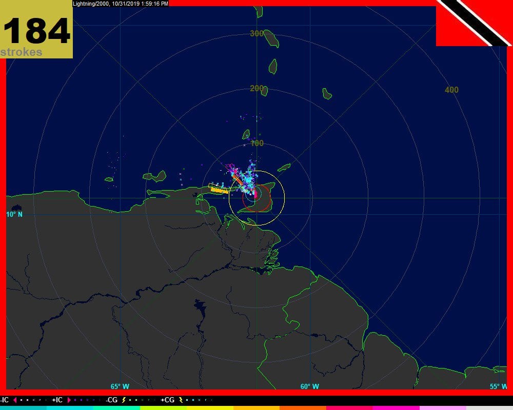
Doppler radar sends out electromagnetic wave fields that can be reflected to the radar by things in the air like precipitation. The amount of energy reflected can tell us how heavy the rain might be or whether there is hail.
Advanced Doppler radars can also show us how the wind is blowing near and inside the storm. This helps understand what kinds of hazards the thunderstorm might have (tornado, microburst, gust fronts, etc.). It also helps us understand how the thunderstorm is feeding itself.
Automated weather stations with lightning detectors or stand-alone lightning detectors can also aid in the detection of thunderstorms.
Hazards
Thunderstorms bring several hazards to Trinidad and Tobago. The most common are lightning, gusty winds, and street/flash flooding resulting from heavy rainfall.
Less commonly, we experience damaging downbursts associated with dissipating thunderstorms. Even less common are tornadoes, waterspouts, and funnel clouds. The rarest hazard for Trinidad and Tobago has been hail which is typically associated with the strongest thunderstorms in the tropics.
Frequently Asked Questions
It’s the Dry Season. Why do we have thunderstorms?
A thunderstorm can form once conditions are optimal (moisture, unstable air mass, and heat or a lifting mechanism, see Stages of a Thunderstorm above). Since these conditions, particularly ample atmospheric moisture, are predominantly present during the Wet Season, thunderstorm activity becomes more common from May through December.
What is a severe thunderstorm?
A thunderstorm is classified as “severe” when it contains one or more of the following: hail one inch (2.54 cm) or greater, winds gusting in excess of 50 knots (92.6 KM/H), or a tornado, based on the United States definition.
Given how rare these types of thunderstorms are in our region – we classify a severe or strong thunderstorm as one that produces any of the following:
- Damaging wind gusts exceeding 55 KM/H;
- Frequent lightning (more than 30 cloud-to-ground strikes within a 10-minute period);
- Hail (of any size);
- Rainfall of more than 50 millimeters or more within an hour or exceeding 75 millimeters or more within three hours;
- The sighting of a funnel cloud or touchdown of a waterspout/tornado associated with the thunderstorm.
How many thunderstorms are there?
Worldwide, there are an estimated 16 million thunderstorms each year, and at any given moment, there are roughly 2,000 thunderstorms in progress. Any area in Trinidad can experience, on average, 30 to 40 thunderstorms annually. On rare occasions, as many as two to three a day in a given area.
Where and when are thunderstorms most likely?
Thunderstorms are most likely in the Wet Season across Trinidad and Tobago, mainly during the afternoon and evening hours, but they can occur year-round and at all hours.
Thunderstorms tend to favor the Western halves of Trinidad and Tobago during the late mornings through the late afternoons due to the abundant heat present and sea breeze convergence (as the lifting mechanisms).
A thunderstorm is ongoing, producing gusty winds, street/flash flooding, and frequent lightning. Why aren’t we under an alert/watch/warning?
Advisories (in this case, an Adverse Weather Alert/Watch/Warning) would originate from the Trinidad and Tobago Meteorological Service. These advisories are issued based on the risk to public safety, livelihoods, and property for a given geographical area.
However, these advisories are only issued when the threats are widespread, instead of the typical isolated activity we experience during the Wet Season. If an advisory was issued for each thunderstorm, not only is this difficult to do with any appreciable lead time, but we would potentially be under an alert throughout the entire Wet Season, which reduces the likelihood of people heeding the warnings.
In the same way not every tropical wave brings inclement weather or requires a name to bring impactful weather to T&T, not every thunderstorm requires an alert for us to be prepared.


