


The wet season, sometimes called the rainy season, in Trinidad and Tobago is an annual period of higher-than-average rainfall. Our wet season can start as early as the beginning of May and as late as June. This wetter-than-average period continues through December and into January of the subsequent year.
According to the Trinidad and Tobago Meteorological Service, “A modified moist equatorial climate characterized by low wind speeds, hot, humid days and nights, a marked increase in rainfall which results mostly from migrating and latitudinal shifting equatorial weather systems, symbolizes the wet season during June to December. Late May and December are considered as transitional periods to the wet and dry seasons, respectively.”
The Wet Season Declaration
There is no fixed date for the beginning of the wet season. Historically, April and May are the transitional months into a wetter climate. The Trinidad and Tobago Meteorological Service will officially declare the start of the annual wet season once one of two features moves across the country, triggering rainfall, as explained below.
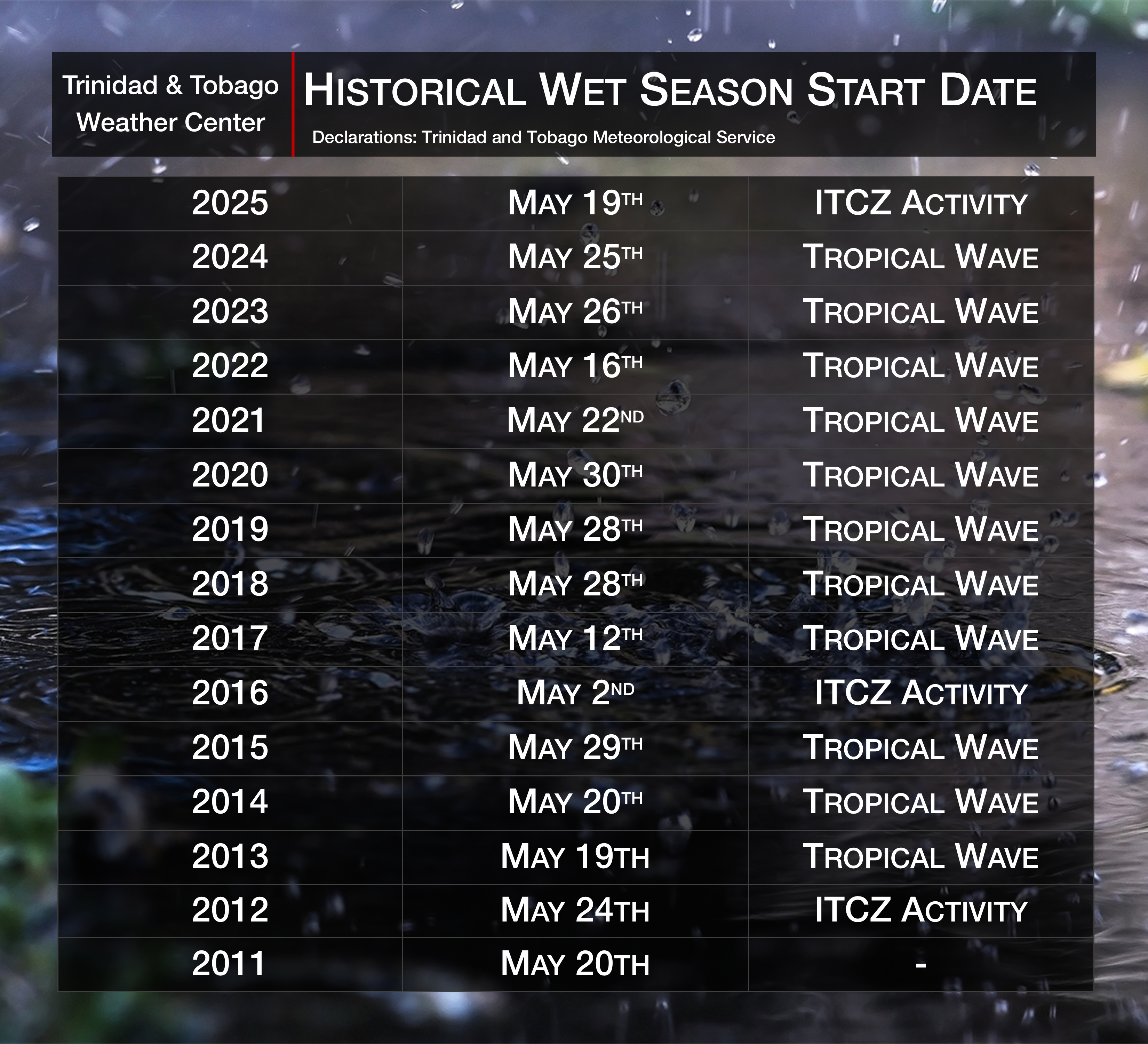
Once the assessment of criteria necessary for the onset of the wet season has been met and is entrenched, the Trinidad and Tobago Meteorological Service will release a declaration. So, what features trigger the start of the wet or rainy season?
Rainfall-Triggering Features to Declare the Wet Season
The Passage of a Tropical Wave
A tropical wave is a type of trough, an elongated area of relatively lower air pressure that is typically oriented north to south and moves east to west across the tropical easterlies. Tropical waves are also called African Easterly Waves or Tropical Easterly Waves. These features have several points of origin, and several different meteorological offices characterize them differently.
Since the Trinidad and Tobago Meteorological Service declares the beginning of the wet season, the distinction of the passage of a tropical wave matters for the declaration. However, the National Hurricane Center Tropical Analysis and Forecast Branch’s Unified Surface Analysis is an excellent tool.
Tropical waves usually bring deep, tropical moisture and favorable atmospheric conditions for scattered to widespread showers and isolated to scattered thunderstorms. This somewhat prolonged rainfall event triggers the wetter-than-average period across the islands.
Read More

Tropical Waves
The Influence of the Intertropical Convergence Zone
The Intertropical Convergence Zone (ITCZ) is a band of low pressure that usually circles the globe where northeasterly and southeasterly trade winds meet. Satellite imagery generally shows this area as a narrow band of cloudiness, showers, and thunderstorms.
The ITCZ brings increased moisture, which fuels overall cloudiness, showers, periods of rain, and thunderstorms. Since the ITCZ brings prolonged rainfall, ITCZ events tend to bring multi-day rainfall events that trigger street, flash, and riverine flooding. Due to saturated soils, landslides are also possible. Frequent lightning and gusty winds are also a consequence of the ITCZ-thunderstorm activity.
With light and variable winds, conditions become favorable for funnel clouds, waterspouts, and even tornadoes, albeit rare.
Read More

The Intertropical Convergence Zone (ITCZ)
Wet Season Impacts
It is important to note that the wet season is never without sunshine. Periods of dry weather or dry spells (a long period of abnormally dry weather that is shorter and less severe than a drought) have occurred and will continue to occur during the wet season. If an unusually dry and sunny period occurs sometime in September or early October, the span may be called a Petit Carême. These conditions are usually brought on during the El Niño years, where conditions in the region during the wet season do not favor rainfall activity.
- Tropical Cyclones. The wet season coincides with the Atlantic Hurricane Season. Even peripheral impacts of a tropical cyclone can spell disaster for Trinidad and Tobago, with the threat to life and property.
- Flooding. With increasing rainfall and T&T’s high vulnerability to flooding, short-term to long-term inundation is expected during the wet season. This can range from street flooding to riverine flooding.
- Gusty Winds. As thunderstorm activity increases, the potential for gusty winds, particularly damaging gusty winds, increases. This can cause knock-on effects such as property damage, downed trees, and power outages.
- Landslides. With more saturated soils, particularly in elevated areas, landslides are possible. Chances for landslides increase during multi-day rainfall events.
- Funnel Clouds, Waterspouts, and Tornadoes. With conditions favorable for thunderstorm development and light winds when the ITCZ affects the region, dynamics are favorable for this kind of activity.
- Hot Temperatures. Beginning in March and running through October typically designates our local heat season, with peak temperatures in May and a secondary peak in October. In Trinidad, we classify a hot day as temperatures recorded greater than 34.0°C, while in Tobago, a hot day is classified as 33.0°C. During the dry season, hot days can become frequent. Prolonged hot days can result in heat advisories, which the Trinidad and Tobago Meteorological Service has issued in the past, including Hot Spell Alerts and Hot Spell Watches. Based on historical issuance, these advisories are only issued if there is the risk of temperatures exceeding 34.0°C during the day and minimum nighttime temperatures above 24.0°C on at least 3-5 days.
- Heat Stress and Heat Stroke. Excessive heat can increase the chances of heat stress on persons with heat-sensitive ailments and heat-exposed livestock, pets, and other animals—practice heat safety.
- Periodic Variations in Air Quality. While the threat of fires and blowing dust decreases during the wet season, severe surges of Saharan Dust following tropical waves can significantly reduce air quality across the region.
- Water Storage. Increased rainfall will improve water reservoir levels and increase groundwater recharge, surface water flows, and water availability; however, water reservoirs in areas with prior rainfall shortages may require extended periods of heavy rainfall to recover fully.
- Agricultural Losses. With the threat of flooding, entire fields of crops can be lost to inundation, with land unusable for a prolonged period. Heat stress can occur with crops and livestock. Increased rainfall and warm and humid conditions promote the rapid multiplication of some agricultural pests, diseases, and fungal growth.
- Increase in Mosquitoes and Mosquito-Borne Diseases. An increase in surface water ponding increases mosquito breeding sites and the chance of more incidences of vector-borne diseases.
- Hazardous Seas. Strong low-pressure systems (tropical cyclones) in the North Atlantic Ocean can cause hazardous seas. These can range from long-period swells from distant systems to storm surges and wind-driven rough seas from closer systems, affecting marine activities and coastal communities.
What Should You Do?
During the wet season, the public is always advised to monitor weather updates and forecasts from trusted sources, prepare your home for potential flooding if you live in a flood-prone area, restock your emergency supplies, and ensure your family or personal emergency supply is in a state of readiness.