Throughout the year, Trinidad and Tobago experience rough sea conditions for many reasons. These rough seas impact the lives of mariners and can translate into hazardous conditions nearshore along bays and beaches, and can even contribute to coastal flooding and erosion.
Hazardous Seas Causes & Frequency
Most waves across Trinidad and Tobago are wind-driven. This means that the local prevailing wind generates waves. These waves would vary in size according to the length of time a particular wind has been blowing, the fetch (the distance the wind has blown over the sea), and the water depth.
Hazardous seas across Trinidad and Tobago’s coastal waters mainly come from three sources; long-period swells from distant weather systems, strong low-level winds agitating sea surface conditions, and wind-driven waves from local weather systems such as strong thunderstorms or tropical cyclones.
Long Period Swells
Large weather systems (extra-tropical or tropical low-pressure systems) with sustained winds can blow across long fetches and travel thousands of kilometers from their point of origin.
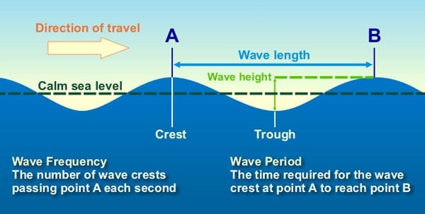
Swells are also different from regular waves as it has a longer period. The period of a wave is the time between the crests or peaks of a wave, usually measured in seconds. For a swell to be considered a long period, the wave period is typically greater than 11 seconds.
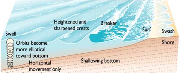
In deep, open water, swells present less of a hazard to most mariners than wind waves. Swells become more dangerous as it moves into shallow waters because of a process called shoaling. This allows swells to become steeper and taller. These swells can double in height as they move into shallow water and break in open waters.
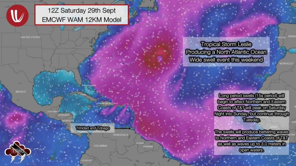
Long period swells during December through May tend to originate from strong extra-tropical low-pressure systems or winter storms moving off the Eastern Coast of the United States. During an El Niño year, when winter storms take a more southern track across the United States, Trinidad and Tobago typically experience increased swell events. From May through November, however, long period swells in the Atlantic Ocean tend to originate from passing tropical cyclones across the Atlantic Basin.
Strong Low-Level Wind-Generated Waves
Predominantly during the dry season, between the end of December through mid-May, Central Atlantic high-pressure systems dominate across the Atlantic Basin. This weather feature is responsible for suppressed rainfall across the Eastern Caribbean and breezy conditions with prevailing winds generally from the northeast to the east.
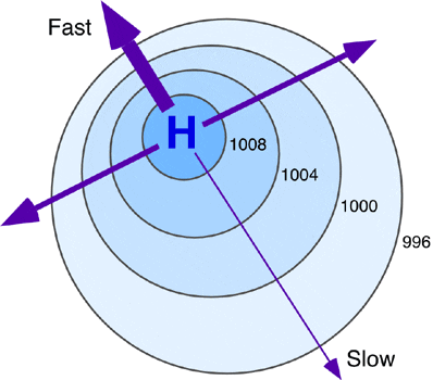
Association between wind speed and distance between isobars (lines of equal pressure). In the illustration above, thicker arrows represent relatively faster winds. Credit: Physical Geography
At times, the pressure gradient tightens, meaning low and high-pressure areas are close to each other. This tight pressure gradient can generate strong low-level winds that blow across the Atlantic Ocean, bringing gusty winds on land and at sea but accompanying rough seas (waves ≥ 2.5 meters).
Thunderstorms & Tropical Cyclone Generated Waves
A tropical cyclone is a strong, closed low-pressure system with strong winds, showers, and thunderstorms. (you can read more about tropical cyclones here.) Tropical cyclones in the Atlantic Basin usually occur between June 1st and November 30th, but out-of-season storms have happened in the past.
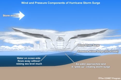
The wind associated with a tropical cyclone blows over a large fetch and can cause waves of significant height to impact coastlines due to water piling up along coastlines. This can cause coastal flooding of tsunami-like proportions.
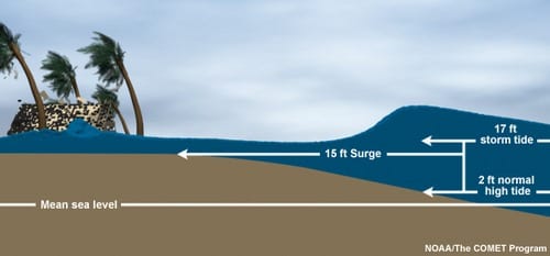
The two main meteorological factors contributing to a storm surge are a long fetch of winds spiraling inward toward the storm and a low-pressure-induced dome of water drawn up under and trailing the storm’s center.
Thunderstorms, particularly severe thunderstorms, can produce locally rough seas as strong downdrafts can agitate the sea surface and cause damaging waves out at sea. In rare cases, in fast-moving severe thunderstorms, meteotsunamis can also occur.
Hazardous Seas Monitoring & Forecasting
Hazardous seas are fairly predictable events in this modern era as forecasters have a wide array of satellite data (RapidSCAT, ASCAT, WindSat, Oceansat-2, SMAP, SSM/I, GCOMW1-AMSR2 Radiometer) and a network of buoys and ship reports relaying sea conditions in a near real-time basis.
This collection of data is then fed into several waves and swell models, most notably the ECMWF Wave Model (WAM) and the GFS Wavewatch III Model. Forecasters can combine all of these pieces of information and issue forewarning.
In Trinidad and Tobago, the Trinidad and Tobago Meteorological Service issues Hazardous Seas Alerts, Watches, and Warnings at different levels (yellow, orange, and red) depending on the severity of the conditions.
Most countries in the Caribbean and internationally follow a rigid marine warning system, issuing small craft cautions, advisories, and warnings based on expected wind speeds and sea wave heights for mariners and high surf advisories and warnings based on wave heights for beachgoers and coastal communities.
Several wave heights can be used in wave forecasts. However, most meteorological offices use total or significant wave heights.
The significant wave height is the average height of the top one-third of all wave heights. About 14% of waves (1 in 7) will be higher than the significant wave height. The most frequent wave height is 0.64 of the significant wave height.
Maximum waves are twice the significant wave height. It is normal to expect a wave of twice the height of the significant wave about three times in 24 hours. This means you need to be prepared for a wave of this height before heading out to sea!
For example, if the forecast calls for waves of 2.0 meters in open waters, this is the significant wave height. This would mean that the most frequent wave height you would experience at sea would be approximately 1.28 meters. This also means that the maximum wave height you can experience at sea would be 4.0 meters. You need to be prepared for a wave of this height before heading to sea!
The sea forecast, i.e., the significant wave height, takes into account the combined wind-generated waves and swells using the following table:
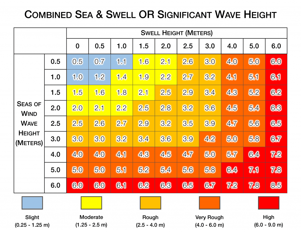
In sea forecasts, seas can be qualitatively described as calm, slight, moderate, rough, and very rough to high in rare instances. What do these terms actually mean? See the below table for more information.
| Description | Height (Meters) |
Effect | WMO Sea State Code |
| Calm (Glassy) | 0 | No waves breaking on the beach | 0 |
| Calm (Rippled) | 0 – 0.1 | No waves breaking on the beach | 1 |
| Smooth | 0.1 – 0.5 | Slight waves breaking on the beach | 2 |
| Slight | 0.5 – 1.25 | Waves rock buoys and small craft | 3 |
| Moderate | 1.25 – 2.5 | Sea becoming furrowed | 4 |
| Rough | 2.5 – 4 | Sea deeply furrowed | 5 |
| Very Rough | 4 – 6 | Sea much disturbed with rollers having steep fronts | 6 |
| High | 6 – 9 | Sea much disturbed with rollers having steep fronts (damage to foreshore) | 7 |
| Very High | 9 – 14 | Towering seas | 8 |
| Phenomenal | 14+ | Precipitous seas (experienced only in tropical storms or hurricanes) | 9 |
Hazardous Seas Effects
Injuries or Loss of Life. For beachgoers and coastal communities, hazardous waves and swells near or onshore produce dangerous rip currents that can carry even the strongest swimmers out to sea. High surf can also knock spectators off exposed rocks and jetties. Because of these hazardous conditions, beaches can be closed to the public. Small craft may be difficult to navigate for mariners, and waves can be hazardous to small craft. Inexperienced mariners, especially those operating smaller vessels, should avoid navigating in these conditions.
Beach Erosion. Swells can produce large breaking waves in nearshore and onshore areas. These waves can cause severe erosion along coastal communities. This has been the case in Trinidad and Tobago along Tobago’s Atlantic Coastlines, Mayaro, Manzanilla in Eastern Trinidad, and Cedros and Icacos in Southwestern Trinidad.
Coastal Flooding. Particularly during high tides, large waves can produce localized coastal flooding. Seawater can also splash onto low-lying roadways such as Mosquito Creek and the Manzanilla-Mayaro Road.
Economic Losses. Hazardous seas can close beaches and shut down most marine activities such as fishing and marine recreation. In severe conditions, coastal flooding and/or large battering waves can cause significant damage to property and boats in coastal communities. This has further consequences for businesses and economies that rely on tourism, fishing, etc.
Environmental Impacts. In turbulent and rough seas, sensitive coral reefs can be damaged. Coastal floods can cause saltwater intrusion into farmland and the water table, disrupting potable water from desalination.
Major Hazardous Seas Events
Hazardous Seas Safety
Rip currents are powerful channels of water flowing quickly away from the shore, which occur most often at low spots or breaks in the sandbar and near structures such as groins, jetties, and piers. If caught in a rip current, relax and float. Don`t swim against the current. If able, swim in a direction following the shoreline. If unable to escape, face the shore and call or wave for help.
Secure property. Hazardous sea events are fairly well forecasted. If hazardous seas are forecast for your location, secure small crafts if you own a marine vessel. If you live on a waterfront property, sandbagging is useful if coastal flooding materializes.
Stay out of the ocean. If you are a mariner who owns a small craft, it will be dangerous to venture into the ocean, particularly if you are inexperienced. Remember, even if the seas forecast calls for waves of 2.5 meters in open waters, the maximum wave height is double that number, i.e., 5 meters. You need to be prepared for a wave of this height before heading out to sea! Waves of this height are capable of capsizing larger vessels. Recreational boaters should remain in port or take shelter until waves subside. Commercial vessels should prepare for rough seas and consider remaining in port or taking shelter in port until hazardous seas subside.
Stay away from beaches or entering the water. If you consider visiting the beach during a period of hazardous seas, don’t! Beaches can be closed. Large breaking waves can knock you down and cause serious injuries. Rip currents can be life-threatening. Your safest option is to wait until seas return to normalcy.


