Hail in Trinidad and Tobago is incredibly rare, even with our frequent thunderstorms year-round. According to the American Meteorological Society, hail is defined as precipitation in the form of balls or irregular lumps of ice, always produced by convective clouds, nearly always cumulonimbus. Hail can damage aircraft, homes, and cars and can be deadly to livestock and people.
Hail Formation

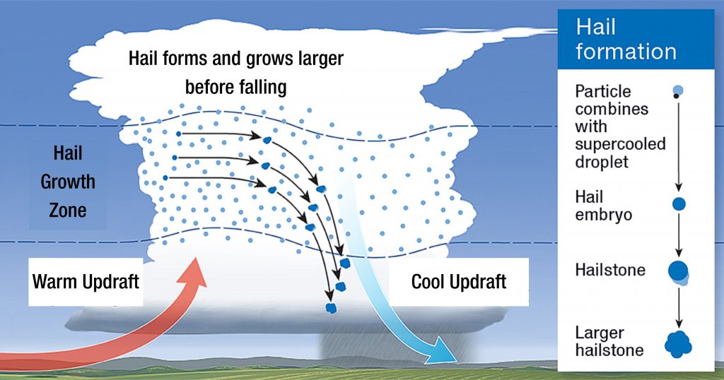
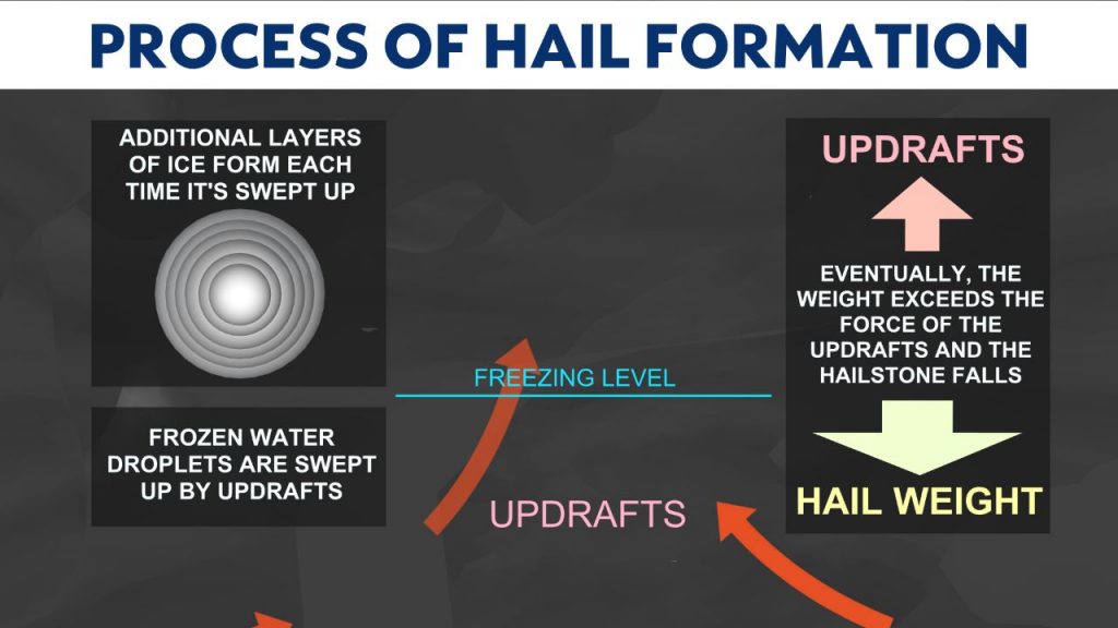
Hailstones are clumps of layered ice forming in the rising air within thunderstorms, known as updrafts.
Hailstones start as water vapor condensing into tiny water droplets that exist inside the updraft. Temperatures near the top of thunderstorm clouds are very cold, dropping to around –50 to –60°C, even though we live in the tropics.
As the droplets are swept upwards into this very cold environment, they become ‘super-cooled’ (colder than 0 °C, but still liquid). They freeze into small ice balls (called ‘hail embryos’) if they come into contact with tiny particles in the air, such as a speck of dust or dirt or a salt crystal.

Growth into a fully-fledged hailstone happens in the ‘hail growth zone,’ where the updraft air temperature is –10 to –25°C. Here, hail embryos collide with super-cooled water droplets, causing them to freeze on impact. Once the hailstones have collided with enough of these droplets, building up in size, they become heavy enough for gravity to take over and begin to fall.
Hail Forecasting & Detection in Trinidad
Severe thunderstorms, or hailstorms, favor Trinidad versus Tobago due to our higher temperatures and frequent sea breeze convergence.
For severe thunderstorms or hailstorms to occur, little to no wind and a cloudless morning are required. Surface temperatures will soar above normal, with the sun bearing down on our land throughout the sunny morning. But well above normal, in the range between 35°C to 38°C.
This is what we call low-level convergence and sea-breeze convergence induced by daytime heating. Hot, rising air across the island will cause cooler but moist air from the Gulf of Paria to fill its void. As the sea breeze moves onshore, it heats up and feeds the hot and rising columns of air overland.
For severe thunderstorms, the heights of these clouds can reach between 12 and 15 kilometers. Here is where the traditional hail formation takes over, as described above.
The conditions that create cumulonimbus clouds, or thunderstorms, are generally present throughout the year but favor the wet season months. Conditions that create hailstorms, however, occur primarily between August and October.
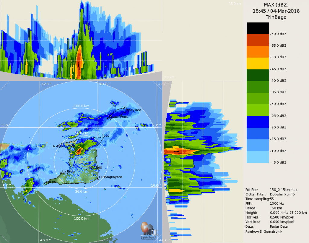
Hail can be detected using radar. On Doppler radar, hail generally sends a return signal that looks like extremely heavy rainfall.

There is no clear distinction between storms that do and do not produce hailstones. Nearly all severe thunderstorms probably produce hail aloft, though it may melt before reaching the ground.
Hail Sizes & Speed
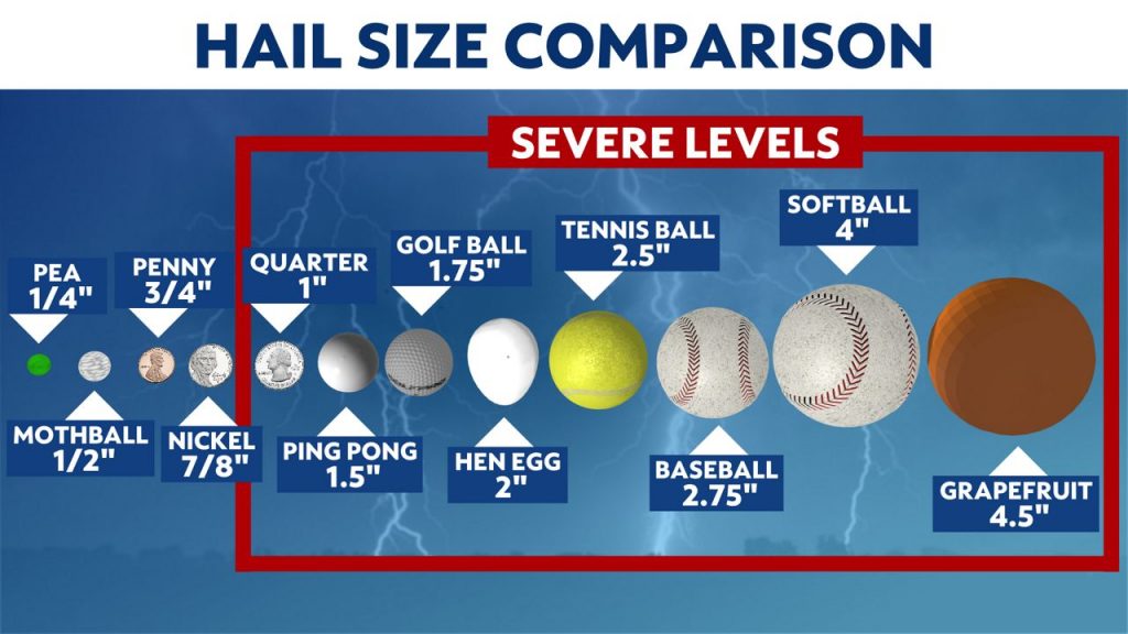
Hail size is often estimated by comparing it to a known object. Most hailstorms are made up of different sizes, and only the largest hailstones pose a serious risk to people caught in the open. When reporting hail, estimates comparing the hail to a known object with a definite size are good, but measurements using a ruler, calipers, or a tape measure are best.

The fall speed of hail primarily depends on the size of the hailstone, the friction between the hailstone and surrounding air, the local wind conditions (both horizontal and vertical), and the degree of melting of the hailstone.
Early research assumed that hailstones fell like solid ice spheres and showed very high fall speeds, even for very small hailstones. However, recent research outside of NSSL using 3-D printed casts of real hailstones suspended in a vertical wind tunnel has repeatedly shown that natural hailstones fall more slowly than solid ice spheres.
For small hailstones (<1-inch in diameter), the expected fall speed is between 9 and 25 mph. For hailstones that one would typically see in a severe thunderstorm (1-inch to 1.75-inch in diameter), the expected fall speed is between 25 and 40 mph.
In the strongest supercells that produce some of the largest hail might expect to see (2-inches to 4-inches in diameter), the expected fall speed is between 44 and 72 mph. However, these estimates are uncertain due to variability in the hailstone’s shape, degree of melting, fall orientation, and environmental conditions. However, very large hailstones (diameters exceeding 4-inches) can fall at over 100 mph.
Occurrence & Frequency in T&T
Hail is most common within continental interiors of the mid-latitudes, as hail formation is considerably more likely when the freezing level is below 11,000 feet (3,400 meters).
The movement of dry air into strong thunderstorms over continents can increase the frequency of hail by promoting evaporational cooling, which lowers the freezing level of thunderstorm clouds giving hail a larger volume to grow in.
Accordingly, hail is less common in the tropics despite a much higher frequency of thunderstorms than in the mid-latitudes because the atmosphere over the tropics tends to be warmer over a much greater altitude. Hail in the tropics occurs mainly at higher elevations.
Over the last several decades, there have also been reports of hail events in parts of Maraval, St. James, San Fernando, Cunupia, and St. Augustine.
Some of the most notable hail reports have been the August 2021 Arouca Hailstorm, the 2009 Caroni Plains Tornado, and the August 1996 Hailstorm.
The August 12th, 1996, Hailstorm
On Monday, August 12th, 1996, a severe thunderstorm produced hail across La Romain, San Fernando, and Penal. These details were confirmed by Robin Maharaj, a weather forecaster at the time, with the Trinidad and Tobago Meteorological Service.
Maharaj also added that in the 1980s, there were frequent reports of hailstones falling in the Diego Martin Valley. According to Maharaj, an expatriate family was among those who experienced it and kept some of the hailstones refrigerated. He was able to inspect them, and they were the size of mothballs (1/2 inch in diameter).
There was also a report of hail in the Valsayn area in 1994.
Note that because high surface temperatures are required to form these severe thunderstorms and hailstorms, any hailstones that make it to the surface will likely quickly melt. Sometimes, it may survive long enough to be visible.
Though hailstorms are rare for Trinidad and Tobago and the Caribbean, they have been reported in the past in Venezuela, Barbados, Jamaica, and St. Kitts, with some of the most recent events occurring in Martinique.
Hail FAQ’s
Why does the sky look green during some hail storms?
Scientists disagree on why the sky may appear green during severe weather, although there is plenty of anecdotal evidence that it can mean hail may be nearby. One theory is that large amounts of water and ice in the updrafts of a severe thunderstorm will scatter green light, making the clouds appear green.
Does a hailstorm mean there could also be a tornado?
Not always, but possibly. Since large hail often appears near the area within a thunderstorm where tornadoes are most likely to form, you should assume a tornado could be nearby and seek appropriate shelter.
Is hail dangerous to aircraft?
Yes. On April 4, 1977, a Southern Airways DC-9 crashed in New Hope, Georgia. Both engines of the plane ingested hail and lost thrust. The plane crashed onto the road and burst into flames. Two of the four crew members and 60 of the 81 passengers were killed; eight others were killed on the ground.
In recent years, there have been numerous incidents of commercial airliners being forced to land after encountering hail during flight and causing severe damage to the aircraft, including crushing the nose cone and damaging the cockpit windscreen to such an extent that pilots could no longer see through the screen.
Does it need to be cold on the ground for hail to form?
No. In Trinidad and (lesser so Tobago), surface temperatures need to be very hot to support the strong updrafts required for hail development. Hence, cold temperatures are not required at the surface to develop hail.
Hail Safety
Make a plan
A hailstorm can disrupt electrical service and is often accompanied by other severe weather events, such as hurricanes and tornadoes. Prepare your family for the hazards and inconveniences of a hailstorm by creating a disaster preparedness plan, including a disaster survival kit and an emergency evacuation plan.
Stay informed
Tune in to updates from local media, trusted sources on social media, and official sources of information.
Move inside, stay inside
Hailstones vary greatly in size, but even small ones — driven by gravity and strong winds — pose a danger to anything or anyone caught in a storm. As a storm approaches, put vehicles in the garage and bring pets inside. If you are outdoors, go indoors immediately.
Stay indoors until the storm has passed. Once you’re indoors, close all drapes, blinds, or shades to prevent broken window glass and hailstones from entering your home. If possible, move to a basement, cellar, or other building levels not directly below the roof.
If you’re on the road during a hailstorm, stay in your vehicle and slow down or stop, as roads may become slippery. Once you have pulled over safely, turn your back to the windows or cover yourself with a blanket to protect yourself from broken glass.
Protect your roof
Roof damage is a common consequence of hailstorms. Following a strong storm, you should evaluate the condition of your roof to identify any damage and prevent further deterioration.
During the storm
- Avoid finding shelter under trees or in areas like culverts that can suddenly fill with water.
- Stay indoors and away from windows, glass doors, and skylights.
- Close drapes or blinds to protect yourself from broken glass and flying debris.
- Keep pets indoors and provide shelter for farm animals.
If you’re driving
- Pull into a gas station or other covered structure.
- Pull over and angle your vehicle so that hail hits the reinforced windshield rather than the side and back windows.
- Avoid flooded roads.
After the hail stops
- If there’s a power outage, turn off electronics and appliances to avoid damage from a power surge.
- Use a flashlight instead of candles, which can be a fire hazard.
- Turn off valves, if you detect any gas leaks.
- Clean up debris and make any temporary repairs.
If a hail storm impacts your property
- Document the damage as soon as possible.
- Take photos or make a video.
- Keep records for clean-up costs complete and available to help simplify your insurance claims experience.
If you’ve ever experienced hail, let us know at [email protected]. Let us know the date, location, and any images if possible so we can build a database of severe events in T&T!


