


Tropical Wave 04 has moved across Trinidad and Tobago, bringing periods of rain, showers, and thunderstorms to the country, with heavier rainfall favoring Tobago and eastern Trinidad initially. This tropical wave (Tropical Wave 04) is the first of three features to affect the country over the next five to six days, with rounds of heavy rainfall and gusty winds forecast.
A low-level trough is forecast to move across the country on Wednesday, and Tropical Wave 05 is forecast to arrive across the country by Friday into Saturday, both bringing additional rounds of rainfall.
What you need to know
— Rainfall: Already, parts of Tobago and northeastern Trinidad have seen rainfall totals between 50 and 75 millimeters. Through Wednesday afternoon, forecast models indicate at least 20 and 50 millimeters of rainfall across most of Trinidad and Tobago, with higher rainfall totals in the eastern and southern parts of both islands, as well as isolated western coastal areas of Trinidad. However, rainfall totals nearing 100 millimeters are likely across the eastern and southern halves of Trinidad due to repeated rounds of persisting rainfall, which at times may occur in heavy showers and thunderstorms.
— Hazards: With heavy showers and thunderstorms, as well as periods of rain, many of the typical Wet Season hazards are on the table for the next five days. Street and flash flooding is likely in heavy rain, showers, and thunderstorms, accompanied by wind gusts exceeding 50 km/h, and lightning during thunderstorm activity. From this evening, as soils become increasingly saturated, landslides are possible in elevated areas. Seas may become locally rough or agitated during heavy showers or thunderstorm activity.
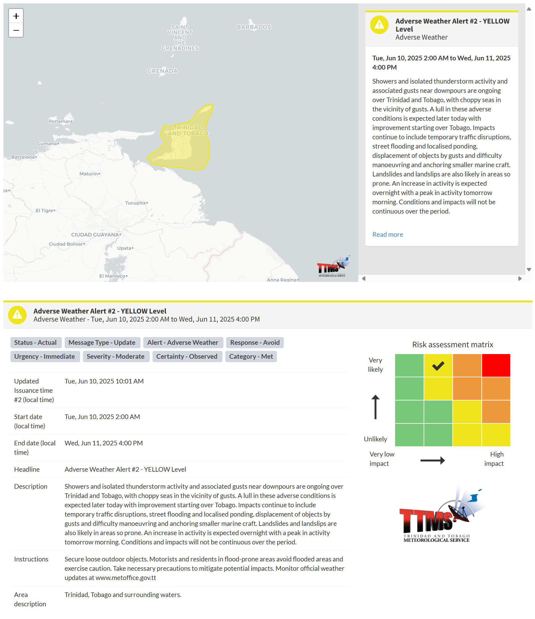
Latest Alerts

Adverse Weather Alert Discontinued For Western Trinidad
Trinidad and Tobago is NOT under any tropical storm or hurricane threat, watch, or warning at this time.
The Adverse Weather Alert
The Trinidad and Tobago Meteorological Service updated the Adverse Weather Alert (Yellow Level) on Tuesday, June 10th, 2025, at 10:01 AM for Trinidad and Tobago and surrounding waters. The alert went into effect from 2:00 AM Tuesday, June 10th, 2025, through 4:00 PM Wednesday, June 11th, 2025. Impactful weather is likely to occur beyond this alert period due to additional moisture and instability flowing across T&T, particularly with favorable low- and upper-level conditions.
According to the TTMS, this period of inclement weather is “associated with atmospheric instability expected from early morning. The most impactful weather is expected mainly over southern and eastern offshore areas tomorrow morning, slowly extending across Trinidad and Tobago.”
This “alert” status considers the possibility of the event occurring. This adverse weather event has been observed, and the following are very likely/observed, according to the TTMS:
- Showers and isolated thunderstorm activity, along with associated gusts near downpours, are ongoing over Trinidad and Tobago, accompanied by choppy seas in the vicinity of the gusts.
- A lull in these adverse conditions is expected later today, with improvement starting over Tobago. Impacts continue to include temporary traffic disruptions, street flooding and localised ponding, displacement of objects by gust,s and difficulty manoeuvring and anchoring smaller marine craft.
- Landslides and landslips are also likely in areas so prone.
- An increase in activity is expected overnight, with a peak in activity tomorrow morning.
- Conditions and impacts will not be continuous over the period.

The alert’s color indicates the severity of the event and the probability of its occurrence. Currently, the alert level is Yellow. This means that the hazards have been observed, and the severity of the impacts is moderate for this particular alert. You should be aware of the hazards in your area, which are primarily associated with street or flash flooding, gusty winds exceeding 50 km/h, possibly falling trees, landslides, and agitated seas.
A moderate Adverse Weather Alert can result in possible injuries and behavioral changes, which are necessary to ensure safety. Minor property damage may also occur, temporarily disrupting income-earning activities and affecting several communities.
The Met Office advises the public to secure loose outdoor objects; motorists and residents in flood-prone areas should avoid flooded areas and exercise caution; take necessary precautions to mitigate potential impacts, and monitor official weather updates.


