


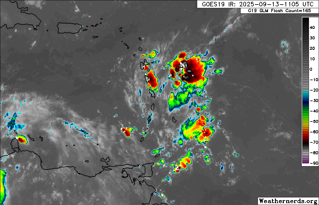
Locally strong thunderstorms are affecting parts of Trinidad, gradually drifting northward due to the passage of a well-defined Tropical Wave (TW32). With light winds, favorable low-level convergence and high moisture and instability, locally intense rainfall is likely.
This pattern of late morning through afternoon activity across the western and northern halves of Trinidad is typical during the Wet Season, where light winds, sea breeze convergence, and daytime heating lead to intense rainfall and impactful street/flash flooding.
Due to the potential for impactful weather, particularly across northern Trinidad, the Trinidad and Tobago Meteorological Service has issued a late-notice and retroactive Adverse Weather Alert for Trinidad and Tobago.
What you need to know
— Rainfall: Through this evening, isolated moderate to heavy showers and thunderstorms are likely, interrupting mostly hot and sunny skies. While little overall rainfall is forecast across both islands, including Tobago, the most intense activity is forecast across the western and northern halves of Trinidad. Across the western and northern half of Trinidad, rainfall totals between 15 and 35 millimeters are forecast, with isolated higher totals possible. Elsewhere, rainfall totals less than 10 millimeters are likely.
— Hazards: Street/flash flooding is likely, mainly across western Trinidad. Gusty winds in excess of 45 KM/H accompanying heavy showers or thunderstorms are possible. Lightning will accompany thunderstorms. Landslides are possible in elevated areas of northwestern Trinidad. Seas are forecast to become agitated in the Gulf of Paria with intense activity.
Latest Alerts

Adverse Weather Alert Discontinued For Western Trinidad
Trinidad and Tobago is NOT under any tropical storm or hurricane threat, watch, or warning at this time.
The Adverse Weather Alert
The Trinidad and Tobago Meteorological Service issued an Adverse Weather Alert (Yellow Level) on Saturday at 12:06 PM. The late-notice alert retroactively went into effect for all of Trinidad and Tobago at 12:01 PM.
It remains in effect through 7:00 PM Saturday. Severe impacts are possible, but the certainty is low, 2/4 on the TTMS likelihood scale, which means the alert could be upgraded to Orange Level.
Trinidad and Tobago is not under any tropical storm watch or warning at this time.
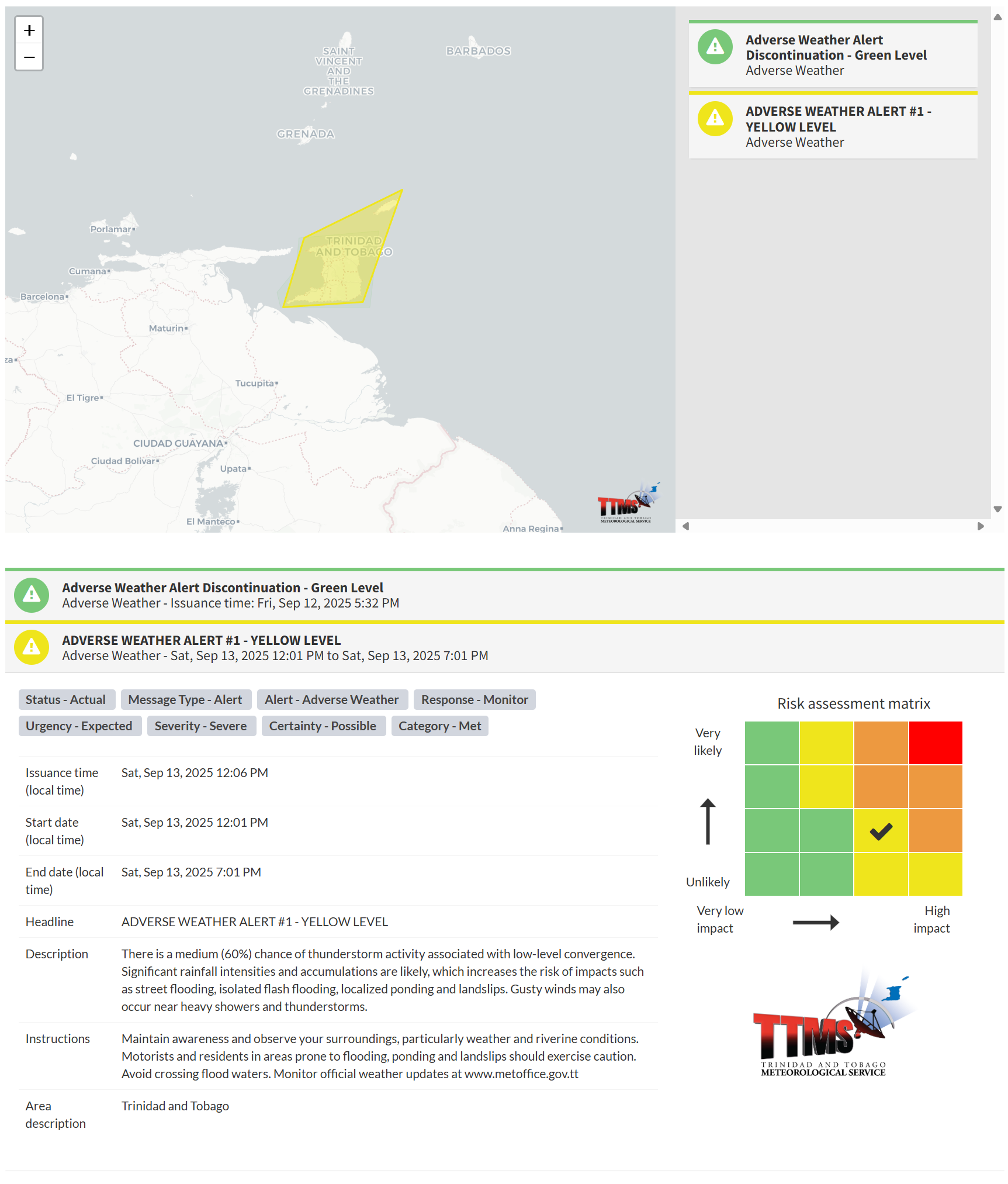
“There is a medium (60%) chance of thunderstorm activity associated with low-level convergence. Significant rainfall intensities and accumulations are likely, which increases the risk of impacts such as street flooding, isolated flash flooding, localized ponding and landslips. Gusty winds may also occur near heavy showers and thunderstorms,” according to the Trinidad and Tobago Meteorological Service. This “alert” status takes into account the possibility of the event occurring. This adverse weather event is possible, with a certainty of two out of four.

The color of the alert indicates the severity of the event and the probability of the event occurring. Currently, the alert level is Yellow. This means that the hazards are possible, but the severity of the impacts is severe for this particular alert. You should be aware of the hazards in your area, including gusty winds exceeding 45 KM/H, street and flash flooding, and frequent lightning.
For a severe Adverse Weather Alert, there is the potential for the loss of a single life or serious injuries where physical defenses are needed, and major losses are possible in confined areas. Income earning may be possible in these severely affected areas for several days, and with several communities affected, external help may be needed for recovery.
The Met Office is advising the public to maintain awareness and observe your surroundings, particularly weather and riverine conditions. Motorists and residents in areas prone to flooding, ponding, and landslips should exercise caution. Avoid crossing flood waters.


