


What’s happening: A cluster of showers and developing thunderstorms has developed east of Trinidad and Tobago and is approaching the country. By early Saturday morning, these showers and thunderstorms are forecast to affect Trinidad primarily, and to a lesser extent, Tobago, with periods of locally heavy rainfall, gusty winds, and frequent lightning as they gradually weaken. An Adverse Weather Alert (Yellow Level) is in effect from 5:00 AM to 5:00 PM today from the Trinidad and Tobago Meteorological Service.
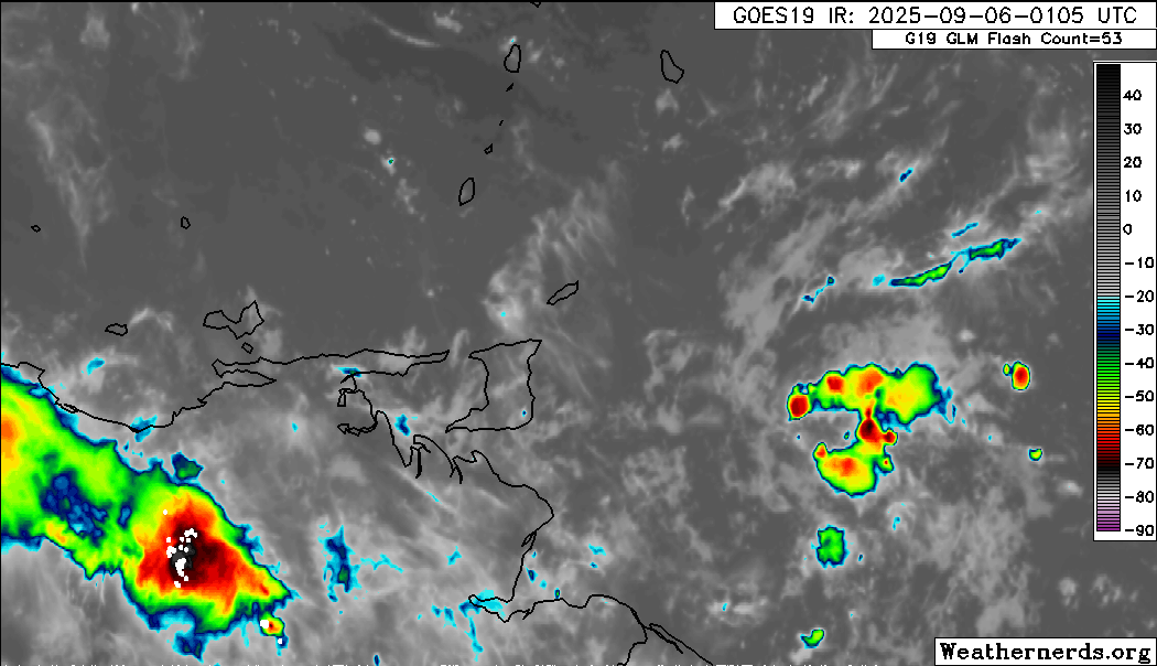
What is it: Over the last six hours, we’ve been tracking a developing cluster of showers and thunderstorms, likely associated with a surface to low-level trough embedded within the Intertropical Convergence Zone, moving westward. This type of activity is typical for the Wet Season.
What to expect: Increasing cloudiness with scattered showers and thunderstorms from 3:00 AM, becoming more frequent through dawn across both islands. Heavier rainfall is forecast to favor the southern and eastern areas of both islands. Activity is forecast to spread westward and northward through the late morning and midday, gradually diminishing across most of Trinidad by the early afternoon, with persisting rain, isolated to scattered showers, and isolated thunderstorms across southern and eastern Trinidad, as well as Tobago, through the late afternoon. Conditions are forecast to settle by nightfall, with a few lingering showers favoring eastern Trinidad and across Tobago as a high-pressure ridge regains dominance.
Hazards: Street/flash flooding, gusty winds exceeding 45 km/h, and frequent lightning are all possible associated with heavy showers and thunderstorms. Particularly across southern and eastern areas, rainfall totals may exceed 25 millimeters, leading to short-lived flooding, favoring Trinidad. Landslides and fallen trees are possible in elevated and forested areas.
What should you do: Remain indoors during thunderstorm activity. Be aware of your surroundings, particularly those who live in flood-prone areas, as street/flash flooding is likely during downpours. At this time, riverine flooding is unlikely. Mariners should exercise extreme caution, as locally rough/choppy seas are likely in heavy showers/thunderstorms. If traversing mountainous and forested areas, be aware of fallen trees and landslides, particularly overnight tonight, as a result of gusty winds.
Latest Alerts

Adverse Weather Alert Discontinued For Western Trinidad
Trinidad and Tobago is NOT under any tropical storm or hurricane threat, watch, or warning at this time.


