


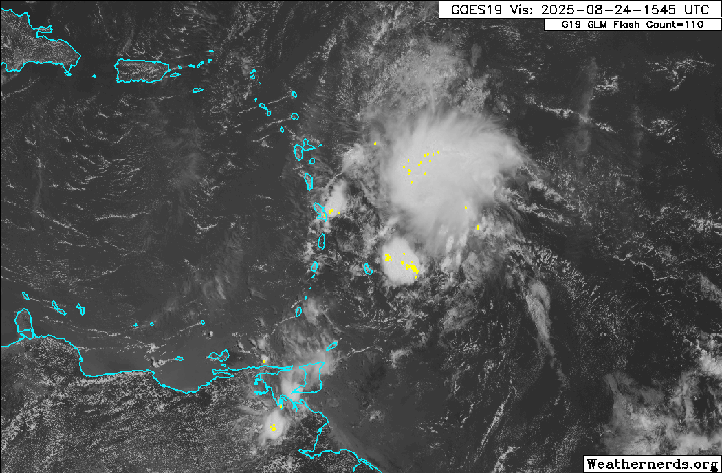
Isolated heavy showers and thunderstorms are affecting parts of Trinidad and Tobago, with additional, but weakening, activity forecast through the evening as Invest 99L, a tropical disturbance, moves well north of the country.
Invest 99L, a well-defined tropical wave that is being monitored by the National Hurricane Center for development, is forecast to move across the Lesser Antilles overnight through Monday.
As forecast, with high moisture, light winds, slow-moving showers and thunderstorms materialized across mainly western and southwestern Trinidad.
All forecast models continue to indicate isolated activity affecting mainly the western areas of both islands on Sunday, with additional scattered activity beyond the alert period early Monday morning and again during the early afternoon, favoring northern and central Trinidad, as well as Tobago.

Currently, Invest 99L has been assigned low chances for tropical cyclone development over the next 48 hours and seven days, respectively, with heavy showers and gusty winds likely to affect the north of Barbados to Antigua.
What you need to know
— Rainfall: On Sunday, most areas will see little rainfall, with southwestern Trinidad, localized areas of western and northern Trinidad, as well as western areas of Tobago receiving between 15 and 25 millimeters in localized heavy showers and thunderstorms. Elsewhere, less than 10 millimeters is forecast in isolated areas. However, beyond the alert period and through Monday, an additional 25 millimeters of rainfall is forecast mainly across the northern half of Trinidad and across Tobago, with isolated higher amounts. In highly localized areas, rainfall amounts of 25 to 50 millimeters are possible over the 48 hours, favoring western and northern Trinidad.
— Hazards: Localized heavy showers or thunderstorms are likely to lead to street or flash flooding, with gusty winds possible up to 45 km/h. Particularly in eastern and northwestern areas, landslides are possible in elevated areas due to relatively saturated soils. With light (and veering) winds through the atmosphere on Sunday afternoon and Monday (beyond the alert), funnel clouds are possible. In isolated strong thunderstorms, frequent lightning is likely, favoring western Trinidad into the Gulf of Paria.
Latest Alerts

TTMS Issues Adverse Weather Alert For T&T
Trinidad and Tobago is NOT under any tropical storm or hurricane threat, watch, or warning at this time.
The Adverse Weather Alert
The Trinidad and Tobago Meteorological Service has updated an Adverse Weather Alert (Yellow Level) on Sunday, August 24th, 2025, for Trinidad, Tobago, and surrounding waters at 4:48 PM. The late-notice alert went into effect from 9:20 AM Sunday (today) and has been extended through 9:00 PM. Impactful weather is likely to occur beyond this alert period due to additional moisture and instability flowing across T&T associated with the ITCZ and a trailing low-level convergence on Monday morning through early afternoon.
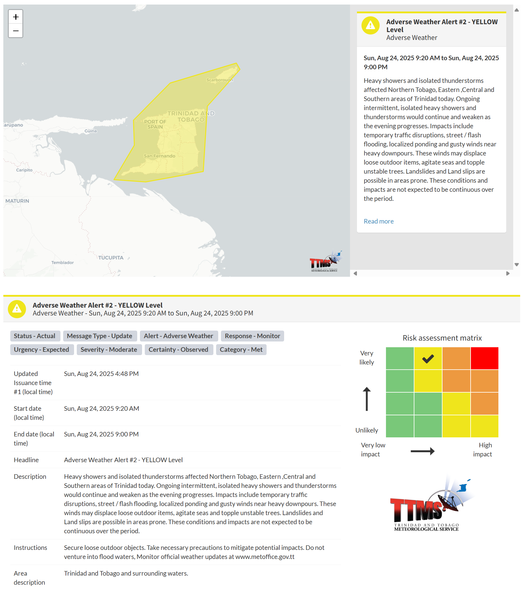
According to the TTMS, this “alert” status considers the possibility of the event occurring. This adverse weather event has been observed, and the following are very likely, according to the TTMS:
- Heavy showers and isolated thunderstorms affected Northern Tobago, Eastern, Central, and Southern areas of Trinidad today.
- Ongoing intermittent, isolated heavy showers and thunderstorms would continue and weaken as the evening progresses.
- Impacts include temporary traffic disruptions, street/flash flooding, localized ponding, and gusty winds near heavy downpours.
- These winds may displace loose outdoor items, agitate sea,s and topple unstable trees. Landslides and Land slips are possible in areas prone.
- These conditions and impacts are not expected to be continuous over the period.

The alert’s color indicates the severity of the event and the probability of its occurrence. Currently, the alert level is Yellow. This means that the hazards have been observed, and the severity of the impacts is moderate for this particular alert. You should be aware of the hazards in your area, which are primarily associated with street or flash flooding, gusty winds exceeding 45km/h, possibly falling trees, landslides, and agitated seas.
A moderate Adverse Weather Alert can result in possible injuries and behavioral changes, which are necessary to ensure safety. Minor property damage may also occur, temporarily disrupting income-earning activities and affecting several communities.
The Met Office advises securing loose outdoor objects. Take necessary precautions to mitigate potential impacts. Monitor official weather updates. Do not venture into flood waters.


