


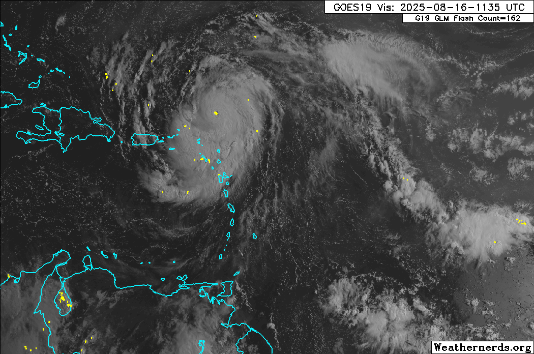
At 11:20 AM Saturday, Hurricane Erin has rapidly strengthened into a powerful Category 5 hurricane.
According to the National Hurricane Center, the system’s center is expected to move just north of the northern Leeward Islands, the Virgin Islands, and Puerto Rico over the weekend.
Based on the forecast path, this system remains well north of T&T, with tropical storm conditions possible and heavy rainfall across the northernmost Leeward Islands through Sunday. This large low-pressure area will also influence winds and atmospheric conditions across the Lesser Antilles through Sunday..
What you need to know
— What has happened: Hurricane Erin has strengthened into a powerful Category 5 hurricane and is forecast to continue moving north of the Leewards and Greater Antilles. Outer rain bands and cloudiness have continued to affect the Leeward Islands and, to a lesser extent, the northern Windwards. In T&T, light to nearly calm winds, with a steering flow from south to north, are allowing for slow-moving showers and thunderstorms to produce potentially impactful flooding across central and northern areas.
— Where is it forecast to move: The National Hurricane Center shows Hurricane Erin is forecast to remain north of the Greater Antilles through the weekend, steering northwest by early next week as it nears the Turks and Caicos.
— The Intensity & Impacts: Tropical storm conditions are possible across the northernmost Leewards, with locally heavy rainfall and agitated seas likely.
— Latest from officials: Tropical Storm Watches are in effect for the northern-most Leeward Islands, including St. Martin, St. Barthelemy, and Sint Maarten. Elsewhere, several islands have alerts and advisories posted for rough seas, flooding, and landslides.
Latest Alert
There are no alerts, watches, or warnings in effect for Trinidad and Tobago from the Trinidad and Tobago Meteorological Service at this time.
Trinidad and Tobago is NOT under any tropical storm or hurricane threat, watch, or warning at this time.
The latest
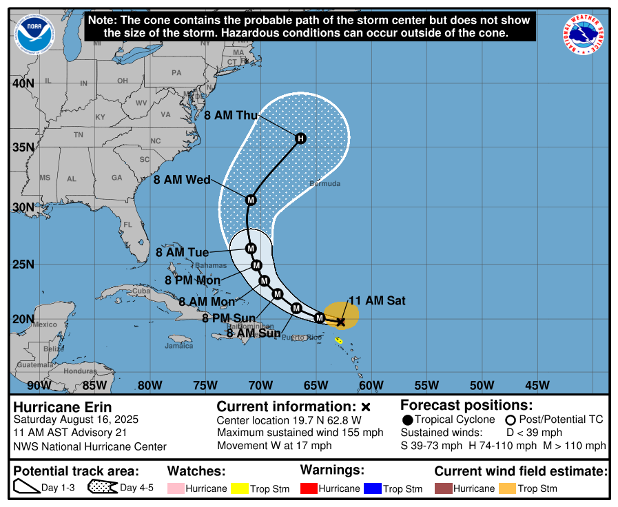
At 11:20 AM, the center of Hurricane Erin was located approximately 170 kilometers north of Anguilla, moving briskly west at 28 km/h. This motion is expected to continue into the weekend, moving just north of the northern Leeward Islands, the Virgin Islands, and Puerto Rico.
Reports from an Air Force Reserve Hurricane Hunter aircraft indicate that Erin has become a Category 5 hurricane on the Saffir-Simpson Hurricane Wind Scale with maximum sustained winds near 160 mph (255 km/h). The minimum pressure has fallen to near 917 mb (27.08 inches).
Hurricane-force winds extend outward up to 45 kilometers from the center, and tropical-storm-force winds extend outward up to 220 kilometers mainly to the north of the center.
Latest Alerts, Watches & Warnings

Tropical Storm Watches
A Tropical Storm Watch is in effect for:
- St. Martin and St. Barthelemy
- Sint Maarten
A Tropical Storm Watch means that tropical storm conditions are possible within the watch area, in this case, within the next 12 hours.
Interests elsewhere in the northern Leeward Islands, Virgin Islands, and Puerto Rico, as well as in the Turks and Caicos and the southeastern Bahamas, should monitor the progress of Erin.
Other Alerts, Watches, and Warnings
Barbados
The Barbados Meteorological Service has the following in effect:
- Excessive Rainfall (Yellow Level): Showers may produce rainfall rates between 15 and 30 mm/hr, leading to street/flash flooding.
- Marine (Yellow Level): Western coastal areas may experience abnormally large waves.
Trinidad and Tobago
Latest Alerts

Adverse Weather Alert Discontinued For Western Trinidad
Trinidad and Tobago is NOT under any tropical storm or hurricane threat, watch, or warning at this time.
Grenada
No alerts, watches, or warnings are in effect from the Grenada Meteorological Service.
St. Vincent and the Grenadines
- Weather Advisory (Yellow Level): Residents and motorists in areas prone to flash flooding and landslides or near rivers and streams should exercise caution.
St. Lucia
No alerts, watches, or warnings are in effect from the Saint Lucia Meteorological Service.
Where is it going?

Over the past several hours, Erin has been moving west compared to its forecast west-northwest track. However, forecast models continue to show that Erin will turn back to the west-northwest with a decrease in forward speed during the 6 to 12 hours on the south side of a subtropical ridge. This motion should then continue through the weekend, taking the core of Erin to the north of the eastern Caribbean Islands through Sunday.
By Monday morning, the western side of the ridge is expected to weaken due to a series of shortwave troughs moving through the mid-latitude westerlies, and that should cause Erin to slow further and make a gradual turn to the north.
As a result, Erin is forecast to move between the U.S. East Coast and Bermuda. Still, with the size of the hurricane, swells are likely to affect much of the southwestern Atlantic, with the NHC also noting that gusts to tropical storm force in Erin’s outer rainbands are likely in portions of the northern Leeward Islands through tonight and over portions of the Virgin Islands and Puerto Rico later today through Sunday. Tropical-storm force wind gusts are possible in the Turks and Caicos Islands and the Southeast Bahamas.
How strong could it get?
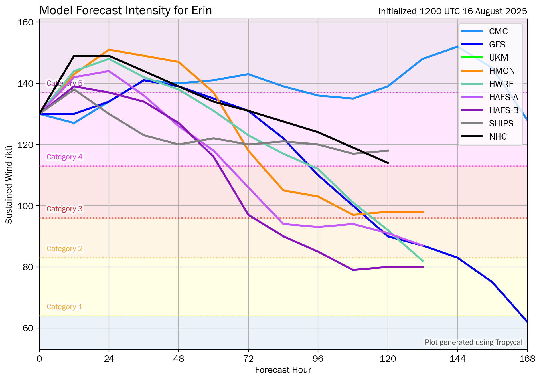
Erin has rapidly strengthened over the last 24 hours, increasing by 70 knots, nearly triple the threshold used to define rapid intensification. Forecast models and the NHC now explicitly maintain Erin as a Category 5 hurricane north of the Leewards and Greater Antilles over the next 24 hours.
However, reports from Air Force Reserve Hurricane Hunter aircraft and land-based radar data from Sint Maarten, report that an outer eyewall is starting to form. The development of the outer eyewall suggests that rapid intensification is expected to end within the next several hours. By tonight, the environment becomes a little less favorable, with increasing northwesterly shear and possible dry air entrainment. This should lead to a gradual weakening of the cyclone through Wednesday, although fluctuations due to eyewall replacement cycles will superimpose on this trend.
What does this mean for the Lesser Antilles?
Outer rainbands are forecast to gradually diminish across the Leewards through today and tonight, still bringing heavy rainfall in showers and thunderstorms.
As Erin moves north, swells are also forecast to propagate across the Atlantic, potentially affecting the Greater and Lesser Antilles by the following week.
Tropical cyclone preparedness plans should be rushed to completion for those in the Leewards, northern coastlines of the Greater Antilles, and should be reviewed by those in the Turks and Caicos, as well as the Southeastern Bahamas. Heavy rainfall is likely to produce floods, landslides, and mudslides, as well as strong winds and gusts that can cause wind damage and rough seas.
Wind
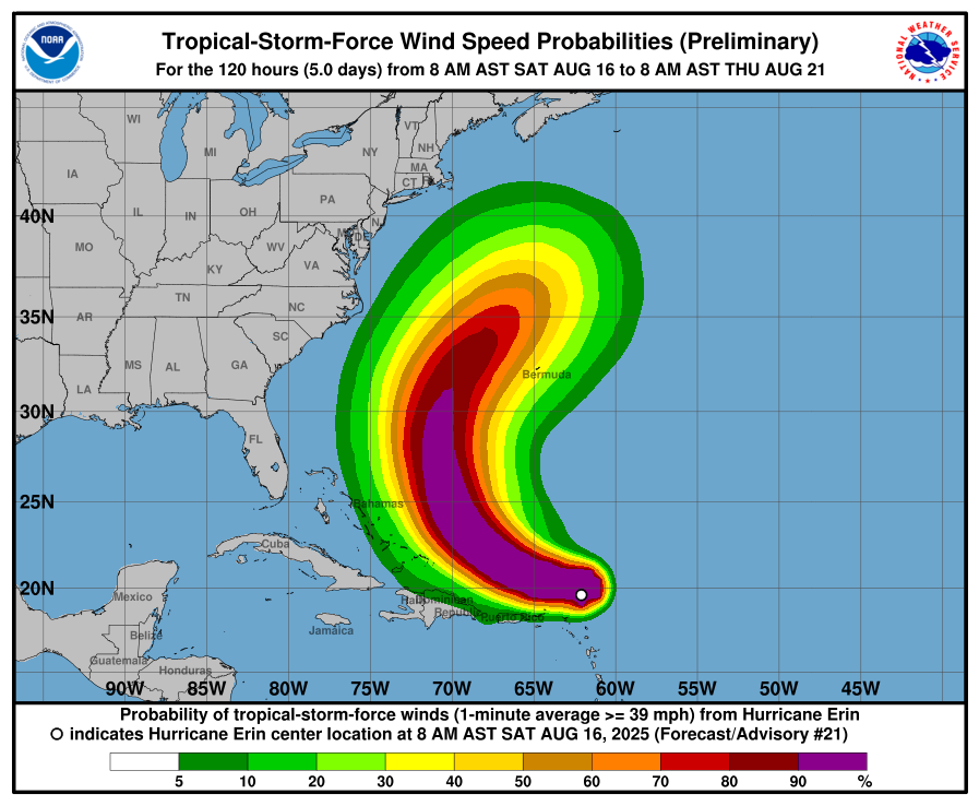
Based on the latest guidance, tropical storm-force wind gusts and sustained winds (above 34 knots, 39 MPH, 63 KM/H) are forecast to remain north of the Leewards and Greater Antilles primarily.
As Hurricane Erin moves north of the Leewards, T&T will continue to experience near-calm conditions to wind from the south/southeast through Sunday. This will lead to a high chance of showers and thunderstorms across central and northern Trinidad during the late morning through afternoon, particularly as activity moves north from Venezuela toward Trinidad and Tobago during the evening and night. Wind gusts can range between 45 KM/H and 55 KM/H through Sunday night, mainly in strong shower or thunderstorm activity.
Rainfall

The highest rainfall accumulations are forecast to occur across the Leewards, as well as portions of the Greater Antilles.
For northeastern South America and T&T, most areas are forecast to receive less than 25 millimeters of rainfall through Sunday. However, in highly isolated areas, particularly southwestern and northern Trinidad, totals between 25 and 50 millimeters are possible due to locally intense showers or thunderstorms.
The outer bands of Erin are expected to continue producing areas of heavy rainfall through Sunday across the northern Leeward Islands, the Virgin Islands, and Puerto Rico. Rainfall totals of 2 to 4 inches (50-100 mm), with isolated totals of 6 inches (150 mm), are expected. Locally considerable flash and urban flooding, along with landslides or mudslides, are possible.
Northern Windward Islands may also receive localized totals between 25 and 75 millimeters, including Martinique, Dominica, and Guadeloupe, and higher totals are possible along western coasts. Over the past 24 hours, parts of Guadeloupe and Martinique recorded localized rainfall totals exceeding 75 millimeters.
Seas and Storm Surge
Swells generated by Erin will begin affecting portions of the northern Leeward Islands, the Virgin Islands, and Puerto Rico this weekend. They will likely spread to the western Atlantic next week. These swells are likely to cause life-threatening surf and rip current conditions.
For Barbuda, Anguilla, and the British Virgin Islands, a High Surf Warning is in effect as waves in open waters are forecast to range between 3-4 meters (10-13 feet), occasionally reaching as high as 4.6 meters (15 feet).
For the remainder of the Leeward Islands, moderate long-period swells are expected to reach the area, causing hazardous conditions along mainly northern and eastern-facing coastlines. The threat level to the lives, livelihoods, properties, and infrastructure of those using the affected coastlines is moderate, with the potential for significant impacts. These swells could cause life-threatening surges and rip currents on affected coastlines.
Seas for these islands may reach 2.1 to 3.4 metres (7 to 11 feet), occasionally or locally reaching near 4 metres (13 feet). Surfs (breaking swells) may reach over 1.8 metres (over 6 feet). These conditions are conducive to the formation of dangerous rip currents.
For Trinidad and Tobago
For Trinidad and Tobago, given that this system is forecast to remain well north of the country, feeder band activity is unlikely. However, Erin’s influence on T&T’s atmosphere is forecast to continue through Sunday.
On Saturday and Sunday, low-level wind speeds are forecast to increase marginally, remaining from the south, which will lead to northward-moving showers and thunderstorms that are likely to develop from late morning through the afternoon. Sea breeze convergence and daytime heating act as triggers for shower/thunderstorm development. Locally intense activity is possible across Tobago, central and northern Trinidad.
Late-evening thunderstorms are expected to develop across northern Venezuela and may move toward southern Trinidad overnight. These thunderstorms will bring locally heavy rainfall to south Trinidad, frequent lightning, and agitated conditions in the Gulf of Paria, particularly south and west-facing coastlines.
By Sunday night, as Erin pulls away from the L:eewards, southeasterly winds are forecast to prevail, with conditions gradually improving as a high-pressure ridge rebuilds and a drier, more stable air mass moves over the region.
Pay close attention to official forecasts from your respective authorities in the coming hours and days. The Trinidad and Tobago Meteorological Service provides official forecasts and early warnings for Trinidad and Tobago.


