


At 11:00 AM Friday, Tropical Storm Erin, the fifth tropical cyclone for the 2025 Atlantic Hurricane Season, strengthened into a Category 1 Hurricane.
According to the National Hurricane Center, the system’s center is forecast to move near or just north of the Leeward Islands on Saturday.
Based on the forecast path, this system is expected to remain well north of T&T, with tropical storm conditions possible and heavy rainfall to the Leeward Islands from tonight into early Saturday. This relatively large low-pressure area will influence winds and atmospheric conditions across the Lesser Antilles through Sunday..
What you need to know
— What has happened: Tropical Storm Erin has strengthened into a hurricane and is forecast to move near/north of the Leewards starting tonight (Friday night). Outer bands and cloudiness have already begun to spread across the Leeward Islands. In T&T, light to nearly calm winds, with a steering flow from south to north, are allowing for slow-moving showers and thunderstorms to produce potentially impactful flooding across northern areas.
— Where is it forecast to move: The National Hurricane Center shows Hurricane Erin is forecast to remain north of the Greater Antilles through the weekend, steering northwest by early next week as it nears the Turks and Caicos.
— The Intensity & Impacts: Tropical storm conditions are possible across the northernmost Leewards, with locally heavy rainfall and agitated seas likely.
— Latest from officials: Tropical Storm Watches are in effect for the northern-most Leeward Islands, including Antigua and Barbuda, St. Martin and St. Barthelemy, Saba and St. Eustatius, and Sint Maarten. Elsewhere, several islands have watches and warnings posted for rough seas, flooding, and landslides.
Latest Alert
There are no alerts, watches, or warnings in effect for Trinidad and Tobago from the Trinidad and Tobago Meteorological Service at this time.
Trinidad and Tobago is NOT under any tropical storm or hurricane threat, watch, or warning at this time.
The latest
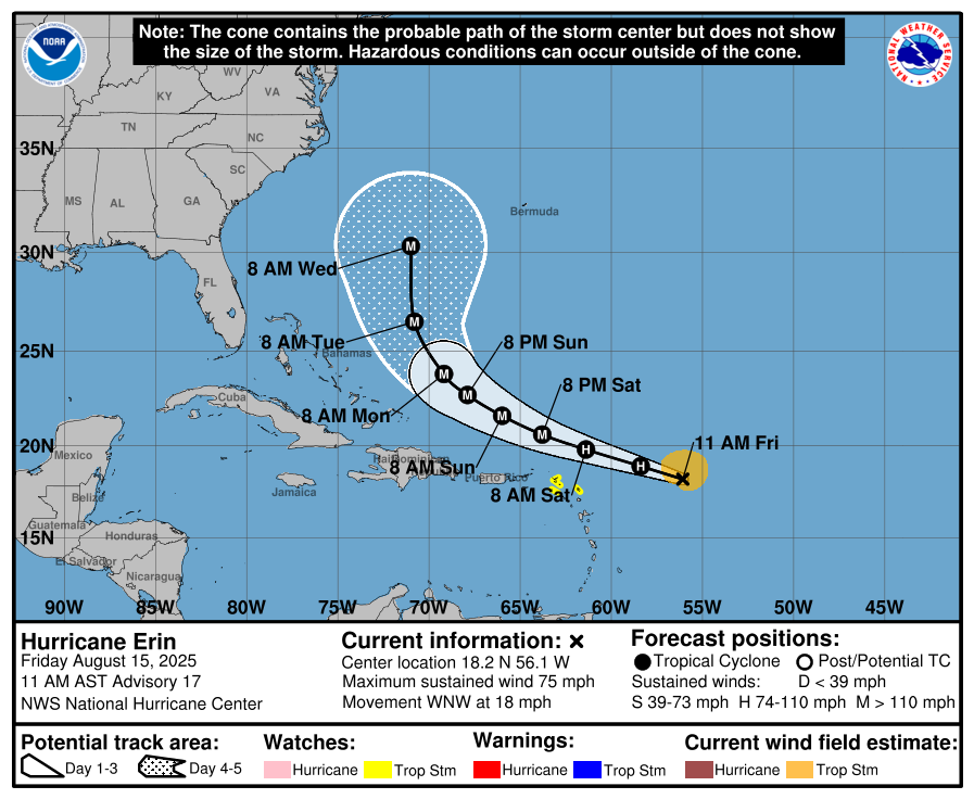
At 11:00 AM, the center of Hurricane Erin was located approximately 740 kilometers east of the northern Leeward Islands, moving briskly west-northwest at 30 km/h. This motion is expected to continue into the weekend, move near or north of the northern Leeward Islands.
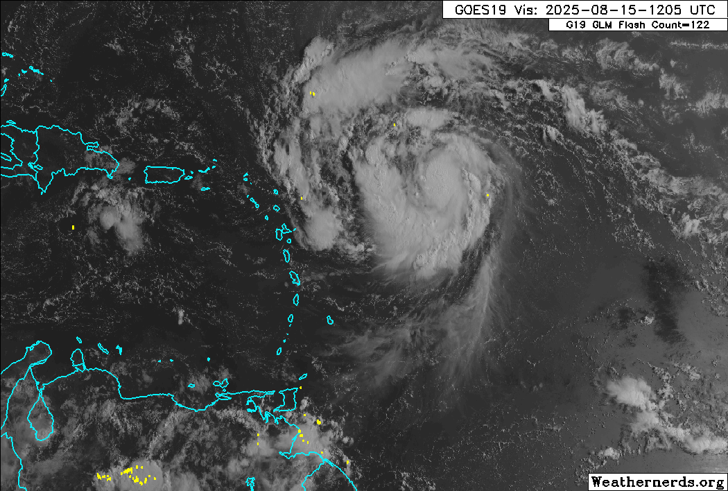
Reports from NOAA and Air Force Reserve Hurricane Hunter aircraft indicate that maximum sustained winds have increased to near 75 mph (120 km/h) with higher gusts. Steady to rapid strengthening is expected during the next two to three days, and Erin is forecast to become a major hurricane during the weekend.
Hurricane-force winds extend outward up to 35 kilometers from the center, and tropical-storm-force winds extend outward up to 185 kilometers mainly to the north of the center.
Latest Alerts, Watches & Warnings

Tropical Storm Watches
A Tropical Storm Watch is in effect for:
- Anguilla and Barbuda
- St. Martin and St. Barthelemy
- Saba and St. Eustatius
- Sint Maarten
A Tropical Storm Watch means that tropical storm conditions are possible within the watch area, generally within 48 hours.
Interests elsewhere in the northern Leeward Islands, Virgin Islands, and Puerto Rico should monitor the progress of Erin.
Other Alerts, Watches, and Warnings
Barbados
The Barbados Meteorological Service has the following in effect:
- Excessive Rainfall (Yellow Level): Showers may produce rainfall rates between 25 and 75 mm/hr, leading to street/flash flooding.
- Marine (Yellow Level): Western coastal areas may experience abnormally large waves.
Trinidad and Tobago
Latest Alerts

Adverse Weather Alert Discontinued For Western Trinidad
Trinidad and Tobago is NOT under any tropical storm or hurricane threat, watch, or warning at this time.
Grenada
No alerts, watches, or warnings are in effect from the Grenada Meteorological Service.
St. Vincent and the Grenadines
- Marine Advisory (Yellow Level): Occasionally southerly wind gusts and swells for Saturday.
St. Lucia
No alerts, watches, or warnings are in effect from the Saint Lucia Meteorological Service. However, Residents and motorists in areas prone to flooding and landslides are advised to exercise caution.
Where is it going?
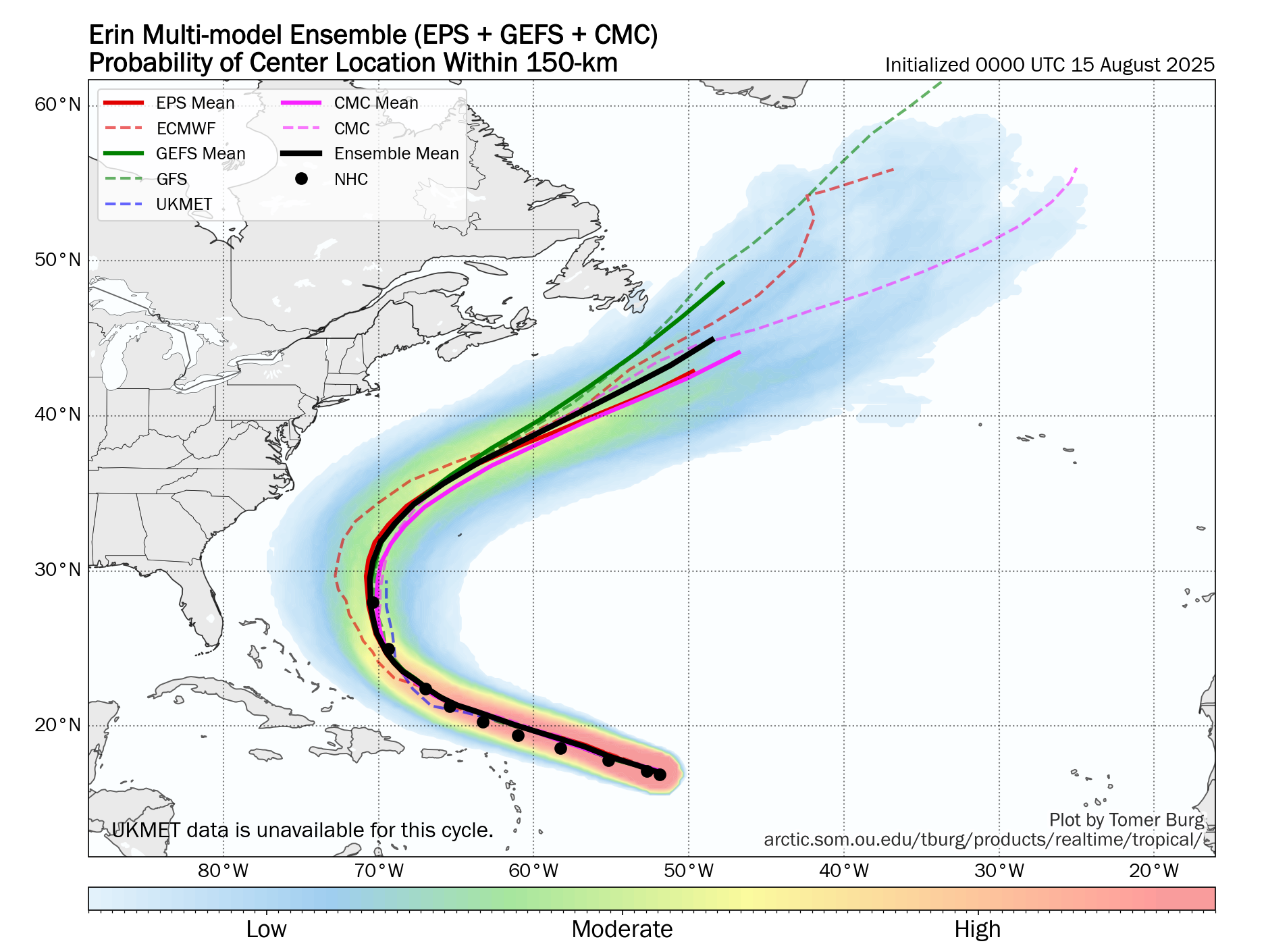
Forecast models show Hurricane Erin being steered west-northwest by a strong low- to mid-level ridge, which is expected to continue through Sunday. Encroaching mid-latitude westerly flow is forecast to cause a weakness to develop in the ridge during the latter part of the forecast period, and this will result in the hurricane gradually turning northwestward and northward.
The National Hurricane Center still maintains that there is still uncertainty about what impacts Erin may bring to portions of the Bahamas, the east coast of the United States, and Bermuda in the long range.
How strong could it get?
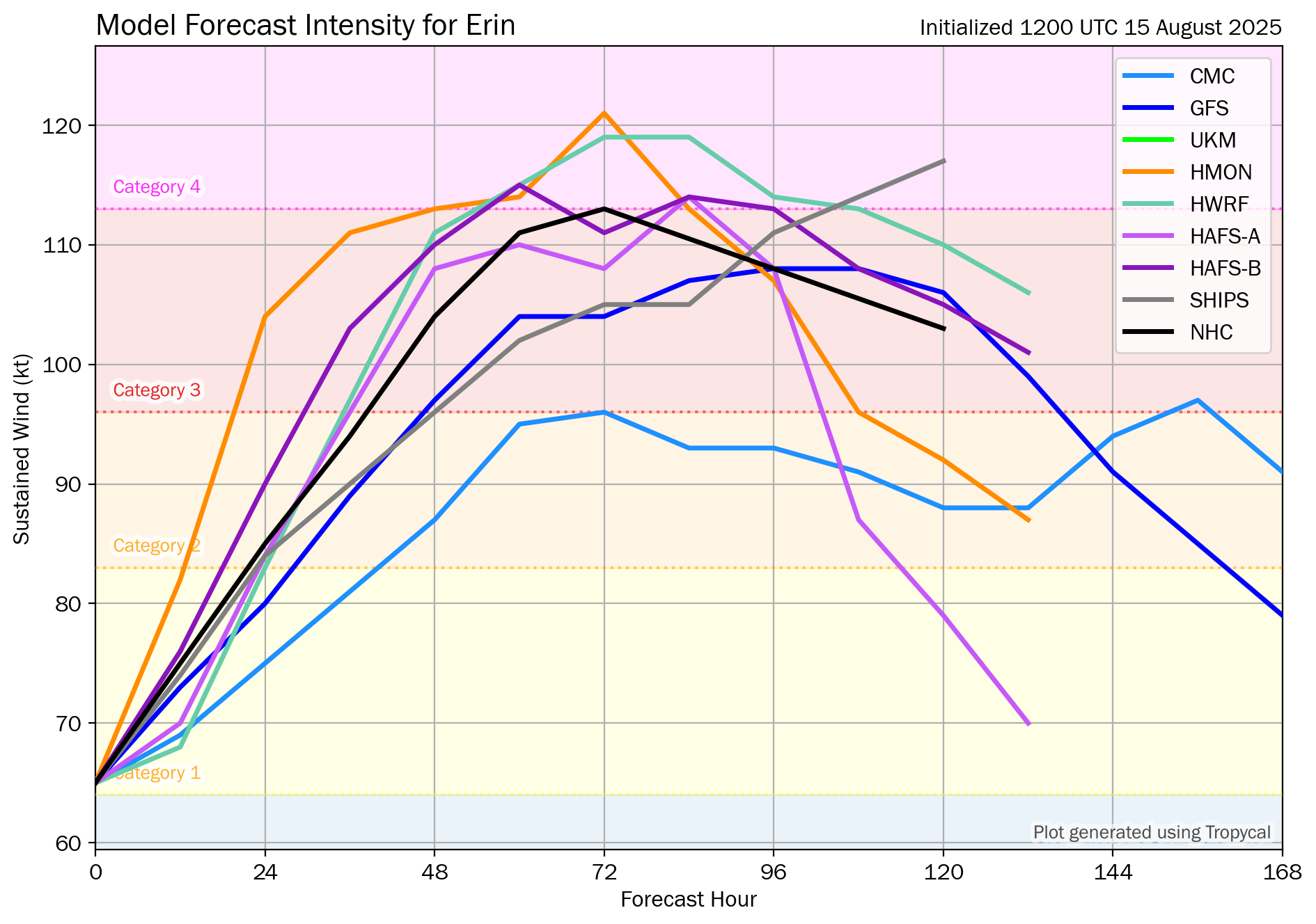
Erin is currently in a favorable environment for strengthening, although there are some uncertainties about whether dry air is entraining into the core. The improved low-level structure indicates potential for rapid strengthening, with Erin likely becoming a major hurricane on Saturday and potentially reaching Category 4 strength by Sunday.
What does this mean for the Lesser Antilles?
Erin is forecast to bring heavy rainfall, potentially tropical-storm-force winds, and waves to the Leewards and northern coastlines of the Greater Antilles. As Erin moves north, swells are also forecast to propagate across the Atlantic, potentially affecting the Greater and Lesser Antilles by late next week.
Tropical cyclone preparedness plans should be rushed to completion for those in the Leewards. Heavy rainfall is likely to produce floods, landslides, and mudslides, as well as strong winds and gusts that can cause wind damage and rough seas.
Wind
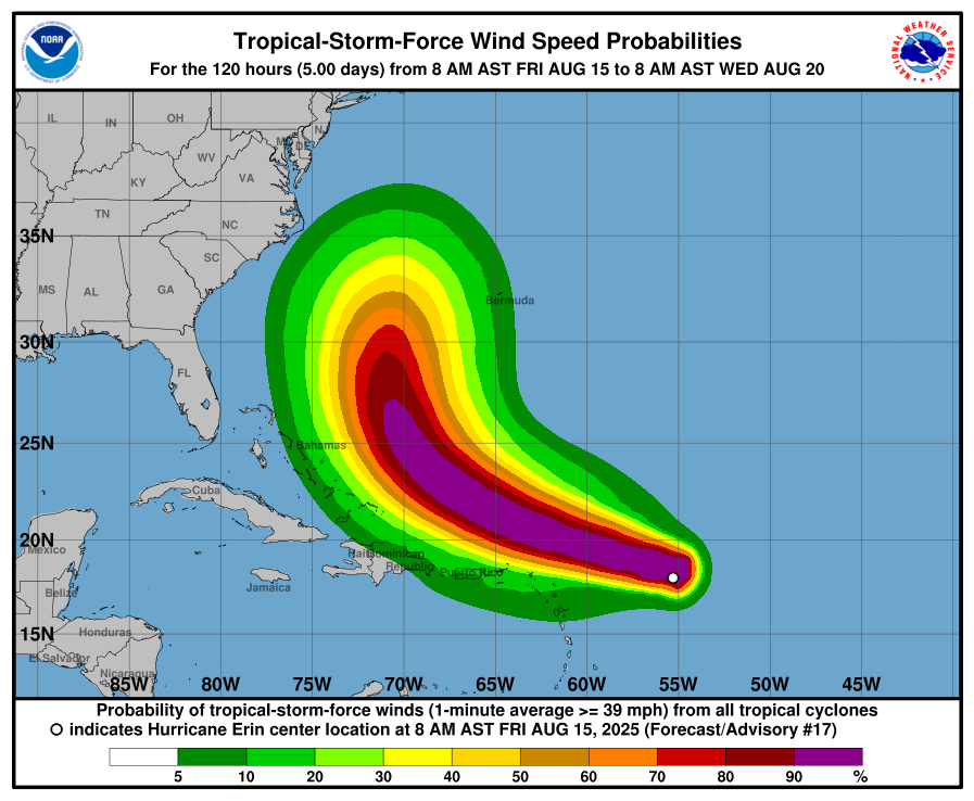
Based on the latest guidance, tropical storm-force wind gusts and sustained winds (above 34 knots, 39 MPH, 63 KM/H) are forecast to primarily remain north of the Leewards, with northern-most Leeward Islands having a 5-20% chance of tropical-storm-force winds.
As Hurricane Erin moves north of the Leewards, T&T will experience near-calm to westerly winds tonight, then near-calm to wind from the south/southeast through Sunday. This will lead to a high chance of showers and thunderstorms, particularly as activity moves north from Venezuela toward Trinidad and Tobago during the evening and night. Wind gusts can range between 45 KM/H and 55 KM/H through Sunday night, mainly in strong shower or thunderstorm activity.
Rainfall

The highest rainfall accumulations are forecast to occur across the Leewards, as well as portions of the Greater Antilles.
For northeastern South America and T&T, most areas are forecast to receive less than 25 millimeters of rainfall through Sunday. However, in highly isolated areas, particularly southwestern and northern Trinidad, totals between 25 and 50 millimeters are possible due to locally intense showers or thunderstorms.
The outer bands of Erin are expected to produce areas of heavy rainfall tonight into Sunday across the northern Leeward Islands, the Virgin Islands, and Puerto Rico. Rainfall totals of 2
to 4 inches (50-100 mm), with isolated totals of 6 inches (150 mm), are expected. This rainfall may lead to isolated and locally considerable flash and urban flooding, as well as landslides or mudslides.
Northern Windward Islands may also receive localized totals between 25 and 75 millimeters, including Martinique, Dominica, and Guadeloupe, and higher totals are possible along western coasts.
Seas and Storm Surge
Swells generated by Erin will begin affecting portions of the northern Leeward Islands, the Virgin Islands and Puerto Rico by this weekend. They will likely spread to the western Atlantic next week. These swells are likely to cause life-threatening surf and rip current conditions. Please consult products from your local weather forecast office.
For islands under a Tropical Storm Watch, moderate long-period swells are expected to reach the area, causing hazardous conditions along mainly northern and eastern facing coastlines. The threat level to the lives, livelihoods, properties, and infrastructure of those using the affected coastlines is moderate, with the potential for significant impacts. These swells could cause life-threatening surges and rip currents on affected coastlines.
Seas for these islands, including St. Kitts and Nevis, which is not under a Tropical Storm Watch, may reach 1.8 to 3.1 metres (6 to 10 feet), occasionally or locally reaching near 3.7 metres (12 feet). Surfs (breaking swells) may reach over 1.8 metres (over 6 feet). These conditions are conducive to the formation of dangerous rip currents.
For Trinidad and Tobago
For Trinidad and Tobago, given that this system is forecast to remain well north of the country, feeder band activity is unlikely. However, Erin’s influence on T&T’s atmosphere is forecast to continue through Sunday.
On Friday into Saturday, low-level winds are forecast to come from the southwest, which may lead to late-evening thunderstorms that develop across northern Venezuela and move toward southern Trinidad overnight. These thunderstorms will bring locally heavy rainfall to southern Trinidad, frequent lightning, and agitated conditions in the Gulf of Paria, particularly south and west-facing coastlines.
On Saturday and Sunday, low-level wind speeds are forecast to increase marginally, remaining from the south, which will lead to northward-moving showers and thunderstorms that are likely to develop from late morning through the afternoon. Sea breeze convergence and daytime heating act as triggers for shower/thunderstorm development. Locally intense activity is possible across Tobago, northern and western Trinidad.
On Friday through Sunday, with southerly winds, strong evening thunderstorms may also move off the Venezuelan coastline south of Trinidad and move toward the country in the Gulf of Paria, creating hazardous marine conditions and producing frequent, dangerous lightning.
By Sunday night, as Erin pulls away from the L:eewards, southeasterly winds are forecast to prevail, with conditions gradually improving as a high-pressure ridge rebuilds and a drier, more stable air mass moves over the region.
Pay close attention to official forecasts from your respective authorities in the coming hours and days. The Trinidad and Tobago Meteorological Service provides official forecasts and early warnings for Trinidad and Tobago.


