Over the next three days, T&T is expected to experience fairly wet weather due to a combination of abundant moisture moving in from the south, favorable low-level convergence, and a surface trough interacting with the Intertropical Convergence Zone.
Key Messages:
— Those living in low-lying and flood-prone areas should pay close attention to forecasts, early warning messages from the TTMS, and watercourses in their area. Ensure you have a plan in place to protect lives, livelihoods, and property in the event of flooding.
— Heavy rainfall is likely on Thursday and Saturday across parts of T&T, which is likely to lead to localized street/flash flooding.
— Short-lived, localized heavy rainfall is possible on Friday, favoring southern and western Trinidad, which may lead to brief and sporadic street/flash flooding.
— The tropical threats in the Atlantic Basin being monitored by the National Hurricane Center, including Tropical Wave 23 (Invest 96L) and Tropical Storm Dexter, pose NO threat to T&T and the Lesser Antilles at this time.
What you need to know
— Rainfall: Over the next three days, through Saturday night, overall rainfall accumulations across Trinidad are forecast to range between 50 and 100 millimeters, with isolated higher totals, favoring southern, central, and eastern Trinidad, and where slow-moving or persisting thunderstorms and heavy showers occur. Across Tobago, between 25 and 50 millimeters of rainfall is forecast, with isolated higher totals possible along windward and eastern coastlines.
— Saharan Dust: Little to no Saharan Dust is forecast to move across T&T through the weekend.
— Hazards: Through Saturday night, heavy showers or thunderstorms are likely to lead to street or flash flooding, with gusty winds possible. With repeated periods of rain, showers, and thunderstorms likely, landslides are possible in elevated areas. With light (and veering) winds through the atmosphere over the weekend, funnel clouds are possible, favoring western and southern areas of Trinidad and Tobago. In isolated strong thunderstorms, frequent lightning is likely, favoring western Trinidad.
— Marine: Moderate seas are forecast in Trinidad and Tobago’s open waters through Friday, with slight to moderate conditions through the weekend. Waves in open waters are forecast to range between 1.5m and 2.0m through Friday, and 1.0m through 1.25m over the weekend. All marine interests are advised to exercise caution in the vicinity of heavy showers and thunderstorms. Spring Tides end on Tuesday, August 12th.
Latest Alerts
TTMS Issues Adverse Weather Alert For T&T
Trinidad and Tobago is NOT under any tropical storm or hurricane threat, watch, or warning at this time.
The Forecast
Thursday
ThursdayFriday
FridaySaturday
SaturdayMarine Forecast
Slight to Moderate Seas Forecast For T&T
Temperatures
Thursday
Low: 24-25°C
High: 28-30°C
Feels Like: 30-35°C
Friday
Low: 24-25°C
High: 30-31°C
Feels Like: 30-35°C
Saturday
Low: 24-25°C
High: 28-30°C
Feels Like: 30-35°C
Forecast Impacts
Flooding
Over the next three days, through Saturday night, overall rainfall accumulations across Trinidad are forecast to range between 50 and 100 millimeters, with isolated higher totals, favoring southern, central, and eastern Trinidad, and where slow-moving or persisting thunderstorms and heavy showers occur. Across Tobago, between 25 and 50 millimeters of rainfall is forecast, with isolated higher totals possible along windward and eastern coastlines.
Street & Flash Flooding
Street & Flash FloodingRiverine Flooding
Riverine FloodingForecast Rainfall Totals
- Thursday: Most areas across Trinidad are forecast to record rainfall totals ranging from 15 to 25 millimeters, with isolated totals near 75 millimeters possible. These higher totals are likely to favor the eastern half of Trinidad, and possible in localized areas of northwestern and southern Trinidad. Across Tobago, between 5 and 15 millimeters of rainfall is forecast, with locally higher totals expected to favor the south and eastern coastlines.
- Friday: Across both islands, between 5 and 15 millimeters of rain are likely, with higher totals of up to 25 millimeters favoring the southern and eastern halves of Trinidad, as well as along the western coastal areas.
- Saturday: Across both islands, between 10 and 20 millimeters of rainfall is forecast, with totals up to 25 millimeters, favoring eastern coastal areas. It should be noted that more extreme, but less likely scenarios show widespread totals between 25 and 50 millimeters across both islands. While this outcome is less likely, it is still important to note, given the favorable atmospheric conditions.

Understanding Rainfall Accumulations
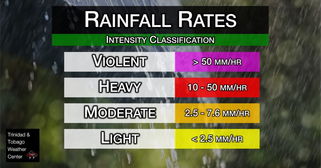
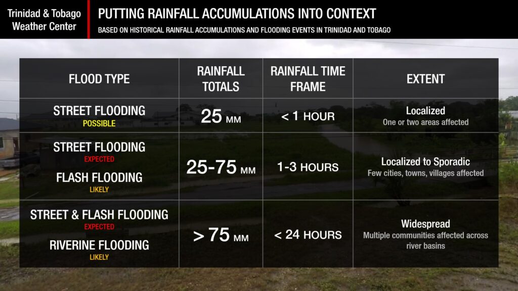
Putting the rainfall forecast into context, rainfall rates in excess of 50 millimeters per hour or areas that receive in excess of 25 millimeters within an hour tend to trigger street flooding across the country or flash flooding in northern Trinidad. For riverine flooding to occur, a large area of the country (not just in highly localized areas of western coastal Trinidad) would have to record upwards of 75 millimeters within 24 hours, and rainfall would have to fall across major rivers’ catchment areas.

Strong Thunderstorms
Strong ThunderstormsWhat is a strong or severe thunderstorm?
Given how rare these types of thunderstorms are in our region – we classify a severe or strong thunderstorm as one that produces any of the following:
- Damaging wind gusts exceeding 63 KM/H;
- Frequent lightning (more than 30 cloud-to-ground strikes within a 10-minute period);
- Hail (of any size);
- Rainfall of more than 50 millimeters or more within an hour or exceeding 75 millimeters or more within three hours;
- The sighting of a funnel cloud or touchdown of a waterspout/tornado associated with the thunderstorm.
Gusty Winds
Gusty WindsWith wind gusts exceeding 55 km/h, whole trees can be in motion, with larger trees and weaker branches falling. Light outdoor objects can topple or become airborne, such as garbage cans, loose galvanize, construction material, and outdoor furniture. Tents may also jump.
Other Hazards
Saharan Dust concentrations are forecast to be mild to non-existent through the next five days, with our next surge of dust moving in by Tuesday.
Saharan Dust Forecast
Dust-Free Days Ahead For T&T As Saharan Dust Stays North
Why I May Not/Will Not See Rainfall?
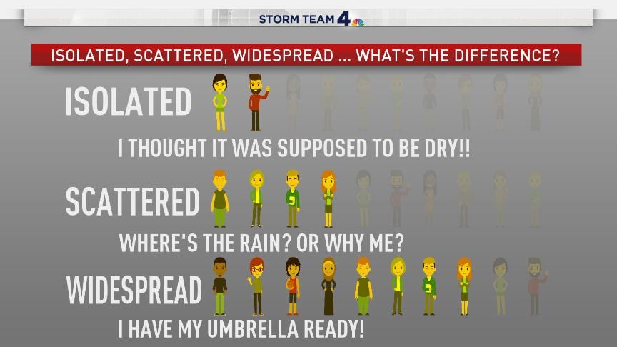
A frequent complaint is that the forecast is wrong because I didn’t experience any rainfall. Scattered showers mean that you, individually, may experience some showers intermittently throughout the day, and there is a higher chance for this activity than for isolated activity. Widespread showers mean that nearly all people and areas can expect rainfall.
Isolated to scattered rainfall is forecast over the next three days.

Forecast Discussion

Tropical Waves (As of 2:00 AM August 7th)
— Tropical Wave 23 (Invest 96L: Located along 35W from 19N southward, moving west at around 5-10 knots (9-18 km/h). This tropical wave is currently producing a large area of disorganized showers and thunderstorms. The National Hurricane Center is monitoring this tropical wave for development, giving it a 60% chance of formation over the next seven days. Environmental conditions are forecast to be generally conducive for gradual development, and a tropical depression could form over the weekend as the system moves west-northwestward to northwestward across the central tropical and subtropical Atlantic, posing no direct threat to T&T and the Lesser Antilles.
On Thursday, a low-level confluent pattern is forecast to persist, bringing anomalously moist air that will fuel scattered showers and isolated thunderstorms across T&T under a generally favorable environment: favorable low-level convergence, upper-level divergence, relatively light wind shear, with enhanced instability between the low and mid-levels of the atmosphere. However, some drier air at the mid-to-upper levels of the atmosphere will limit deep convection (heavier showers and stronger thunderstorms) from persisting. By nightfall, all levels of the atmosphere become progressively drier, limiting the persistence or strength of overnight convection (showers/thunderstorms).
A surface to mid-level trough is forecast to approach (Friday) and move westward across the Windward Islands, including T&T, on Saturday, interacting with the Intertropical Convergence Zone. Ahead of this trough, with a generally drier atmosphere, rainfall will be more isolated with moderate to strong (20-30 knot) wind shear limiting persisting activity. On Saturday, this wind shear notably decreases, with upper-level divergence increasing significantly, which will support deep convection. Additionally, this trough will also lead to a decrease in wind speeds across T&T and the Windwards, potentially resulting in north- and even westward-moving shower/thunderstorm activity on Saturday. This is where the similarities among top global models end.
While both top global models (ECMWF-European and GFS-American) show the atmosphere becoming progressively moist by Friday night into Saturday morning, the GFS model shows a near-saturated atmosphere, with relative humidity exceeding 95%, extreme vertical instability, and veering winds (clockwise through the atmosphere) from the surface to the mid-levels, from 0 to nearly 7.5 kilometers into the atmosphere. This is one of the most extreme outputs from the GFS we’ve seen for T&T outside of a tropical cyclone, and within 48 hours of the forecast event. With extreme runs, we usually lean on model trends of the same model to determine if a particular run is anomalous. For the last six runs of the GFS (since Tuesday morning), the GFS has stuck to its guns of having an extreme rainfall event occurring across T&T between Thursday and Saturday, with this latest run producing 72-hour rainfall totals as high as 325 millimeters of rain across T&T. We still believe this is unrealistic and beware of social media posts and videos showing these extreme model runs.
Using a combination of other leading global models and their ensembles, as well as high-resolution local models, atmospheric conditions are conducive to heavy rainfall on Saturday, but it is likely not as extreme as what the GFS is showing. Rainfall totals are forecast to be high, but not as extreme as those indicated by the GFS. Still, with forecast 72-hour rainfall totals as high as 100 millimeters, the risk of flooding in flood-vulnerable T&T is present, and high for street/flash flooding, while medium for riverine flooding.
Key Messages:
— Those living in low-lying and flood-prone areas should pay close attention to forecasts, early warning messages from the TTMS, and watercourses in their area. Ensure you have a plan in place to protect lives, livelihoods, and property in the event of flooding.
— Heavy rainfall is likely on Thursday and Saturday across parts of T&T, which is likely to lead to localized street/flash flooding.
— Short-lived, localized heavy rainfall is possible on Friday, favoring southern and western Trinidad, which may lead to brief and sporadic street/flash flooding.
While there are no alerts, watches, or warnings in effect for T&T from the Trinidad and Tobago Meteorological Service at this time, this may change so pay close attention to information coming out of the TTMS.


