


The axis of a well-defined tropical wave is forecast to move across T&T from this afternoon through tomorrow, interacting with the Intertropical Convergence Zone, bringing a high chance of heavy showers and thunderstorms. For Trinidad, isolated strong thunderstorms are possible through Wednesday afternoon, prompting the Trinidad and Tobago Meteorological Service to issue an Adverse Weather Alert.
What you need to know
— Rainfall: Most areas will see rainfall ranging from 5 to 10 millimeters, with isolated totals between 10 and 25 millimeters across both islands. The rainfall is expected to favor western coastal, southern, and eastern coastal Trinidad, as well as north and east Tobago. With the possibility of locally strong thunderstorms on Wednesday, even higher 24-hour totals are possible, favoring northwestern Trinidad.
— Hazards: Heavy showers or thunderstorms are likely to lead to street or flash flooding, with gusty winds possible up to 45 km/h. With repeated afternoon showers and thunderstorms likely across northern and western areas, landslides are possible in elevated areas, particularly across northern and northwestern Trinidad. With light (and veering) winds through the atmosphere on Wednesday, funnel clouds are possible, favoring western and southern areas of Trinidad and Tobago. In isolated strong thunderstorms, frequent lightning is likely, favoring northwestern Trinidad.
Latest Alerts

Adverse Weather Alert Discontinued For Western Trinidad
Trinidad and Tobago is NOT under any tropical storm or hurricane threat, watch, or warning at this time.
The Adverse Weather Alert
The Trinidad and Tobago Meteorological Service issued an Adverse Weather Alert (Yellow Level) on Wednesday, July 23rd, 2025, for Trinidad at 9:01 AM. The alert went into effect from 10:00 AM on Wednesday (today) through 6:00 PM. Impactful weather is likely to occur beyond this alert period due to additional moisture and instability flowing across T&T associated with the ITCZ and a trailing low-level trough through Thursday.
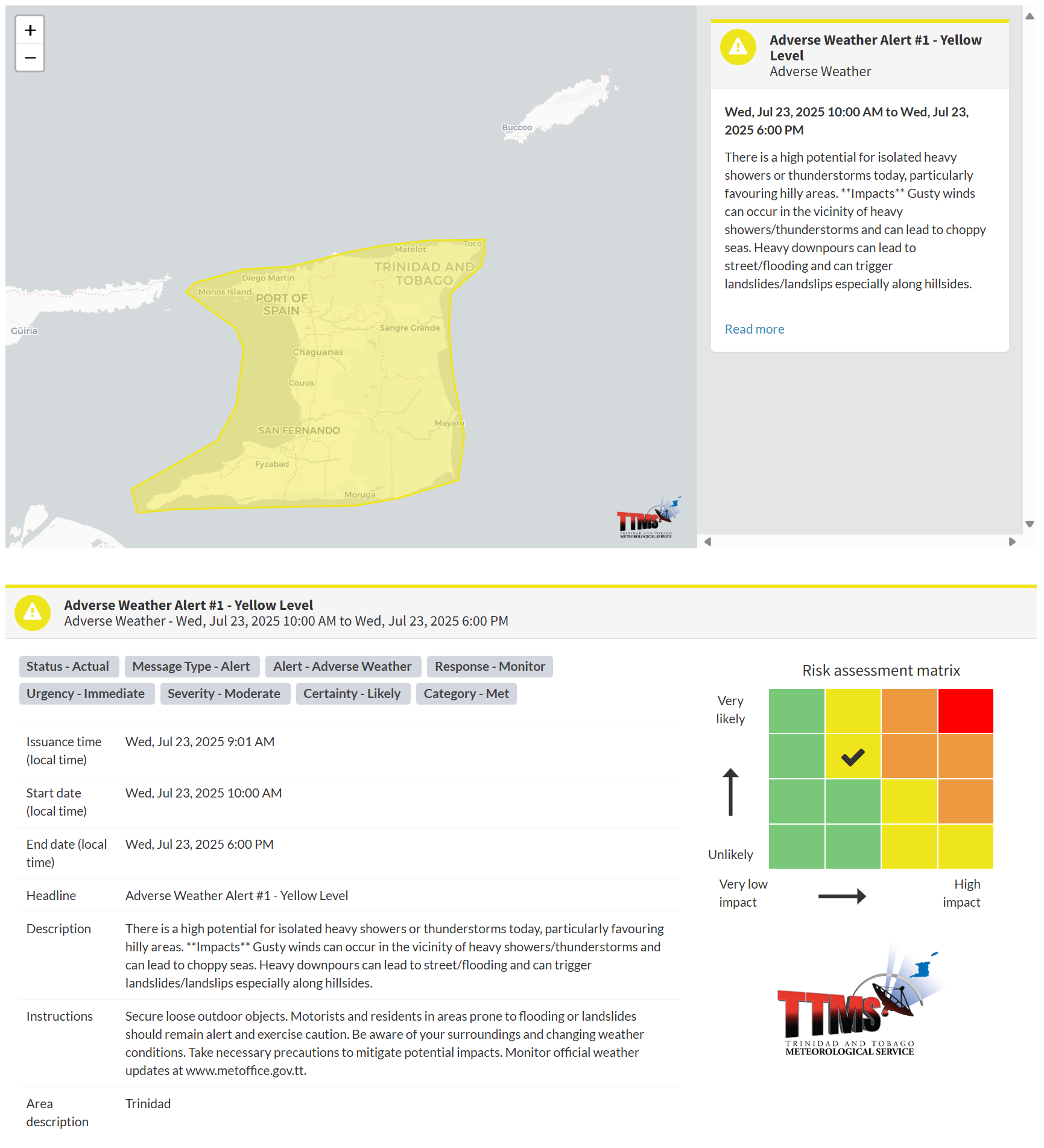
According to the TTMS, this “alert” status considers the possibility of the event occurring. This adverse weather event is likely, and the following are likely, according to the TTMS:
- There is a high potential for isolated heavy showers or thunderstorms today, particularly favouring hilly areas.
- Gusty winds can occur in the vicinity of heavy showers/thunderstorms and can lead to choppy seas.
- Heavy downpours can lead to street flooding and trigger landslides/landslips, especially along hillsides.

The alert’s color indicates the severity of the event and the probability of its occurrence. Currently, the alert level is Yellow. This means that the hazards are likely, and the severity of the impacts is moderate for this particular alert. You should be aware of the hazards in your area, which are primarily associated with street or flash flooding, gusty winds exceeding 45km/h, possibly falling trees, landslides, and agitated seas.
A moderate Adverse Weather Alert can result in possible injuries and behavioral changes, which are necessary to ensure safety. Minor property damage may also occur, temporarily disrupting income-earning activities and affecting several communities.
The Met Office advises securing loose outdoor objects. Motorists and residents in areas prone to flooding or landslides should remain alert and exercise caution. Be aware of your surroundings and changing weather conditions. Take necessary precautions to mitigate potential impacts. Monitor official weather updates.


