


The axis of Tropical Wave 18 is moving across the Lesser Antilles, interacting with the Intertropical Convergence Zone ITCZ), producing showers and thunderstorms mainly north of T&T. In the wake of Tropical Wave 18, more showers and thunderstorms are primarily forecast tomorrow, with Tropical Wave 19 forecast to bring even more rainfall by Friday night through Saturday.
What you need to know
— What has happened: Over the past 12 hours, highly isolated showers and thunderstorms across Trinidad and Tobago have produced locally heavy rainfall, mainly interrupting sunny and hot conditions. However, high rainfall rates led to sporadic reports of street flooding along the East-West Corridor, with gusty winds bringing down trees along the North Coast.
— What to expect: Isolated to scattered showers and thunderstorms are forecast mainly from dawn through tomorrow afternoon across both islands.
— Hazards: While the likelihood of these hazards materializing has decreased this evening through tonight, the hazard profile remains unchanged. The main hazards will be locally heavy rainfall producing street and flash flooding, accompanied by gusty winds near and exceeding 45 km/h. Seas may become locally rough or agitated during heavy showers or thunderstorm activity. Along hilly areas of northern and eastern T&T, landslides are also possible.
Latest Alerts

Adverse Weather Alert Discontinued For Western Trinidad
Trinidad and Tobago is NOT under any tropical storm or hurricane threat, watch, or warning at this time.
The Adverse Weather Alert Discontinuation
The Trinidad and Tobago Meteorological Service discontinued the Adverse Weather Alert (Yellow Level) on Wednesday at 5:05 PM
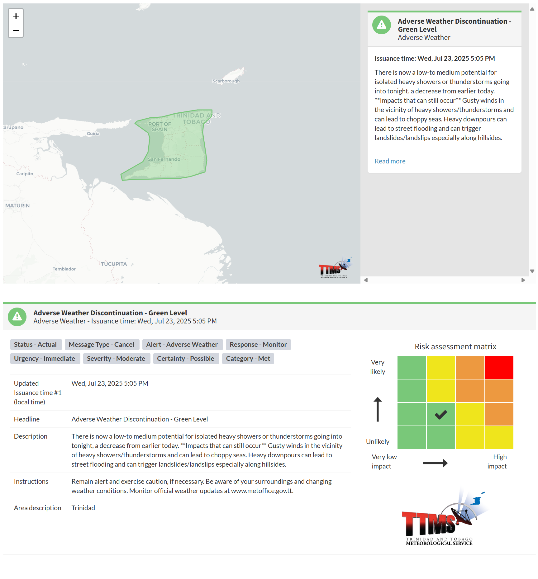
The TTMS states, “There is now a low-to medium potential for isolated heavy showers or thunderstorms going into tonight, a decrease from earlier today.”
This “alert” status considers the possibility of the event ending, with certainty at its second-lowest level, at “possible”. Discontinuations and green-level alerts have historically been issued with a likelihood of ‘very likely/observed’ or ‘likely’.
This is because the following impacts can still occur, according to the TTMS: “Gusty winds in the vicinity of heavy showers/thunderstorms can lead to choppy seas. Heavy downpours can lead to street flooding and can trigger landslides/landslips, especially along hillsides.”

The alert’s color indicates the severity of the event and the probability of its occurrence. Currently, the alert level is green. This means that the hazards are still possible, and the severity of the impacts is moderate for this particular alert. You should remain aware of the hazards in your area, which are primarily associated with street or flash flooding, gusty winds exceeding 45 km/h, possibly falling trees, landslides, and agitated seas.
A moderate Adverse Weather Alert can result in possible injuries and behavioral changes, which are necessary to ensure safety. Minor property damage may also occur, temporarily disrupting income-earning activities and affecting several communities.
The Met Office advises the population to monitor official news sources and weather updates, remain alert, and exercise caution if necessary. Be aware of your surroundings and changing weather conditions.


