


While it looks impressive on satellite imagery, Tropical Wave 12 is forecast to move across the Lesser Antilles on Thursday night into Friday, bringing isolated to scattered showers and thunderstorms. However, most of the activity is forecast to remain north and east of Trinidad and Tobago, with Tobago expected to receive higher rainfall totals.
What you need to know
— Rainfall: Over the next five days, through Monday night, overall rainfall accumulations across Trinidad are forecast to range between 10 and 25 millimeters, with isolated totals between 25 and 50 millimeters, favoring southern, eastern, and western coastal areas. Across Tobago, between 25 and 50 millimeters of rainfall is forecast. Across both islands, in highly isolated areas where thunderstorms occur, locally higher totals are possible.
— Saharan Dust: For T&T, a moderate to high concentration surge of Saharan Dust is forecast to move in by mid-Friday, with significantly higher concentrations north of the country, moving in across the Lesser Antilles from Friday morning. High dust levels are forecast across the region through Sunday, with mild dust levels expected on Monday.
— Hazards: Mainly from Thursday afternoon through Friday afternoon, in heavy showers or thunderstorms, locally heavy rainfall may lead to isolated street/flash flooding, particularly across Tobago, with gusty winds possible. Mainly in Tobago, landslides are likely during this period. On Friday, funnel clouds are possible across Trinidad, with a higher likelihood in southern and western areas of the island. From Friday afternoon through Monday, degraded air quality and warm temperatures, along with high heat indices, will be the primary hazards.
— Marine: Slight to moderate seas are forecast in Trinidad and Tobago’s open waters, while near calm conditions are forecast in sheltered areas. All marine interests are advised to exercise caution in the vicinity of heavy showers and thunderstorms, mainly Thursday night through Friday.
Latest Alerts

Adverse Weather Alert Discontinued For Western Trinidad
Trinidad and Tobago is NOT under any tropical storm or hurricane threat, watch, or warning at this time.
The Forecast
Thursday
ThursdayFriday
FridaySaturday
SaturdaySunday
SundayMonday
MondayMarine Forecast

Slight to Moderate Seas Forecast For T&T
Temperatures
Thursday
Low: 24-26°C
High: 31-33°C
Feels Like: 35-42°C
Friday
Low: 25-27°C
High: 30-32°C
Feels Like: 35-40°C
Saturday
Low: 25-27°C
High: 31-33°C
Feels Like: 35-42°C
Sunday
Low: 25-27°C
High: 32-34°C
Feels Like: 35-48°C
Monday
Low: 25-27°C
High: 32-34°C
Feels Like: 35-48°C
Forecast Impacts
Flooding
Over the next five days, through Monday night, overall rainfall accumulations across Trinidad are forecast to range between 10 and 25 millimeters, with isolated totals between 25 and 50 millimeters, favoring southern, eastern, and western coastal areas. Across Tobago, between 25 and 50 millimeters of rainfall is forecast. Across both islands, in highly isolated areas where thunderstorms occur, locally higher totals are possible.
Street & Flash Flooding
Street & Flash FloodingRiverine Flooding
Riverine FloodingForecast Rainfall Totals
- Thursday: Across most of Trinidad, less than 5 millimeters, with isolated totals up to 15 millimeters favoring northern, eastern, and western coastal areas. Across Tobago, between 10 and 20 millimeters of rain are forecast, with isolated totals of up to 30 millimeters possible.
- Friday: Between 5 and 15 millimeters of rainfall across both islands with isolated higher totals favoring western and northern Trinidad, as well as across Tobago.
- Saturday: Less than 5 millimeters across the country, with isolated totals between 5 and 15 millimeters favoring western areas of Trinidad.
- Sunday: Less than 5 millimeters across the country, with isolated totals between 5 and 15 millimeters favoring western areas of Trinidad and Tobago.
- Monday: Less than 5 millimeters across the country, with isolated higher totals favoring western Trinidad.

Understanding Rainfall Accumulations
Putting the rainfall forecast into context, rainfall rates in excess of 50 millimeters per hour or areas that receive in excess of 25 millimeters within an hour tend to trigger street flooding across the country or flash flooding in northern Trinidad. For riverine flooding to occur, a large area of the country (not just in highly localized areas of western coastal Trinidad) would have to record upwards of 75 millimeters within 24 hours, and rainfall would have to fall across major rivers’ catchment areas.

Strong Thunderstorms
Strong ThunderstormsWhat is a strong or severe thunderstorm?
Given how rare these types of thunderstorms are in our region – we classify a severe or strong thunderstorm as one that produces any of the following:
- Damaging wind gusts exceeding 63 KM/H;
- Frequent lightning (more than 30 cloud-to-ground strikes within a 10-minute period);
- Hail (of any size);
- Rainfall of more than 50 millimeters or more within an hour or exceeding 75 millimeters or more within three hours;
- The sighting of a funnel cloud or touchdown of a waterspout/tornado associated with the thunderstorm.
Gusty Winds
Gusty WindsWith wind gusts exceeding 50 KM/H, whole trees can be in motion, with larger trees and weaker branches falling. Light outdoor objects can topple or become airborne, such as garbage cans, loose galvanize, construction material, and outdoor furniture. Tents may also jump.
Other Hazards
High to significant concentrations of Saharan Dust are forecast from Friday afternoon through Sunday. Hot temperatures are also forecast over the weekend, with heat indices reaching levels that warrant caution throughout the forecast period.
Saharan Dust Forecast

Dust-Free Days Ahead For T&T As Saharan Dust Stays North
Why I May Not/Will Not See Rainfall?
A frequent complaint is that the forecast is wrong because I didn’t experience any rainfall. Scattered showers mean that you, individually, may experience some showers intermittently throughout the day, and there is a higher chance for this activity than for isolated activity. Widespread showers mean that nearly all people and areas can expect rainfall.
Scattered rainfall is forecast from Thursday afternoon through Friday morning, with isolated rainfall during all other periods over the next five days.

Forecast Discussion
Tropical Waves (As of 2:00 AM July 3rd)
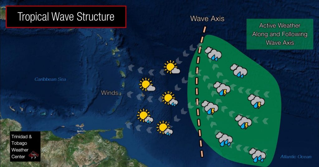
— Tropical Wave 12: Located along 52W from 15N, moving west around 10 knots (18 km/h) with scattered showers and isolated strong thunderstorms. This wave is forecast to move across the country and the Windwards on Thursday night through Friday, with much of the stronger activity moving north of Trinidad, affecting Tobago and the southern Windward Islands. There is a modest surge of winds near the wave axis, enhancing convergence.
— Tropical Wave 13: Located along 41W from 15N southward, moving west at around 10-15 knots (18 to 28 km/h), forecast to move across T&T on Monday night through Tuesday morning.
— Tropical Wave 14: Located along 27W from 16N southward, moving west at 10 to 15 knots (18-28 km/h), forecast to move across the region by next Wednesday.
An active tropical wave (TW12) is nearing the Lesser Antilles, with scattered showers and thunderstorms (some strong). While Trinidad and Tobago will experience an increase in cloudiness from Thursday afternoon as this wave approaches, most of the stronger convection (showers and thunderstorms) is forecast to remain north of the country, where upper-level conditions are more favorable, with the southernmost activity affecting Tobago. It will decrease winds across Trinidad, with winds at times from the south to southeast on Friday. Combined with warm temperatures and west-coast convergence, these veering winds through the atmosphere may lead to short-lived funnel clouds across western Trinidad on Friday afternoon.
While prolific rainfall totals are not forecast for Trinidad, this wave is forecast to produce between 25 and 50 millimeters of rainfall across Tobago to St. Vincent and the Grenadines, with locally higher totals between Grenada and St. Vincent. For T&T, peak wind gusts are forecast to be near 50 km/h, while for Grenada to St. Vincent, winds could gust up to 60 km/h.
On the heels of this tropical wave is a significant surge of Saharan Dust moving in with a ridge of high pressure across the Lesser Antilles. Dust levels will be particularly significant for the Leeward Islands and northern Windward Islands, where air quality is likely to hit unhealthy levels. Across Trinidad and Tobago, lying on the southern extent of this ridge, a marginal increase in low-level convergence and moisture advection will keep isolated showers and the odd thunderstorm on tap for both Saturday and, to a lesser extent, on Sunday.
By Monday, Tropical Wave 13 is expected to move into the area, while deep tropical moisture is forecast to move in across T&T overnight, extending into Tuesday. As a result, another mostly sunny Monday will lead to an increase in cloudiness, with isolated to scattered showers and thunderstorms mainly on Tuesday.


