


Elevated winds are declining across Trinidad and Tobago, particularly Tobago and northern areas of Trinidad on Tuesday, producing sustained winds between 30 and 40 km/h with higher gusts. As a result, the Trinidad and Tobago Meteorological Service has discontinued the High Wind Alert for the country.
On Monday, even before the alert went into effect, damaging wind gusts swept across parts of T&T, producing roof damage in southern Trinidad and sporadic reports of fallen trees across the island.
What you need to know
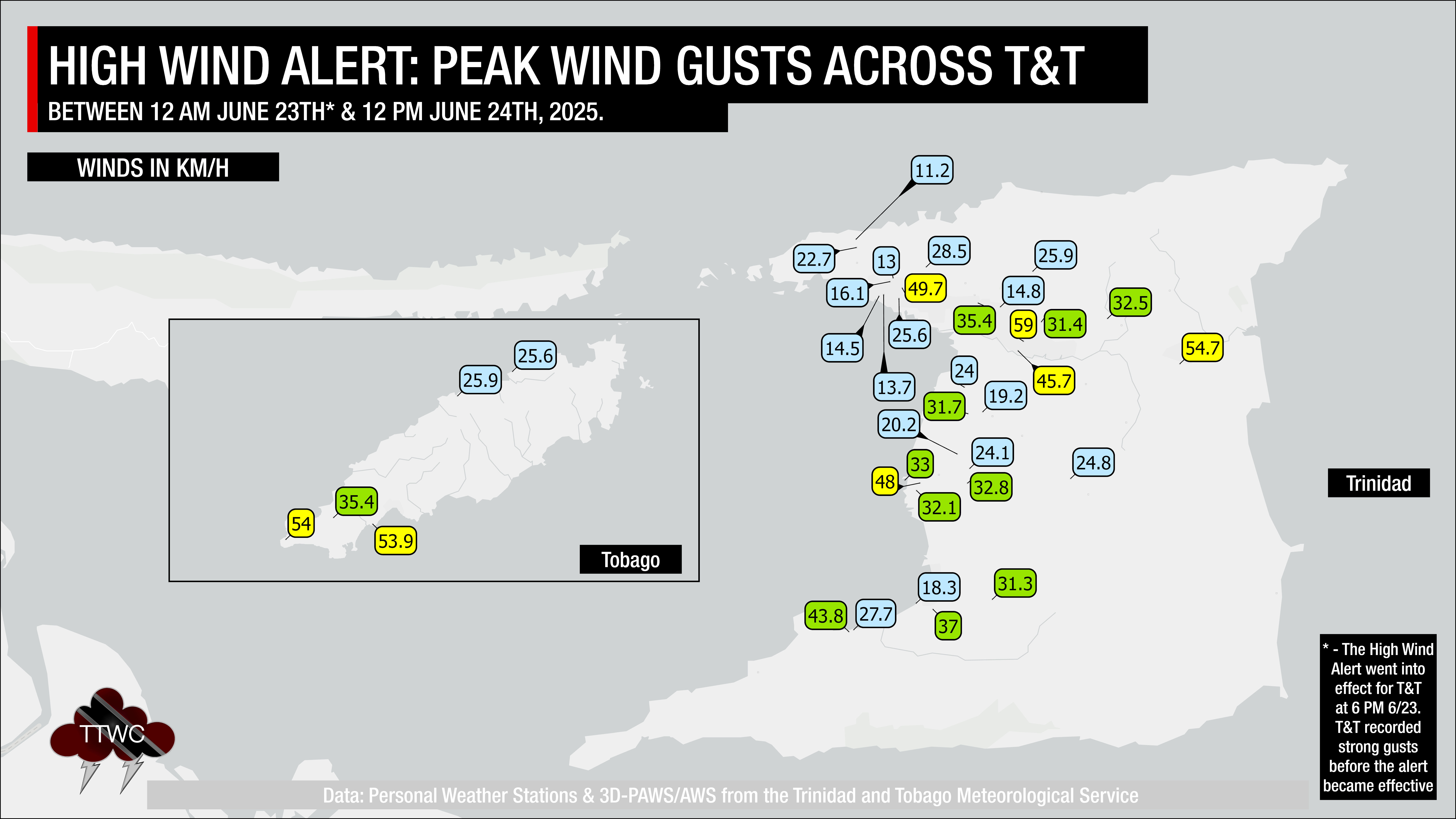
— What: A surge in winds associated with Tropical Wave 09 has moved across the Windward Islands, including Trinidad and Tobago.
— Where: Breezy to windy conditions and gusty winds occurred across the country.
— When: Occasional gusts are still possible through Wednesday, but the potential for impactful gusts has diminished.
— Impacts: Strong wind gusts can damage roofs, particularly unsecured roofs, cause loose outdoor objects to become airborne, cause tents to jump, and topple large but weaker trees and structures. Seas will become rough in open waters. A Hazardous Seas Alert is in effect.
— What Should You Do: Assess conditions in your area and keep updated with the latest weather forecasts. Marine interests should also secure marine craft and exercise heightened caution during this period.
Latest Alerts

Adverse Weather Alert Discontinued For Western Trinidad
Trinidad and Tobago is NOT under any tropical storm or hurricane threat, watch, or warning at this time.
The High Wind Alert
The Trinidad and Tobago Meteorological Service has discontinued the High Wind Alert (Yellow Level) on Tuesday, June 24th, 2025, at 3:24 PM.

“The strongest winds associated with this event have now passed. While breezy conditions may still persist and occasional gusts can occur, especially near showers, the potential for gusts exceeding 55 km/h has decreased significantly. Sea conditions remain somewhat agitated, so caution is still advised for marine interests,” according to the Trinidad and Tobago Meteorological Service.

The alert’s color indicates the severity of the event and the probability of it occurring. Currently, the alert level is Green. This means that the hazard is possible, but the severity of impacts remains at moderate for this particular alert. You should be aware of the hazards in your area, mainly with gusty winds over 55 KM/H.
These include the toppling of potted plants and light objects outdoors, falling over, or becoming airborne. Larger but weaker trees may fall, causing roof damage or downing power lines and utility poles. Unsecured roofs may be damaged. These strong winds are forecast to agitate seas and reduce visibility in marine areas.
A moderate High Wind Alert can cause injuries, and behavioral changes are required to ensure safety. Property may be damaged, and income-earning activities may be temporarily disrupted. A couple of communities are affected.
The Met Office advises the public to assess outdoor conditions, and monitor official news sources and weather updates.

