


Trinidad, Tobago, and Grenada were shaken by a light magnitude 4.9 earthquake at 4:20 PM on Tuesday, with no immediate reports of damage.
This light earthquake was reported to have been felt primarily across northern Trinidad, southern Grenada, and western areas of Tobago, with a brief, short jolt. You can submit felt reports to the University of the West Indies Seismic Research Centre.

The UWI SRC, the authority for seismic and volcanological information in the English-speaking Eastern Caribbean, has reviewed this earthquake. Upon further review, parameters like the quake’s depth, magnitude, and location may change.
There is no tsunami threat.
There are four conditions necessary for an earthquake to cause a tsunami:
- The earthquake must occur beneath the ocean or cause material to slide within or into the ocean.
- The earthquake must be strong, with at least a magnitude of 6.5.
- The earthquake must rupture the Earth’s surface and occur at a shallow depth, less than 70 kilometers below the surface.
- The earthquake must cause vertical movement of the seafloor (up to several meters).
None of these conditions occurred.
Note that different seismic monitoring agencies use different methods, or several methods, for processing quake parameters worldwide. Each method has its limitations and will likely produce different results within the range of the data’s uncertainty. This is generally accepted within the scientific community.
The United States Geological Survey (USGS) recorded this quake at a magnitude 4.4 in a similar location to the UWI SRC, at a depth of 76.8 kilometers.
Read More

Earthquake Magnitude & Intensity

Can earthquakes be predicted or forecasted?
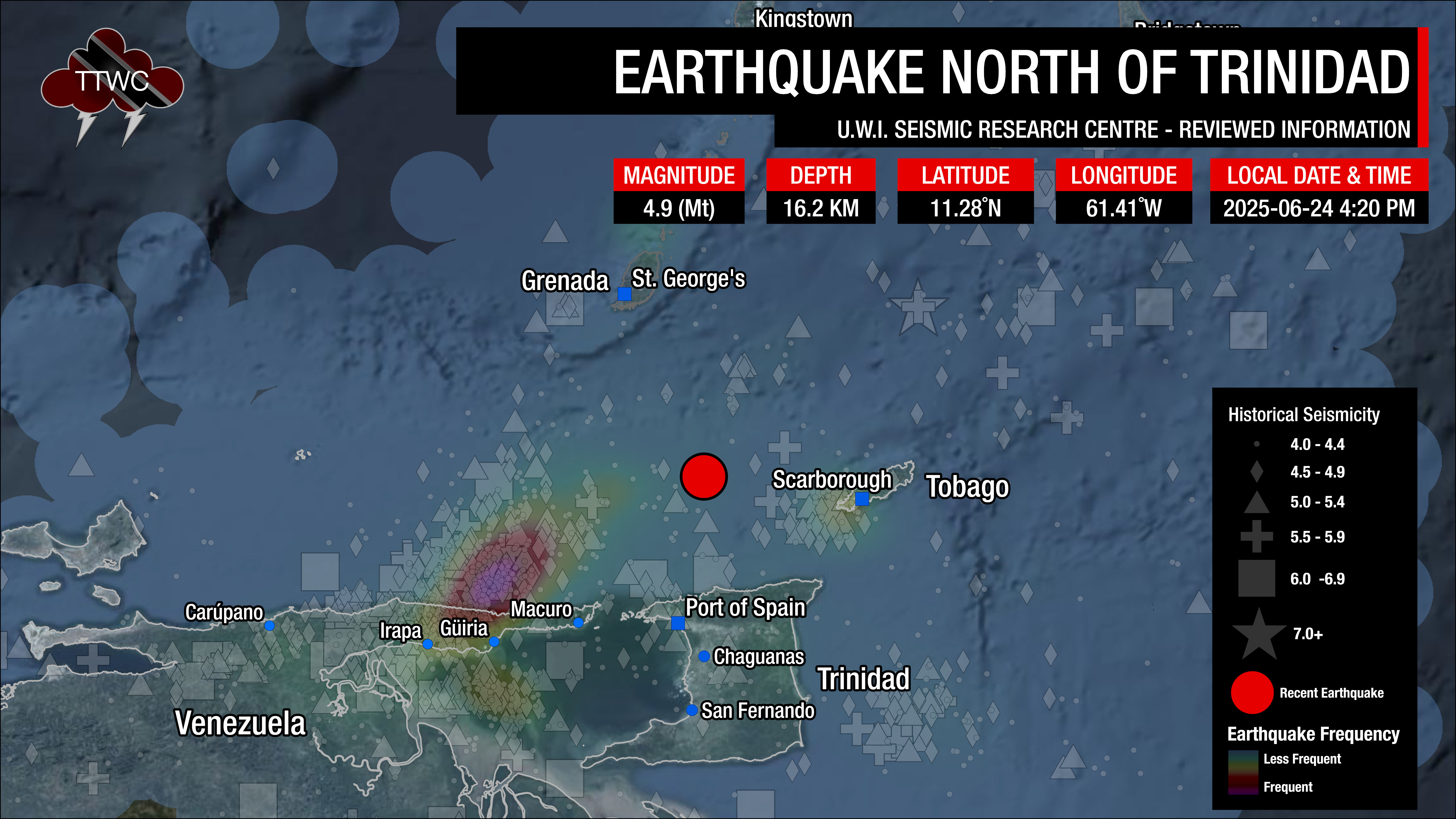
Earthquakes north of Trinidad and west of Tobago can be associated with the subducting slab of the South American Plate, resulting in a deeper hypocenter between 40-55 kilometers, but it can be deeper. Quakes in this area can also be associated with the North Coast Fault System, which runs just offshore the Northern Coast of Trinidad, where events are usually less than 40 kilometers in depth. This area typically produces light (M4.0-4.9) or moderate (M5.0-5.9) magnitude earthquakes. Earthquakes in this zone tend to make fewer aftershocks than earthquakes elsewhere across Trinidad and Tobago.
According to the UWI SRC’s profile of the area, approximately 28 events of magnitude 2.1 and above are estimated to occur annually, with an earthquake in the magnitude range of 4.6-5.0 occurring every five years, the most recent being in 2005.
The UWI SRC states that the most significant known earthquake in this area was of magnitude 6.5 and occurred on December 4, 1954. One person was killed, and many were injured. There was a significant amount of minor to moderate damage in northern Trinidad. The largest event since 1954 was a magnitude 5.2 earthquake that occurred on New Year’s Day in 1996.
This means that Tuesday’s earthquake was one of the strongest in the area in nearly 20 years. Since 1960, over 250 earthquakes have been recorded within 20 kilometers of Tuesday afternoon’s quake, most occurring between 0 and 37.5 kilometers below the Earth’s surface.
Can weather (and hot air temperatures) cause earthquakes?
The weather does not affect or cause seismic events in Trinidad and Tobago. When hot weather occurs, one of the most common comments is that it is “earthquake weather.”
It’s a fairly common misconception whose origins date back to the 4th century B.C. Aristotle proposed that earthquakes were caused by winds trapped in subterranean caves. Small tremors were thought to have been caused by air pushing on the cavern roofs, and large ones by the air breaking the surface.
This theory leads to a belief in earthquake weather that, because a large amount of air was trapped underground, the weather would be hot and calm before an earthquake. A later theory stated that earthquakes occurred in calm, cloudy conditions and were usually preceded by strong winds, fireballs, and meteors.
There is no such thing as “earthquake weather.” Statistically, there is approximately an equal distribution of earthquakes in cold weather, hot weather, rainy weather, etc.
Very large low-pressure changes associated with major storm systems (typhoons, hurricanes, etc.) are known to trigger episodes of fault slip (slow earthquakes) in the Earth’s crust. They may also trigger some damaging earthquakes. However, the numbers are small and not statistically significant.
Water can remove sediment, infiltrate the ground, and increase or decrease overburden pressures. This change in ground pressure can trigger minor seismic activity. Excessive rainfall, not hot weather, can also contribute to minor seismic activity.
Earthquake weather does not exist, and hot temperatures do not cause earthquakes.
Source: USGS
Has there been an increase in seismic activity?
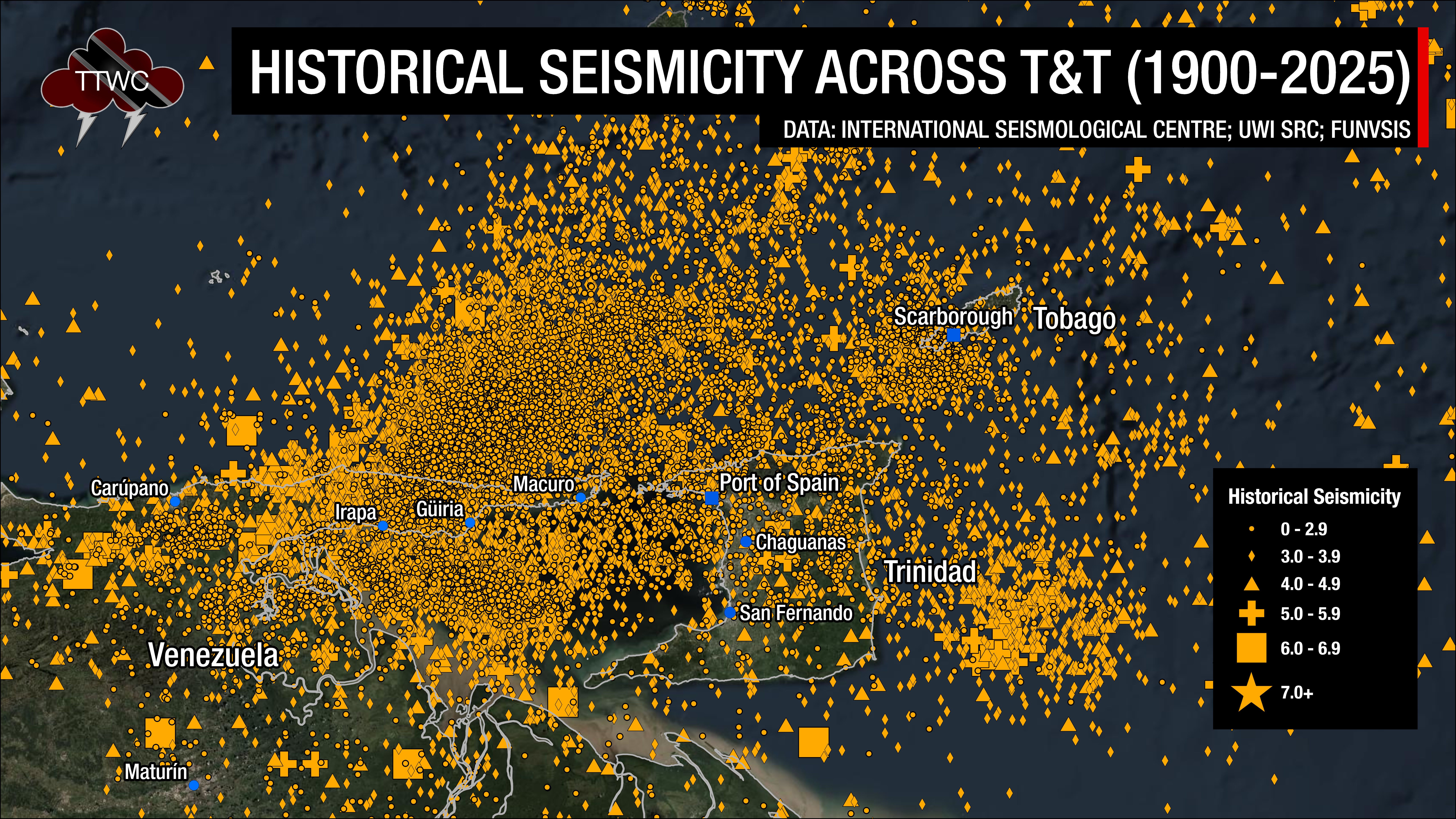
Trinidad and Tobago and the surrounding region are very seismically active. Across the Eastern Caribbean, over 2,200 earthquakes are recorded annually. Since 1990, and as of 2025, the UWI SRC has recorded an annual average of 260 earthquakes in the Trinidad and Tobago region (area bounded by 9.5°- 11.5°N & 59.5°W – 63.5°W) that are greater than magnitude 2.0.
Most earthquakes occur northwest of Trinidad in an area known as north of the Paria Peninsula, which has the second-highest seismicity in the Eastern Caribbean, and within the Gulf of Paria. According to the UWI SRC, approximately 100 quakes occur north of the Paria Peninsula annually, and 60 quakes occur within the Gulf of Paria.
With increased instrumentation (seismometers) and increased reporting on social media, while it may appear that earthquake activity in the region has risen dramatically, this is unlikely to be the case. However, the UWI SRC has repeatedly noted that since the 2000s, there has been an overall increase in seismic activity in the region.
On average, the Eastern Caribbean has seen a pattern of major (M7.0 – M7.9) quakes every 20 to 30 years. That pattern has stayed true. The last major (M7.0 – 7.9) quake occurred north of Martinique in 2007.
Historical patterns indicate that great quakes (M8.0+) on the Richter Scale have occurred every century in the region. The probability of another event at that level is high since the last >M8.0 earthquake occurred in 1843. While it is impossible to definitively say when the next great quake will occur in the region, the time since the last one is more than 170 years.
It is important to note that seismic activity cannot be predicted. Based on current research and technology, the precise time, date, magnitude, depth, etc., cannot be known ahead of time.
Now is the time to create or review your earthquake preparedness plan and know what to do during, before, and after an earthquake.
Read More

In our region, earthquakes can strike at any time and any place, so it is important to know how to keep yourself safe when one strikes.


