


The second tropical wave for the year is forecast to move across Trinidad and Tobago today. However, as is typical with these early-season waves, activity tends to be more scattered, mainly staying south of Trinidad and Tobago. However, as this wave interacts with the Intertropical Convergence Zone, activity may increase during the pre-dawn and early afternoon hours on Thursday and Friday.
By Saturday, a significant surge of Saharan Dust brings drier conditions to T&T.
What you need to know
— Rainfall: Over the next three days, through Saturday night, overall rainfall accumulations across the western half of Trinidad and Tobago are forecast to range between 15 and 25 millimeters. Mainly, but not limited to, across the eastern half of Trinidad, between 25 and 60 millimeters of rainfall is forecast, with isolated higher totals in heavy showers and thunderstorms.
— Saharan Dust: Mild dust levels through Friday, with significant Saharan Dust concentrations from daybreak on Saturday.
— Hazards: The main hazards will be street and flash flooding, primarily on Thursday night into Friday, as well as gusty winds exceeding 50 km/h, accompanied by heavy showers and thunderstorm activity on Thursday through Friday night. Seas may become locally rough or agitated in heavy shower/thunderstorm activity.
— Marine: Moderate seas are forecast in Trinidad and Tobago’s open waters, while choppy conditions are forecast in sheltered areas. All marine interests are advised to exercise caution in the vicinity of heavy showers and thunderstorms.
Latest Alerts

TTMS Issues Adverse Weather Alert For T&T
Trinidad and Tobago is NOT under any tropical storm or hurricane threat, watch, or warning at this time.
The Forecast
Thursday
ThursdayFriday
FridaySaturday
SaturdayMarine Forecast

Slight to Moderate Seas Forecast For T&T
Temperatures
Thursday
Low: 24-25°C
High: 31-33°C
Friday
Low: 24-25°C
High: 29-31°C
Saturday
Low: 24-25°C
High: 31-33°C
Forecast Impacts
Flooding
Over the next three days, through Saturday night, overall rainfall accumulations across the western half of Trinidad and Tobago are forecast to range between 15 and 25 millimeters. Mainly, but not limited to, across the eastern half of Trinidad, between 25 and 60 millimeters of rainfall is forecast, with isolated higher totals in heavy showers and thunderstorms.
Street & Flash Flooding
Street & Flash FloodingRiverine Flooding
Riverine FloodingForecast Rainfall Totals
- Thursday: Between 5 and 15 millimeters of rainfall across both islands, with isolated totals up to 25 millimeters favoring Trinidad.
- Friday: Between 5 and 20 millimeters of rainfall across both islands. Across the eastern and southern halves of Trinidad, as well as in isolated areas elsewhere, localized totals of up to 50 millimeters are possible.
- Saturday: Up to 15 millimeters across both islands, with lower accumulations across western inland areas of Trinidad and across Tobago, while higher accumulations are likely across eastern areas of Trinidad.

Understanding Rainfall Accumulations
Putting the rainfall forecast into context, rainfall rates in excess of 50 millimeters per hour or areas that receive in excess of 25 millimeters within an hour tend to trigger street flooding across the country or flash flooding in northern Trinidad. For riverine flooding to occur, a large area of the country (not just in highly localized areas of western coastal Trinidad) would have to record upwards of 75 millimeters within 24 hours, and rainfall would have to fall across major rivers’ catchment areas.

Strong Thunderstorms
Strong ThunderstormsWhat is a strong or severe thunderstorm?
Given how rare these types of thunderstorms are in our region – we classify a severe or strong thunderstorm as one that produces any of the following:
- Damaging wind gusts exceeding 63 KM/H;
- Frequent lightning (more than 30 cloud-to-ground strikes within a 10-minute period);
- Hail (of any size);
- Rainfall of more than 50 millimeters or more within an hour or exceeding 75 millimeters or more within three hours;
- The sighting of a funnel cloud or touchdown of a waterspout/tornado associated with the thunderstorm.
Gusty Winds
Gusty WindsWith wind gusts exceeding 50 KM/H, whole trees can be in motion, with larger trees and weaker branches falling. Light outdoor objects can topple or become airborne, such as garbage cans, loose galvanize, construction material, and outdoor furniture. Tents may also jump.
Other Hazards
Significant Saharan Dust is forecast to move in on Saturday, greatly degrading visibility and air quality across Trinidad and Tobago.
Saharan Dust Forecast

Dust-Free Days Ahead For T&T As Saharan Dust Stays North
Why I May Not/Will Not See Rainfall?
A frequent complaint is that the forecast is wrong because I didn’t experience any rainfall. Scattered showers mean that you, individually, may experience some showers intermittently throughout the day, and there is a higher chance for this activity than isolated activity. Widespread showers mean that nearly all persons and areas may experience rainfall.
Isolated to scattered rainfall is forecast on Thursday and Friday, with highly isolated rainfall forecast for Saturday.

Forecast Discussion
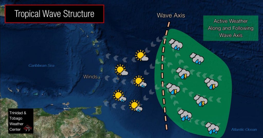
A well-defined tropical wave, tilted southwest to northeast, is moving toward Trinidad and Tobago early on Thursday morning, accompanied by abundant moisture and instability, as well as favorable upper-level divergence trailing the wave axis. Convection (showers and thunderstorms) is widely scattered, with stronger activity near the coasts of Guyana and Suriname. Ahead of tropical waves, conditions are usually calmer, with active weather following the wave axis.
This tropical wave is forecast to move across Trinidad and Tobago (T&T) later today, interacting with the Intertropical Convergence Zone (ITCZ) as it moves westward. By Thursday evening through Friday, the ITCZ is forecast to drift northward as part of the wave’s trailing convergence with an embedded low-level trough, bringing increased cloudiness, showers, and thunderstorms, with a greater impact on Friday compared to Thursday. An Adverse Weather Alert is in effect for the country from the TTMS through 4:00 PM today (Thursday). Based on the latest model trends, it is likely that if the alert isn’t outright discontinued Thursday morning and reissued for Thursday night into Friday morning, it will be extended through Friday midday. This is entirely the prerogative of the forecasters at the TTMS.
Latest forecast models indicate the heaviest rainfall is likely to occur during the overnight through early afternoon periods, in tandem with peak periods of ITCZ activity. Global models are not showing prolific rainfall totals across Trinidad and Tobago. However, 00Z May 29th runs of high-resolution models indicate 36-hour rainfall totals between Thursday morning and Friday midday nearing 100 millimeters across central and southern Trinidad, with peak activity still expected on Thursday night through Friday morning.
Drier conditions are forecast to return by Saturday as the North Atlantic high pressure ridge pushes back south with a significant surge of Saharan Dust moving in across T&T and the Lesser Antilles.


