


The 2025 Wet Season has officially begun following a multi-day rainfall event triggered by the Intertropical Convergence Zone, the first in a decade. However, significant rainfall from persistent rain, showers, isolated thunderstorms, and gusty winds damaged several homes, injured one, and left five homeless.
What Happened
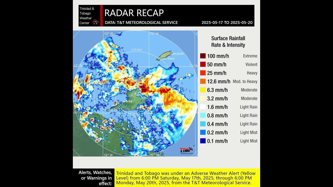
On May 16th and 17th, Trinidad and Tobago was located on the southwestern periphery of an Atlantic high-pressure ridge, leading to deep moisture from the equator and instability conflucting (slowing down and piling up like traffic on a highway) across T&T and the Windwards. This favorable confluence and convergence at the low levels were supported by a mid- to upper-level trough to T&T’s northeast, providing ample upper-level divergence. These factors come together to support persistent rain between May 17th and 18th. On day one of this rainfall event, May 17th, most of the heavier rain remained across south and central Trinidad with rainfall totals between 25 and 50 millimeters.

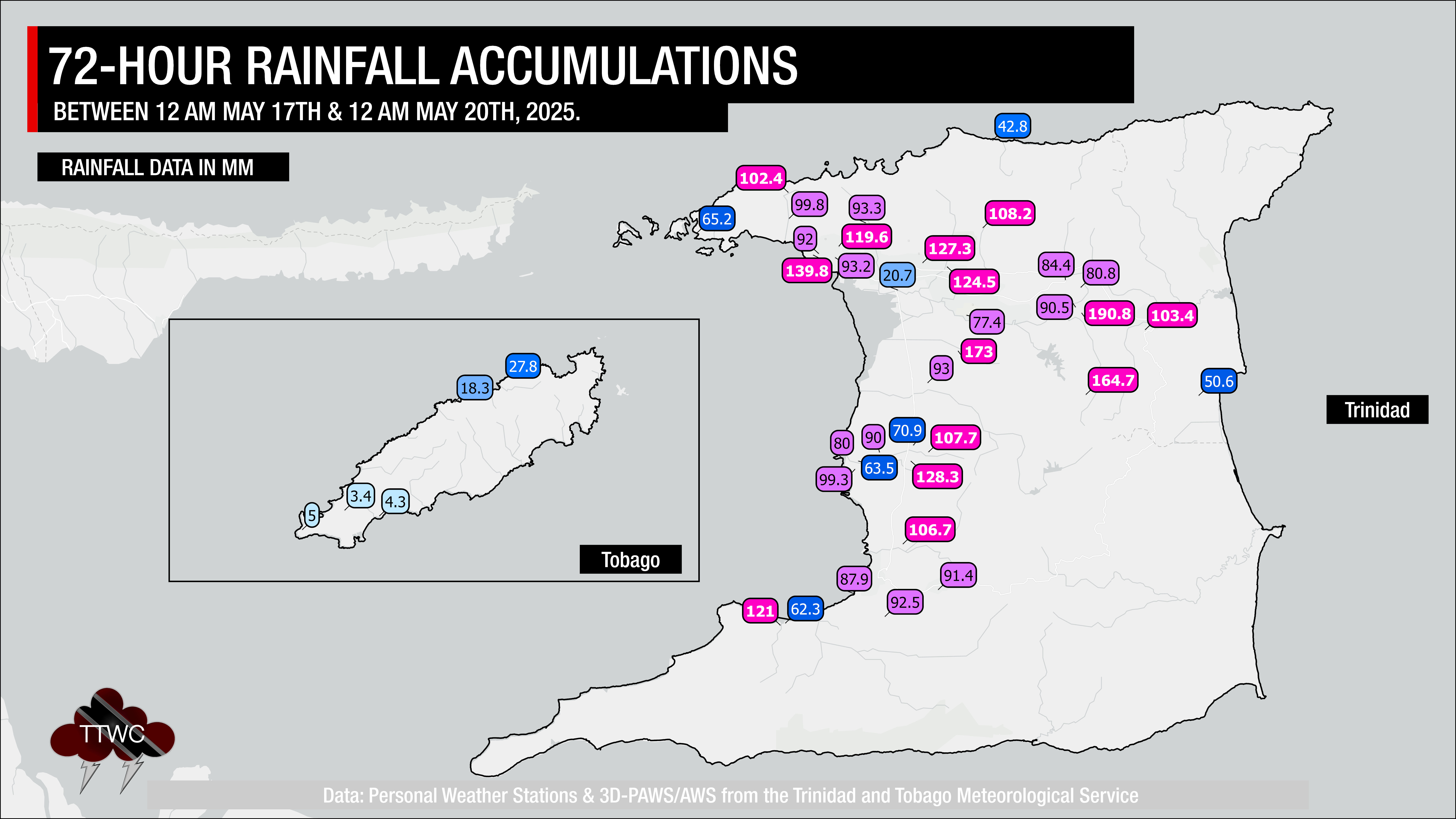
However, to the direct south of Trinidad and Tobago, the Intertropical Convergence Zone (ITCZ), an area where the northeast trade winds from the Northern Hemisphere and southeast trade winds from the Southern Hemisphere meet and converge, was gradually moving north, supplying additional moisture and instability to T&T’s atmosphere. As a result, even heavier and more persistent rain fell across Trinidad on May 18th, and to a lesser extent on May 19th as the ITCZ drifted north. One-day totals on May 18th were between 50 and 100 millimeters across most of Trinidad, with three-day rainfall totals ranging from 60 to 100 millimeters of rainfall, and in several areas, exceeding 100 millimeters of rainfall.
Read More

The Intertropical Convergence Zone (ITCZ)
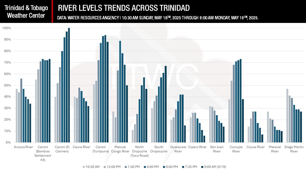
Across the Caroni and North Oropouche River Basins, where rainfall gauges were co-located, three-day rainfall accumulations exceeded 125 millimeters, sending multiple tributaries, and the Caroni River, to threshold levels. Short-lived riverine flooding occurred near El Carmen on May 19th as the Caroni River briefly overtopped. Across Southeastern Trinidad, reliable rainfall measurements were sparse, but flooding was reported across the Ortoire River and Navet River Basins and near the Morgua River.
River levels rose consistently across many river basins of Trinidad, based on data from the Water Resources Agency and shared by the Ministry of Rural Development and Local Government. The Caroni River was the only major river to briefly overtop at El Carmen overnight on May 18th into 19th and during the first half of the day.
Until the 2018 Greenvale Floods, when most of Trinidad accumulated between 150 and 300 millimeters of rainfall and isolated areas received up to 400 millimeters in just three days, the island received, on average, half that total during the same period in 2025. It should also be noted that while the rainfall totals were significant, they occurred at the start of the Wet Season, where soils are still parched from months of relatively drier weather. In contrast, the October 2018 event occurred late into a wetter-than-usual Wet Season, and most of the rain fell on the third day, when soils were mostly saturated.

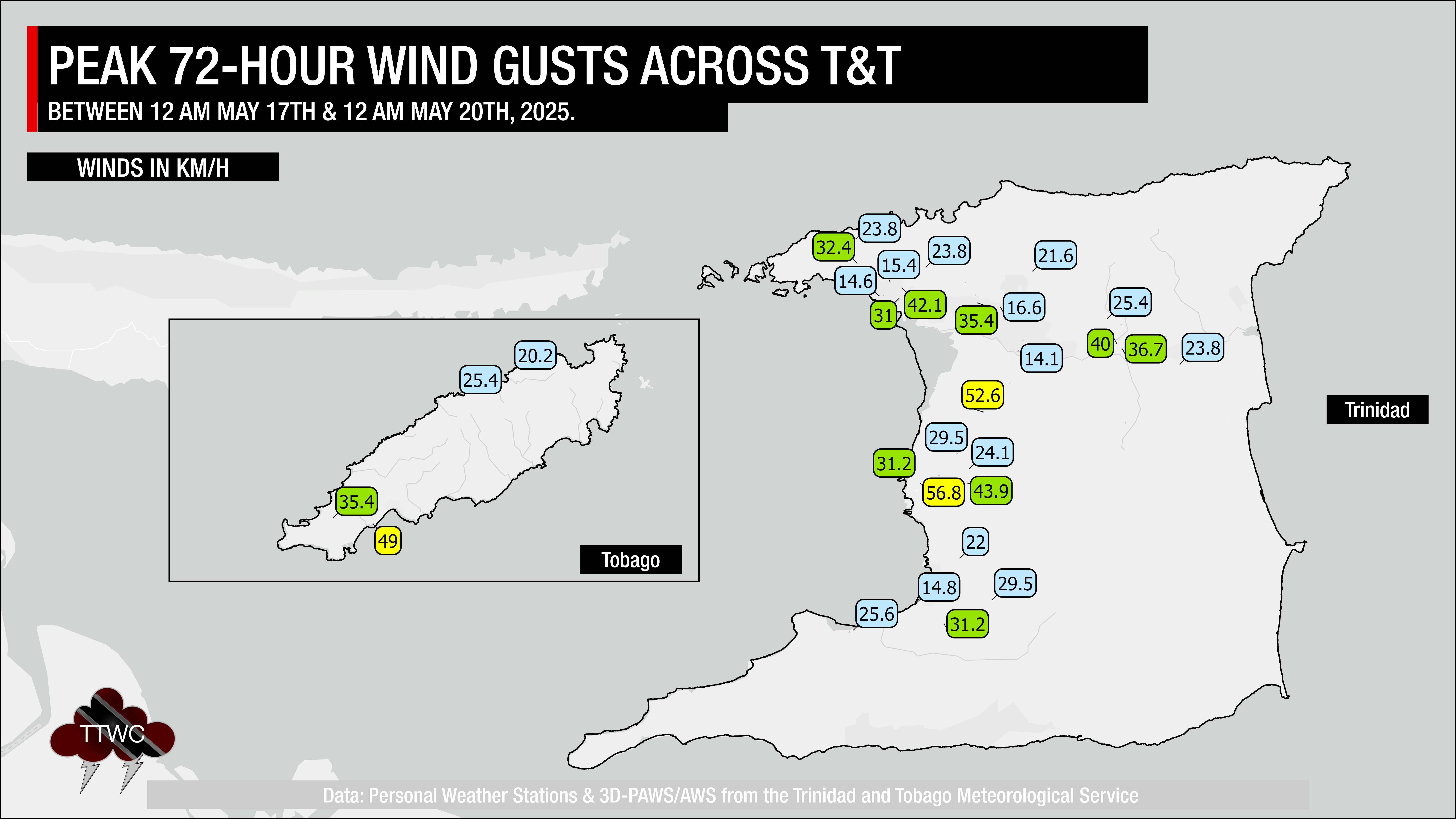
While wind speeds were moderate, peak wind gusts ranged between 35 KM/H and 60 KM/H accompanying heavy showers and isolated thunderstorms. While initial reports were primarily flooding events, as rainfall continued, there were increasing incidents of fallen trees, particularly across northern municipal corporations.
Authorities well-forecasted this event, with the Trinidad and Tobago Meteorological Service advising of heavy rainfall as early as May 12th. The first of four Adverse Weather Alerts was issued on May 16th, going into effect at 6:00 PM on May 17th. Though the alert period missed the onset of heavy rainfall, it captured the worst weather on May 18th.
Who (and Where) Were Affected

Over the three days, at least 120 inclement weather-related impacts occurred across Trinidad, while Tobago remained unscathed by the first significant rainfall event of the 2025 Wet Season.
Heavy rainfall and flooded rivers led to high turbidity and clogged screens at surface water treatment facilities across northeastern Trinidad. According to the Water and Sewage Authority, six plants were affected by 11:00 AM on May 18th and increased to 13 by 9:00 AM on May 19th.
However, the abundant rainfall wasn’t all bad news. Between May 16th and May 20th, all reservoirs across Trinidad increased their capacity between 3.5% and 8%. While these percentages sound modest, at the country’s largest dams/reservoirs, the 3.61% increase at the Caroni Arena Dam added over 360 million gallons of water, and the 7.9% increase at Navet Dam added 331.8 million gallons. In the northeast, Hollis Dam saw a 4.93% increase, or a 51.5 million gallon increase in water.
With persistent rainfall, soils became saturated, increasing the incidence of landslides and fallen trees, which damaged structures and injured one person.
Arima Borough Corporation

There was only one report of street flooding in Arima on May 18th as heavy rainfall moved through the area, affecting Santa Rosa.
Chaguanas Borough Corporation

Chaguanas saw between 25 and 75 millimeters, primarily on May 17th and 18th. As a result, there were 12 reports of flooding, primarily street floods including Chagaunas Main Road, Chan Ramlal Road, Connector Road, Crown Trace, Egypt Trace, and Endeavour Main Road, where the Lallan River burst its banks. There was also a report of a fallen tree and another of roof damage. The most significant flooding occurred along Ackbar Trace, Charlieville, making the roadway impassable.
Couva/Tabaquite/Talparo Regional Corporation

Within the Couva/Tabaquite/Talparo region, isolated three-day rainfall totals exceeded 125 millimeters further inland, with generally between 50 and 100 millimeters near western areas, all mostly leading to street flooding along Mission Road and Calcutta Road #2 within Freeport, Persevereance Road, Chanderagore, and St. John’s Road in Carapichaima, as well as parts of Enterprise, Edinburgh, and Cunupia. There was one report of roof damage, and flash flooding occurred in the very flood-prone area of the Caparo Valley Brasso Road near Breeding Unit within Mamoral. Within the region, there were four reports of fallen trees and one report of roof damage.
Diego Martin Borough Corporation

Street and flash flooding initially occurred within the Diego Martin Borough Corporation, affecting parts of the Diego Martin Main Road and 11 other areas. The more persistent rainfall followed, and soils became saturated, leading to at least 10 reports of trees falling, including Petit Valley and Maraval, seven reports of roof damage, and six reports of landslides.

Mayaro/Rio Claro Regional Corporation

Across the southeastern area of Trinidad, reliable rainfall measurements are sparse. With this initial three-day rain spell, rivers neared threshold levels, with mainly unpopulated areas seeing impacts from elevated watercourses. However, street flooding was reported in Crapaud Flats and Rampaul Trace in Navet, as well as along the Rio Claro Guayaguayare Road and Poole Valley Trace, Rio Claro where two feet of flood water was reported.
Penal/Debe Regional Corporation

Only minor street flooding was reported within the PDRC area of responsibility, along Scott Road and Penal Rock Road, near the five-mile marker.
Port of Spain City Corporation

Similarly, only short-lived, minor street flooding was reported within the capital, along Richmond Street and Independence Square.
Princes Town Regional Corporation

Princes Town was arguably the hardest hit, though overall incident reports were low. A house fire in Buen Intento left three homeless, while two were left homeless after their roof caved in at La Ruffin, Moruga. Flooding was also reported at Gaffoor Trace, Tableland, and there were also two reports of roof damage.
Siparia Borough Corporation

Within the Siparia Borough, only one tree was reported fallen, and one street was flooded.
Sangre Grande Regional Corporation

Most rivers remained within their banks across the large Sangre Grande Regional Corporation, with only smaller tributaries (excluding the Cunapo River) flooding low-lying areas. At least one flooding report was in Coal Mine, and fallen trees were reported along the Cumuto Main Road, with another at Mahaboo Trace.
San Juan/Lavantille Regional Corporation

Similarly to the Diego Martin Borough Corporation, as soils became saturated, landslide reports increased, ending as of May 20th at eight landslide events. In Eastern Quarry, Lavantlle, a 44-year-old woman was injured after a landslide destroyed their home.

There were three reports of structural damage, two reports of roof damage, and eight reports of flooding, including Sun Valley Road, Mt. D’or Road, Fondes Armandes Road, and 7th Avenue in Malick.
Tunapuna/Piarco Regional Corporation

Eight reports of fallen trees were received across the Tunapuna/Piarco Regional Corporation, including along Caura Royal Road, Caura; Andrew Lane and Olton Road, D’Abadie; and Freeman Road, St. Augustine. Flash flooding was also reported at Freeman Road, Tumpuna Road South, Bamboo #3, and Factory Road Extension South. Several areas along the Caroni River, mainly low-lying farmland and floodplains, were also inundated.
What’s Next
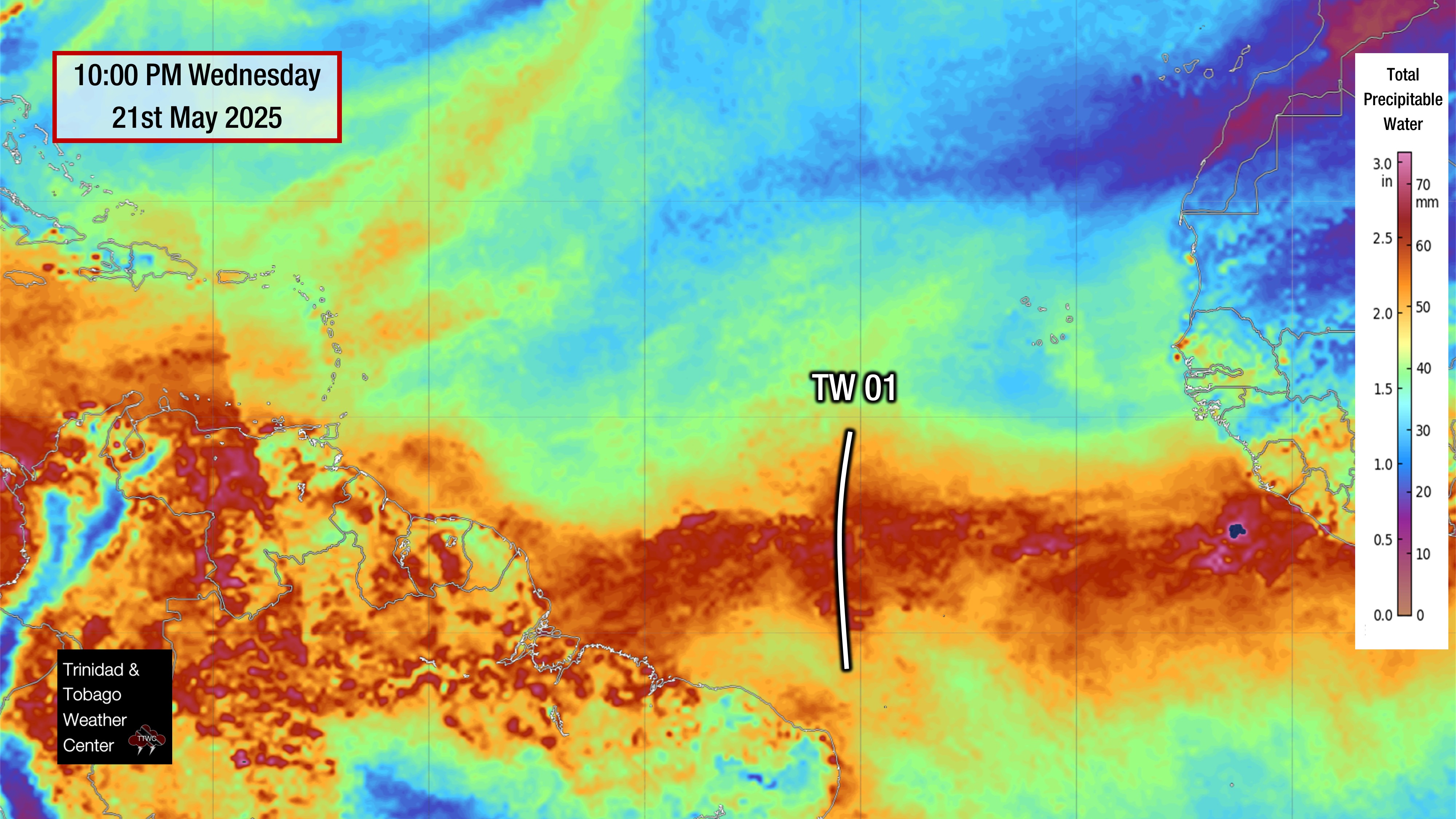
The first tropical wave of the 2025 Atlantic Hurricane Season is en route to the Windward Islands, including Trinidad and Tobago. It is forecast to bring rainfall to the country beginning on Sunday, May 25th, 2025. Based on the latest forecast guidance, showers and isolated thunderstorms are likely between May 25th and May 26th. However, significant, multi-day rainfall is not likely with total 48-hour rainfall accumulations between 25 and 50 millimeters, and isolated higher totals favoring southern and eastern Trinidad and localized areas along western coastal Trinidad.