


What you need to know
— River Levels: The Caroni River has overtopped at El Carmen, but all other major rivers remain contained at this time with no extensive riverine flooding expected.
— Rainfall: Through Tuesday night, forecast models indicate an additional 10-25 millimeters of rainfall across most of Trinidad and Tobago.
— Hazards: The main hazards are now all modalities of flooding—street/flash floods in heavy showers and thunderstorms, and riverine flooding, particularly near smaller watercourses that are already at threshold and low-lying areas near major watercourses. Due to soil saturation, landslides in elevated areas, primarily across Trinidad, and falling trees are possible. Gusty winds remain a risk in heavy showers and thunderstorms, which can also agitate seas.
Latest Alerts

TTMS Issues Adverse Weather Alert For T&T
Trinidad and Tobago is NOT under any tropical storm or hurricane threat, watch, or warning at this time.
The Adverse Weather Alert
The Trinidad and Tobago Meteorological Service updated the Adverse Weather Alert (Yellow Level) on Monday, May 19th, 2025, at 7:56 AM, discontinuing the alert for Tobago. However, it remains in effect for Trinidad through 6:00 PM today, May 19th, 2025.
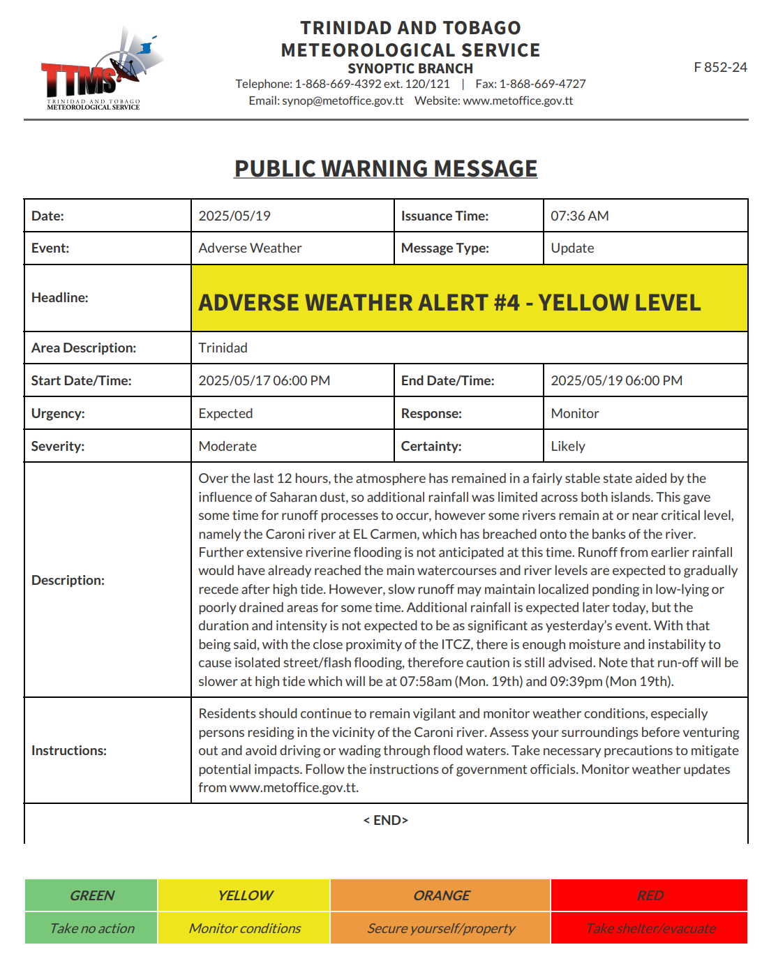
According to the TTMS, “Over the last 12 hours, the atmosphere has remained in a fairly stable state aided by the influence of Saharan dust, so additional rainfall was limited across both islands. This gave some time for runoff processes to occur, however some rivers remain at or near critical level, namely the Caroni river at EL Carmen, which has breached onto the banks of the river. Further extensive riverine flooding is not anticipated at this time. Runoff from earlier rainfall would have already reached the main watercourses and river levels are expected to gradually recede after high tide. However, slow runoff may maintain localized ponding in low-lying or poorly drained areas for some time. Additional rainfall is expected later today, but the duration and intensity is not expected to be as significant as yesterday’s event. With that being said, with the close proximity of the ITCZ, there is enough moisture and instability to cause isolated street/flash flooding, therefore caution is still advised. Note that run-off will be slower at high tide which will be at 07:58am (Mon. 19th) and 09:39pm (Mon 19th).”

The alert’s color indicates the severity of the event and the probability of its occurrence. Currently, the alert level is Yellow. This means that the hazards are likely, and the severity of the impacts is moderate for this particular alert. You should be aware of the hazards in your area, which are associated mainly with street/flash flooding as well as riverine flooding, gusty winds, falling trees, landslides, and agitated seas.
A moderate Adverse Weather Alert can result in possible injuries and behavioral changes, which are required to ensure safety. Minor damage to property may also occur, temporarily disrupting income-earning activities and affecting a couple of communities.
The Met Office advises the public to continue to remain vigilant and monitor weather conditions, assess their surroundings before venturing out, avoid driving or wading through flood waters, take necessary precautions to mitigate potential impacts, follow the instructions of government officials, and monitor weather updates.


