


Through Tuesday, the Intertropical Convergence Zone (ITCZ) lingers just south of Trinidad, supplying abundant moisture and instability, while upper levels of the atmosphere support showers and thunderstorms. Parts of T&T are forecast to receive notable rainfall over the next two to three days.
May is typically the transition month into the local Wet Season, which is triggered by either the passage of a tropical wave (none has formed and moved off the African coast yet), which is more common, or the movement of the ITCZ over the country, which produces rainfall. The last time the Wet Season was triggered by the ITCZ was in 2016.
Whether the Wet Season is declared or not, the forecast remains for wet weather through Tuesday, with flooding concerns particularly for southern and central Trinidad.
What you need to know
— Rainfall: Over the next five days, through Thursday, May 22nd, overall rainfall accumulations across the country are forecast to range between 25 and 75 millimeters of rainfall across most of Trinidad and Tobago, with lower accumulations across northern Trinidad and Tobago, while across the southern half of Trinidad, rainfall totals between 75 and 150 millimeters are forecast. Isolated higher totals, exceeding 150 millimeters, are possible across south-central and southwestern Trinidad, with most of the rain accumulating between Sunday and Tuesday.
— Saharan Dust: Mild to moderate Saharan Dust concentrations are forecast through the next five days.
— Hazards: The main hazards will be street/flash flooding and gusty winds exceeding 50 KM/H accompanying heavy shower and thunderstorm activity. As soils become increasingly saturated, landslides are also possible in elevated southern and eastern areas, with river levels needing close monitoring, particularly in central and southern areas. Seas may become locally rough or agitated in heavy shower/thunderstorm activity.
— Marine: Moderate seas are forecast in Trinidad and Tobago’s open waters, while choppy conditions are forecast in sheltered areas. All marine interests are advised to exercise caution in the vicinity of heavy showers and thunderstorms.
Latest Alerts

Adverse Weather Alert Discontinued For Western Trinidad
Trinidad and Tobago is NOT under any tropical storm or hurricane threat, watch, or warning at this time.
The Forecast
Sunday
SundayMonday
MondayTuesday
TuesdayWednesday
WednesdayThursday
ThursdayMarine Forecast

Slight to Moderate Seas Forecast For T&T
Temperatures
Sunday
Low: 24-28°C
High: 29-31°C
Monday
Low: 23-26°C
High: 29-31°C
Tuesday
Low: 23-26°C
High: 30-32°C
Wednesday
Low: 24-28°C
High: 31-33°C
Thursday
Low: 24-28°C
High: 31-33°C
Forecast Impacts
Flooding
Over the next five days, through Thursday, May 22nd, overall rainfall accumulations across the country are forecast to range between 25 and 75 millimeters of rainfall across most of Trinidad and Tobago, with lower accumulations across northern Trinidad and Tobago, while across the southern half of Trinidad, rainfall totals between 75 and 150 millimeters are forecast. Isolated higher totals, exceeding 150 millimeters, are possible across south-central and southwestern Trinidad, with most of the rain accumulating between Sunday and Tuesday.
Street & Flash Flooding
Street & Flash FloodingRiverine Flooding
Riverine FloodingForecast Rainfall Totals
- Sunday: Across Tobago, less than 10 millimeters. Across northern Trinidad, between 10 and 25 millimeters. Across central, southern, and localized western areas of Trinidad, between 25 and 75 millimeters of rainfall, with higher totals favoring southwestern and southern coastal areas.
- Monday: Across Tobago and the northern half of Trinidad, between 5 and 15 millimeters, with totals across the southern half of Trinidad between 15 and 35 millimeters. Isolated higher totals are possible favoring southern coastal areas of Trinidad.
- Tuesday: Across Tobago, up to 10 millimeters. Across, Trinidad, between 10 and 25 millimeters of rainfall with isolated totals up to 40 millimeters favoring southern and western areas.
- Wednesday: Up to 5 millimeters across the country, with isolated totals between 10 and 25 millimeters favoring eastern and western coastal areas of Trinidad.
- Thursday: Up to 5 millimeters across the country, with isolated totals up to 10 millimeters favoring southern areas.

Understanding Rainfall Accumulations
Putting the rainfall forecast into context, rainfall rates in excess of 50 millimeters per hour or areas that receive in excess of 25 millimeters within an hour tend to trigger street flooding across the country or flash flooding in northern Trinidad. For riverine flooding to occur, a large area of the country (not just in highly localized areas of western coastal Trinidad) would have to record upwards of 75 millimeters within 24 hours, and rainfall would have to fall across major rivers’ catchment areas.

Strong Thunderstorms
Strong ThunderstormsWhat is a strong or severe thunderstorm?
Given how rare these types of thunderstorms are in our region – we classify a severe or strong thunderstorm as one that produces any of the following:
- Damaging wind gusts exceeding 63 KM/H;
- Frequent lightning (more than 30 cloud-to-ground strikes within a 10-minute period);
- Hail (of any size);
- Rainfall of more than 50 millimeters or more within an hour or exceeding 75 millimeters or more within three hours;
- The sighting of a funnel cloud or touchdown of a waterspout/tornado associated with the thunderstorm.
Gusty Winds
Gusty WindsWith wind gusts exceeding 55 KM/H, whole trees can be in motion, with larger trees and weaker branches falling. Light outdoor objects can topple or become airborne, such as garbage cans, loose galvanize, construction material, and outdoor furniture. Tents may also jump.
Other Hazards
Saharan Dust levels are forecast to remain mild to moderate through the forecast period, leading to moderate air quality.
Saharan Dust Forecast

Dust-Free Days Ahead For T&T As Saharan Dust Stays North
Why I May Not/Will Not See Rainfall?
A frequent complaint is that the forecast is wrong because I didn’t experience any rainfall. Scattered showers mean that you, individually, may experience some showers intermittently throughout the day, and there is a higher chance for this activity than isolated activity. Widespread showers mean that nearly all persons and areas may experience rainfall.
Scattered to widespread rainfall is forecast on Sunday and Monday, with isolated rainfall forecast Tuesday through Wednesday.

Forecast Discussion
Trinidad and Tobago is located on the southwestern periphery of a deep-layered high-pressure ridge in the North Atlantic. As a result, low and mid-level winds have been pushing abundant moisture and instability from the equator northward across T&T, with the Intertropical Convergence Zone lying just to T&T’s south. Also at the low levels is favorable low-level convergence and confluence, supporting the development of showers and thunderstorms. At the mid- to upper-level, a trough system is enhancing those showers and thunderstorms that develop, moving from southeast to northwest over the last several hours.
As a result, bursts of deep convection (heavy showers and thunderstorms) are forecast to continue across Trinidad, particularly the southern and central thirds of the island, with a lesser extent across northern areas of Trinidad and Tobago. This pattern is forecast to remain through Tuesday, as abundant moisture and instability remain present, with favorable atmospheric support at all levels of the atmosphere. An Adverse Weather Alert is in effect for the country from the TTMS, which has been advising the public of wet weather for the last several days.
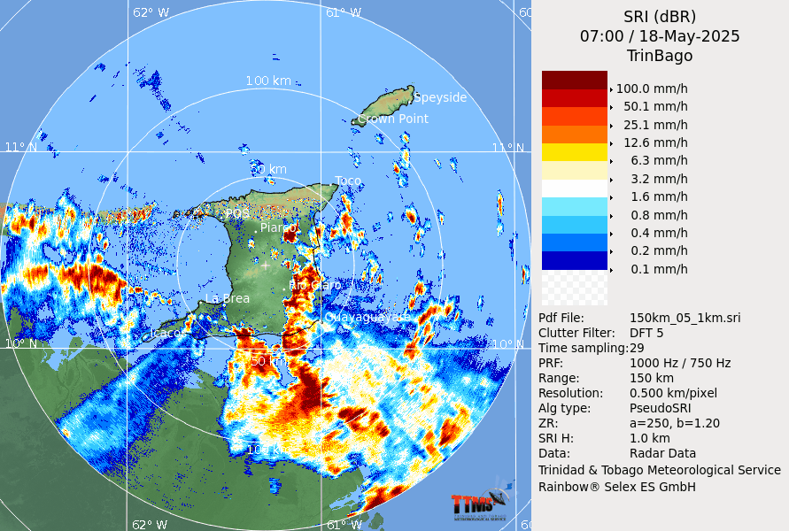
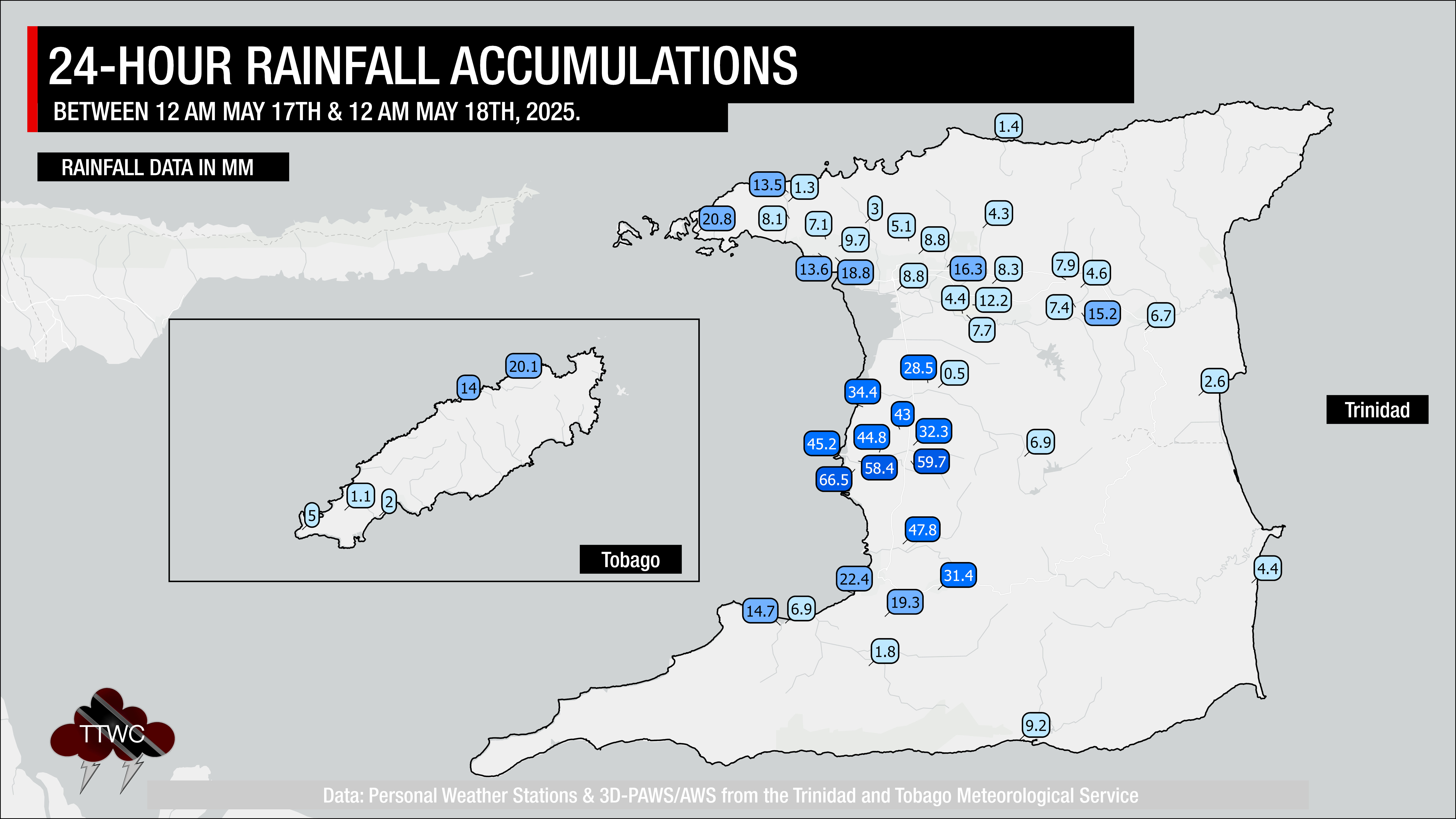
We’ve already seen the “training” of showers and thunderstorms moving across Trinidad on Sunday morning. Training in this context is when showers/thunderstorms move over the same areas repeatedly, like cars on a train, which can produce significant rainfall totals. So far, this activity has produced an additional 25-40 millimeters of rainfall before 7:00 AM in parts of southern and central Trinidad, while Tobago remains mostly dry. The ECMWF model has been maintaining total rainfall accumulations remaining below 100 millimeters across a wide swath of central and southern Trinidad through Wednesday, which is sufficient for causing short-lived (less than 24 hours) riverine flooding in several river basins. The GFS model is showing a more prolific rainfall event, with isolated totals up to 300(!) millimeters across the South Oropouche River Basin, likely picking up on the ongoing training pattern of rainfall.
Regardless of the eventual total, it is appearing increasingly likely that this rainfall event will lead to multiple areas across Trinidad experiencing at least street/flash flooding through Tuesday. Those in low-lying areas, especially those in south and central Trinidad, will need to pay extremely close attention to watercourses through Wednesday.
Drier conditions are forecast to return by Wednesday as the North Atlantic high pressure ridge pushes back south, moving the abundant moisture back toward the equator.


