


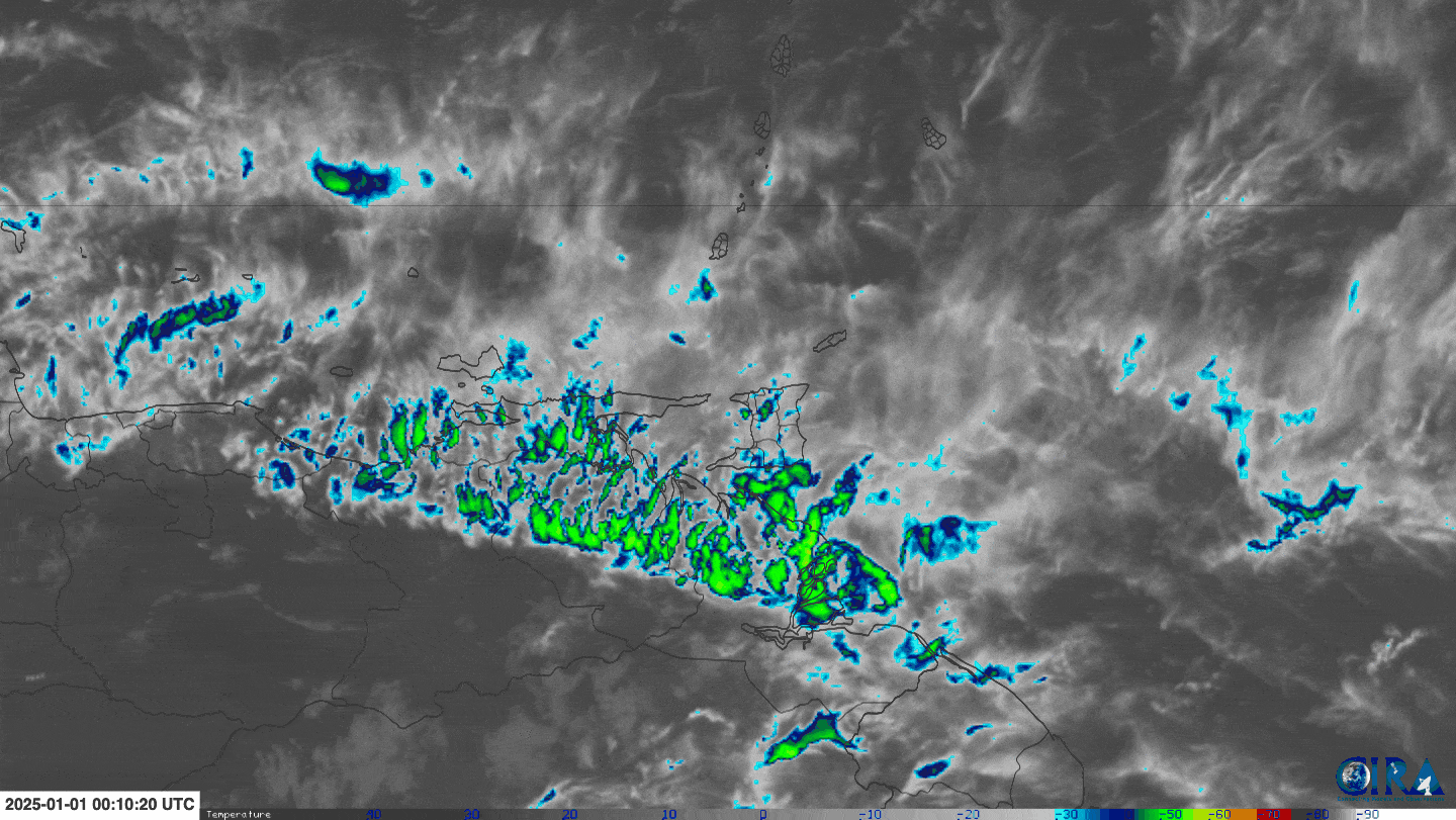
Trinidad and Tobago is forecast to have a wet start to 2025. It is located in an area with favorable upper-level conditions, abundant moisture, and convergence, leading to periodic showers and occasional thunderstorms.
With rainfall forecast over the next three days, soils are forecast to become increasingly saturated, leading to an elevated risk of flooding and landslides. As a result, the Trinidad and Tobago Meteorological Service has issued an Adverse Weather Alert for Trinidad, but this will likely be expanded by Thursday.
What you need to know
— Rainfall: Through Saturday morning, forecast models indicate between 25 and 50 millimeters of rainfall across most of Trinidad and Tobago, with lower accumulations across interior areas of Trinidad, particularly across the western half of Trinidad. Isolated totals between 50 and 100 millimeters are forecast across the southern and eastern halves of Trinidad and eastern Tobago.
— Hazards: The main hazards will be localized street/flash flooding and gusty winds exceeding 40 KM/H accompanying heavy shower and thunderstorm activity. Due to increasingly saturated conditions from this week’s upcoming rainfall, landslides are also possible in elevated southern and eastern areas. Seas may become locally rough or agitated in heavy shower/thunderstorm activity.
Latest Alerts

Adverse Weather Alert Discontinued For Trinidad, Rainfall Still Forecast
Trinidad and Tobago is NOT under any tropical storm or hurricane threat, watch, or warning at this time.
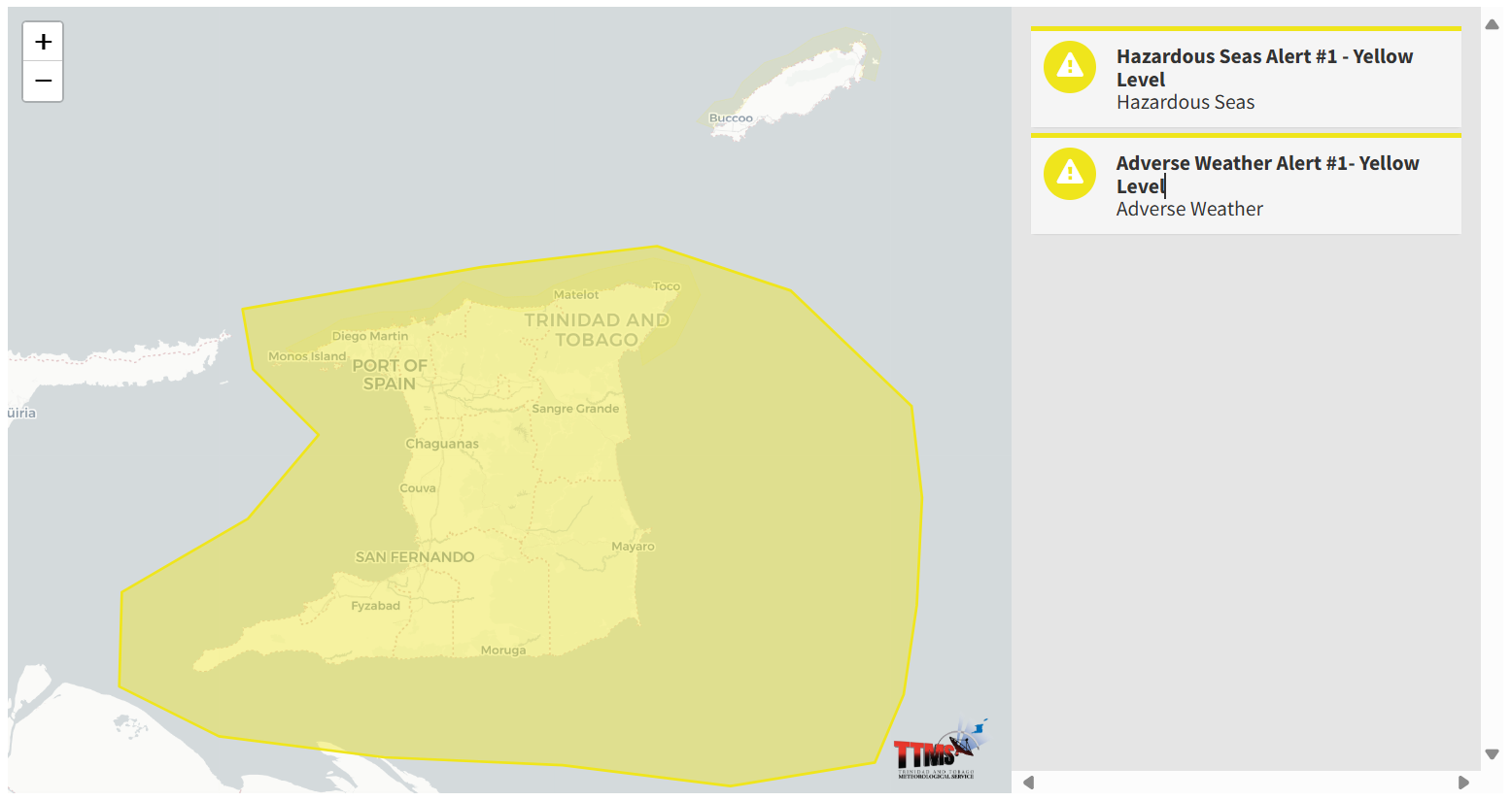
The Adverse Weather Alert
The Trinidad and Tobago Meteorological Service issued an Adverse Weather Alert (Yellow Level) on Wednesday, January 1st, 2025, at 10:44 AM for Trinidad. The alert retroactively went into effect for Trinidad and remains effective through 6:00 PM Friday, January 3rd, 2025.

As mentioned earlier, the inclement weather forecast is due to a very moist and unstable atmosphere across Trinidad and Tobago.
This “alert” status considers the possibility of the event occurring. This adverse weather event is likely, and the following impacts are likely, according to the TTMS:
- Over the next three days, periods of rainfall, with a moderate chance of isolated heavy showers or thunderstorms, are expected to intermittently affect Trinidad and off-shore areas, east and south.
- These conditions could still result in localized flooding, ponding, landslides or landslips in vulnerable areas and gusty winds during heavier downpours.
- The current weather pattern, enhanced by favorable atmospheric conditions, is supporting increased and prolonged rainfall activity.

The alert’s color indicates the severity of the event and the probability of its occurrence. Currently, the alert level is Yellow. This means that the hazards are likely, and the severity of the impacts is moderate for this particular alert. You should be aware of the hazards in your area, which are associated mainly with street/flash flooding, gusty winds near and above 40 KM/H, possibly falling trees, and agitated seas.
A moderate Adverse Weather Alert can result in possible injuries and behavioral changes, which are required to ensure safety. Minor damage to property may also occur, temporarily disrupting income-earning activities and affecting a couple of communities.
The Met Office advises the public to continue to remain vigilant and monitor weather conditions, assess their surroundings before venturing out, avoid driving or wading through flood waters, take necessary precautions to mitigate potential impacts, follow the instructions of government officials, and monitor weather updates.


