


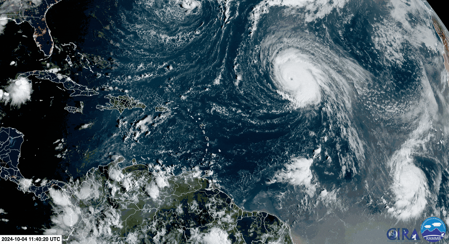
Hurricane Kirk is a formidable Category 4 storm with maximum sustained winds near 220 KM/H and higher gusts. Kirk continues to produce large waves near the system’s core, but long-period swells are propagating away toward the Lesser and Greater Antilles this weekend through early next week.
These swells are producing large, battering waves primarily along the north-facing coastlines of Trinidad and Tobago and, to a lesser extent, by Sunday, the north-facing coastlines of the Gulf of Paria.
What you need to know
— What is happening: Long-period swells up to 15 seconds are affecting northern coastlines, moving in from the north, combined with spring tides through tomorrow.
— What can we expect: Open water waves are forecast to remain between 1.0 and 2.0 meters, while a combination of swells and spring tides are forecast to produce occasional large, battering waves in nearshore areas through Monday, according to the alert. Forecast models show high-energy swells continuing through the end of next week as both Hurricane Kirk and soon-to-be Hurricane Leslie remain in the open Atlantic. There is an increased risk of rip currents and potentially dangerous conditions for small craft operators.
Latest Alerts

TTMS Issues Adverse Weather Alert For T&T
Trinidad and Tobago is NOT under any tropical storm or hurricane threat, watch, or warning at this time.
The Hazardous Seas Alert
The Trinidad and Tobago Meteorological Service updated the Hazardous Seas Alert (Yellow Level) on Friday at 9:25 AM. The alert went into effect for northern coastal areas of Trinidad and Tobago at 8:00 PM Thursday, October 3rd, 2024, and remains in effect through 12:00 PM (noon) Monday, October 7th, 2024.


According to the Trinidad and Tobago Meteorological Service:
- Long-period north-easterly swells are affecting near-shore north-facing Trinidad and Tobago coastal areas. These swells are being generated by Hurricane Kirk, located in the Mid-Atlantic Ocean.
- Impacts: Battering waves at the affected shorelines can be exacerbated at high tides. Near-shore activities (fishing, sea-bathing, mooring of boats, etc.) can be adversely affected.

The alert’s color indicates the event’s severity and probability of the event occurring. Currently, the alert level is Yellow. This means that the hazards have been observed, and the severity of impacts is moderate for this particular alert.
There is an increased risk of strong rip currents, which pose a serious hazard to swimmers and beachgoers. Rip currents can be life-threatening even for experienced swimmers. Agitated seas are likely to be particularly perilous for offshore activities, including fishing and other small craft marine interests. Due to the presence of spring tides, conditions at seawalls along affected coastlines can be exacerbated, especially at high tide.
For a moderate Hazardous Seas Alert, there is the potential for possible injuries, where behavioral changes are required to ensure safety. There may be minor damage to property, with income-earning temporarily disrupted and a couple of communities affected.
The Met Office advises all marine interests to monitor sea conditions and exercise caution along affected areas.


