


The active weather pattern continues across Trinidad and Tobago as a tropical disturbance moves north.
T&T is located where deep-layered moisture, high instability, low wind shear, and favorable upper and low-level conditions interact while an approaching tropical wave interacts with the Intertropical Convergence Zone. As a result, scattered showers and thunderstorms have affected the country since mid-Sunday, and additional intense activity is likely overnight.
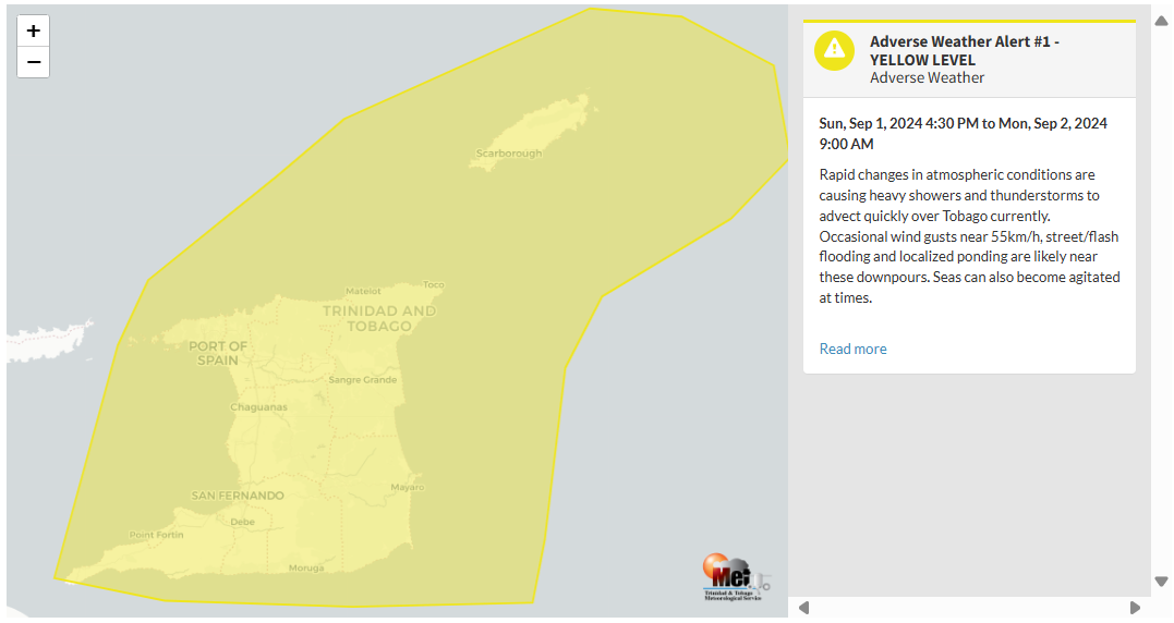
Because of the potential for impactful weather, the Trinidad and Tobago Meteorological Service has issued an Adverse Weather Alert for Trinidad and Tobago, but mainly for northern and eastern areas.
What you need to know
— Rainfall: Over the next 24 hours, forecast models show rainfall accumulations across Trinidad and Tobago generally remaining less than 25 millimeters (1 inch), but across northern and eastern areas, isolated areas can see localized rainfall totals as high as 125 millimeters (5 inches).
— Hazards: Due to periods of heavy/violent rainfall, street/flash flooding is highly likely. Wind gusts up to 55 KM/H are possible in heavy showers and thunderstorms, with frequent cloud-to-ground lightning possibly in thunderstorm activity. With the potential for intense rainfall in elevated areas of Trinidad and Tobago, landslides are possible. Seas are forecast to become locally agitated during heavy showers or thunderstorms. Funnel cloud and waterspout development also remain possible.
Latest Alerts

Adverse Weather Alert Discontinued For Western Trinidad
Trinidad and Tobago is NOT under any tropical storm or hurricane threat, watch, or warning at this time.
The Adverse Weather Alert
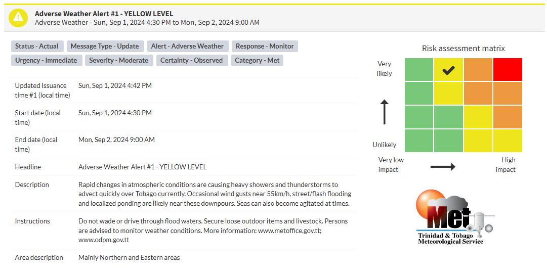
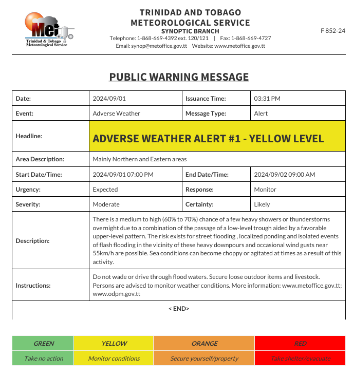
The Trinidad and Tobago Meteorological Service first issued an Adverse Weather Alert (Yellow Level) on Sunday at 3:31 PM, initially placing the country under the alert from 7:00 PM Sunday, September 1st, 2024, through 9:00 AM Monday, September 2nd, 2024.
However, by 4:42 PM, due to “rapid changes in atmospheric conditions,” the Trinidad and Tobago Meteorological Service updated the alert, retroactively placing the country under the alert period from 4:30 PM Sunday, September 1st, 2024, through 9:00 AM Monday, September 2nd, 2024.
Though the alert is slated to end at 9:00 AM officially, additional inclement weather is forecast through Monday afternoon as this strong tropical wave moves across the Windwards.
As mentioned earlier, the forecast of inclement weather is due to several weather features affecting Trinidad and Tobago.
This “alert” status considers the possibility of the event occurring. This adverse weather event has been observed, and the following impacts are very likely/observed, according to the TTMS:
- Gusty winds near 55 KM/H are possible, which can cause broken tree branches and the displacement of loose/unsecured items.
- Street flooding, localized ponding, and isolated flash flooding events near these heavy downpours.
- Sea conditions can sometimes become choppy or agitated due to this activity.

The alert’s color indicates the severity of the event and the probability of its occurrence. Currently, the alert level is Yellow. This means that the hazards are very likely or observed, and the severity of the impacts is moderate for this particular alert. You should be aware of the hazards in your area, which are associated mainly with street/flash flooding, landslides, gusty winds near 55 KM/H, possibly falling trees, and agitated seas.
A moderate Adverse Weather Alert can result in possible injuries, and behavioral changes are required to ensure safety. Minor damage to property may also occur, temporarily disrupting income-earning activities and affecting a couple of communities.
The Met Office advises the public not to wade or drive through flood waters. Secure loose outdoor items and livestock. Persons are advised to monitor weather conditions.


