


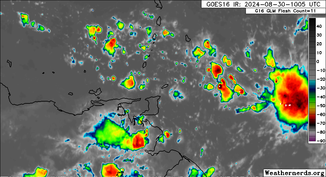
Deep-layered moisture and instability associated with the monsoon trough, an area of convergence similar to the ITCZ, remain across Trinidad, Tobago, and the Windwards. Because of the potential for impactful weather, the Trinidad and Tobago Meteorological Service has issued an Adverse Weather Alert for Trinidad, Tobago, and surrounding coastal areas, extending it through 6:00 PM today.
What you need to know
— Rainfall: Over the next 24 hours, forecast models show rainfall accumulations across Trinidad and Tobago generally remaining less than 37.5 millimeters (1.5 inches), but isolated areas can see up to 50 millimeters favoring, but not limited to, Trinidad.
— Hazards: As a result of periods of heavy/violent rainfall, street/flash flooding is highly likely, particularly across the western and southern halves of Trinidad. Wind gusts up to 55 KM/H are possible in heavy showers and thunderstorms, with frequent cloud-to-ground lightning possibly in thunderstorm activity. With the potential for intense rainfall in elevated areas of Trinidad, landslides are possible. Seas are forecast to become locally agitated during heavy showers or thunderstorms. Funnel cloud development is also possible, favoring southern and western areas.
Latest Alerts

TTMS Issues Adverse Weather Alert For T&T
Trinidad and Tobago is NOT under any tropical storm or hurricane threat, watch, or warning at this time.
The Adverse Weather Alert
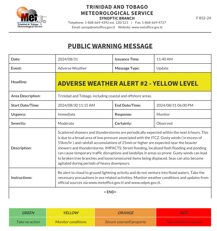
The Trinidad and Tobago Meteorological Service updated an Adverse Weather Alert (Yellow Level) on Saturday at 11:40 AM. The alert went into effect for Trinidad at 11:15 AM Friday, August 30th, 2024, and has been extended until 6:00 PM Saturday, August 31st, 2024.
As mentioned earlier, the forecast of inclement weather is due to several weather features affecting Trinidad and Tobago.
This “alert” status considers the possibility of the event occurring. This adverse weather event has been observed, and the following impacts are very likely/observed, according to the TTMS:
- Scattered showers and thunderstorms are periodically expected within the next 24 hours. This is due to a broad area of low pressure associated with the ITCZ.
- Gusty winds (in excess of 55 KM/H) can cause broken tree branches and the displacement of loose/unsecured items.
- Rainfall accumulations of 25mm or higher are expected near the heavier showers and thunderstorms.
- Street flooding, localized flash flooding, and ponding can cause temporary traffic disruptions and landslips in prone areas.
- Seas can also become agitated during periods of heavy downpours.

The alert’s color indicates the severity of the event and the probability of its occurrence. Currently, the alert level is Yellow. This means that the hazards are very likely or observed, and the severity of the impacts is moderate for this particular alert. You should be aware of the hazards in your area, which are associated mainly with street/flash flooding, landslides, gusty winds near 55 KM/H, possibly falling trees, and agitated seas.
A moderate Adverse Weather Alert can result in possible injuries, and behavioral changes are required to ensure safety. Minor damage to property may also occur, temporarily disrupting income-earning activities and affecting a couple of communities.
The Met Office advises the public to be alert to cloud-to-ground lightning activity, not venture into flood waters, take necessary precautions in sea-related activities, and monitor weather conditions and updates from official sources.


