What you need to know
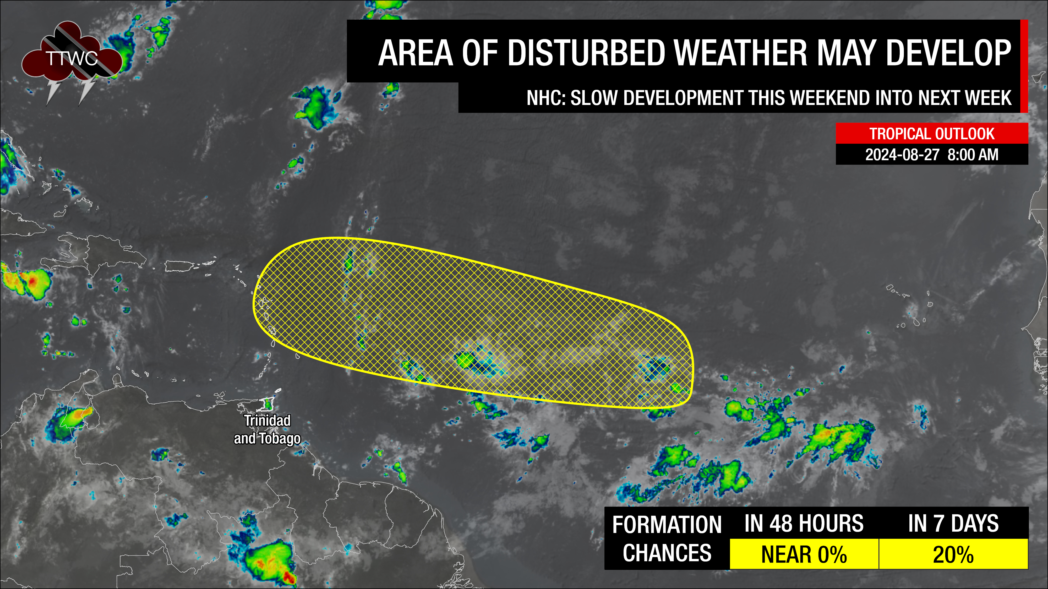
— Area of Disturbed Weather: The National Hurricane Center is monitoring an area where an area of low pressure may form this weekend into early next week. This eventual system is forecast to generally track north of Trinidad and Tobago between September 2nd and 4th.
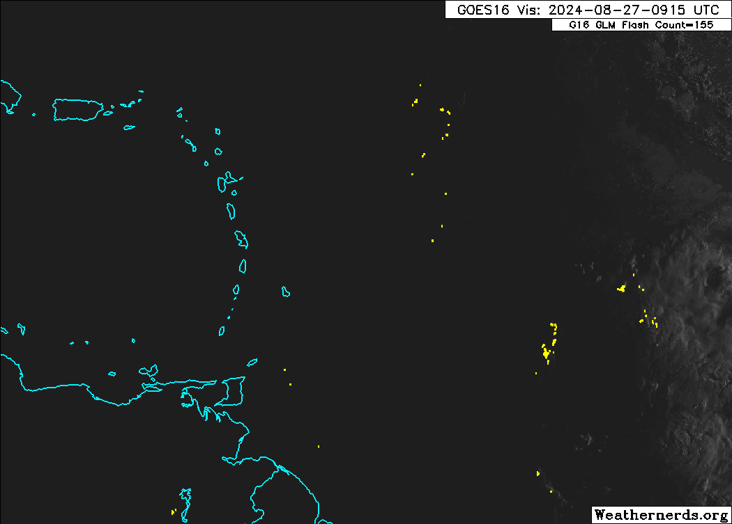
— Tropical Wave 33: This tropical wave is located along 54W, moving west at 10-15 knots. Scattered moderate to locally strong convection is noted where the wave interacts with the Intertropical Convergence Zone/Monsoon Trough. This wave is forecast to move across the Lesser Antilles on Wednesday, interacting with the Intertropical Convergence Zone/Monsoon Trough, bringing cloudiness and rainfall to T&T.
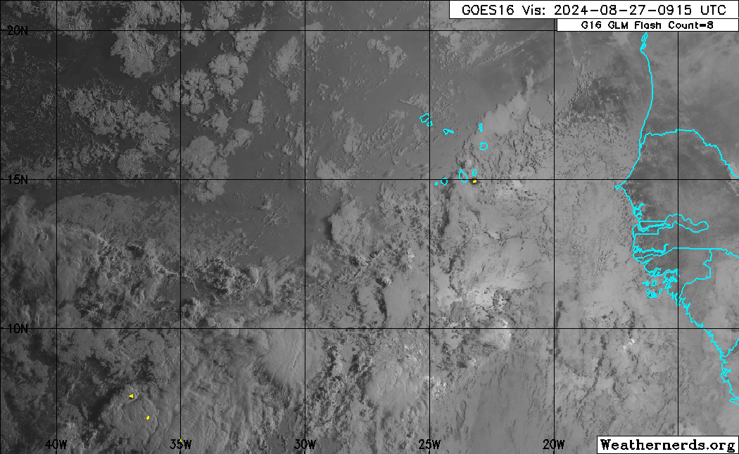
— Tropical Wave 34: This tropical wave is located further east, in the far eastern Atlantic Ocean, along 27W, moving west at 5-10 knots. Scattered moderate to locally strong convection is noted where the wave interacts with the Intertropical Convergence Zone/Monsoon Trough. This slow-moving wave is forecast to arrive during the early to middle portion of next week across the Lesser Antilles.
— Hazards for T&T: Both tropical waves and the area of disturbed weather are forecast to track north of T&T. Daily this week, showers and thunderstorms are forecast to affect Trinidad and Tobago mainly due to the Intertropical Convergence Zone. Then, due to TW33 and the approaching area of disturbed weather, the wind regime across T&T is forecast to be light from the south to variable, leading to isolated afternoon shower and thunderstorm activity favoring western and hilly areas, as well as the potential for funnel cloud development, particularly from Wednesday.
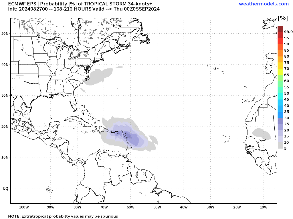
Area of Disturbed Weather
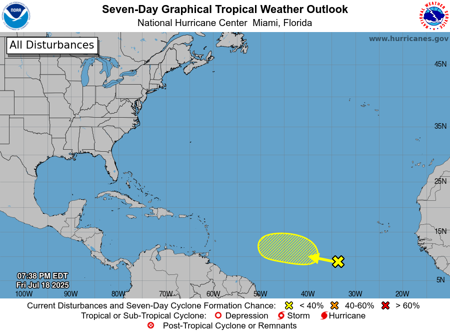
According to the NHC, “An area of low pressure could form in the central portion of the Tropical Atlantic in a few days. Thereafter, environmental conditions appear generally favorable for some slow development of this system this weekend into early next week as it moves westward to west-northwestward at 10 to 15 mph.”
At 8:00 AM Tuesday, the NHC gave near 0% development chances over the next 48 hours and 20% over the next seven days.
Forecast models now show modest development odds associated with a disturbance rolling into the central Atlantic this weekend. The system will likely come together partly from a long strip of storminess dangling into the central Atlantic from the coast of Africa known as the monsoon trough – a cousin of the Intertropical Convergence Zone. This collision zone of winds and airmasses is a notorious instigator of tropical saplings. However, exactly where within the wider zone of storminess the system sets up is a little unclear yet.
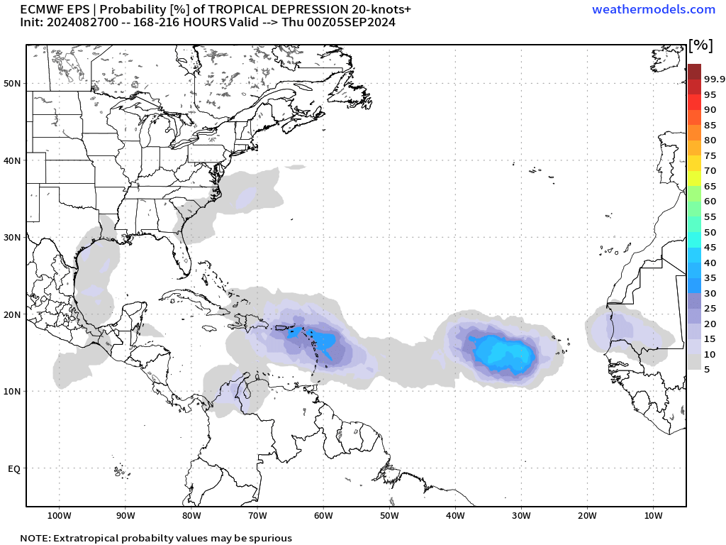
Based on the GEFS and EPS (top global ensemble models), less than 35% of models show winds greater than 37 KM/H, and less than 20% show winds stronger than 63 KM/H.
Forecast models are all over the place on what may happen beyond early next week, so we’ll need to give this one a little time to shake out. The general flavor is the system continues moving near or north of the Greater Antilles, including Puerto Rico, the U.S. Virgin Islands, Haiti, and the Dominican Republic from next Wednesday through Friday.
For Trinidad and Tobago, this system is forecast to reduce overall winds across the Windwards, leading to warm days, locally strong, northward-moving showers, and thunderstorms from the late morning through afternoon, favoring western and hilly areas of Trinidad.
During the evening, as the Intertropical Convergence Zone remains near/across T&T, some north/northwestward moving showers and thunderstorms that develop along Venezuela’s northern coastline may also affect particularly southern and southwestern Trinidad from this weekend into next week.
Tropical Waves 33 & 34
The next tropical wave is forecast to move across Trinidad and Tobago and the Lesser Antilles from tonight through Wednesday.
Scattered moderate to locally strong convection (showers and thunderstorms) are noted where the wave interacts with the Intertropical Convergence Zone/Monsoon Trough.
Forecast models show that overall rainfall totals are forecast to remain low, below 25 millimeters, through Thursday. However, the potential for heavy downpours in showers and thunderstorms, particularly during the afternoon on Wednesday and Thursday, localized rainfall totals may range between 25 and 50 millimeters, favoring Trinidad. As a result, localized street/flash flooding, gusty winds, intense lightning, and, from Wednesday, the possibility of funnel cloud development exist.
The Intertropical Convergence Zone/Monsoon Trough is forecast to remain across T&T and the Windwards into the weekend, keeping unstable conditions, elevated moisture, and light and variable winds. This will lead to a repeat of hot sunny days, interrupted by locally intense showers and thunderstorms from the late morning through the afternoon into the weekend and even early next week.
By next week, as the possible area of low-pressure moves across the Leewards, trailing this will be Tropical Wave 34 (and forecast models show these two features will be closely linked or even merge), bringing further unsettled conditions Tuesday through Thursday of next week.
Not Every Tropical Wave Brings Severe Weather
Tropical waves vary in intensity as they travel westward across the Atlantic. This variability can be in the order of days or as short term as hours. Sometimes, you may see satellite imagery that shows heavy thunderstorms and deep convective activity east of Trinidad and Tobago during the late night and early morning, but by daybreak – nothing.
This is due to diurnal (daily) variations in convective showers whereby convection peaks overnight and wanes during the day for already occurring convective systems (i.e., not triggered by daytime heating).
Activity can be enhanced by its proximity to upper-level troughs and the ITCZ but can also be degraded by hostile upper-level conditions and Saharan Dust.
However, it’s almost September, the peak month of hurricane season, so be ready for a busy few weeks ahead.