


Tropical Storm Ernesto, the fifth-named system for 2024, has formed in the Atlantic, 475 kilometers east-southeast of Antigua, at 5:00 PM Monday, August 12th, 2024.
According to the National Hurricane Center, this system is forecast to slow down and gradually strengthen over the next few days as it traverses the Leewards and then moves north of the Greater Antilles.
Based on the forecast path, this system is forecast to remain well north of T&T, bringing tropical storm conditions and heavy rainfall to the Leewards tonight. However, this fairly large low-pressure area will influence winds and atmospheric conditions across the Lesser Antilles through Wednesday.
What you need to know
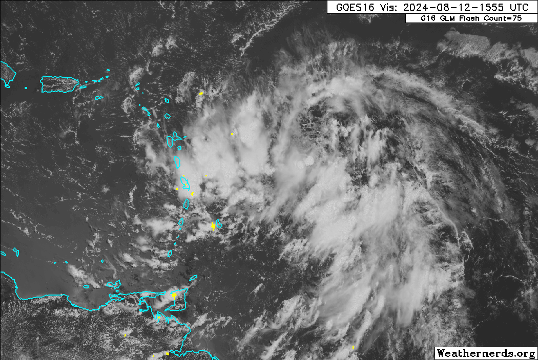
— What has happened: Potential Tropical Cyclone Five has been designated Tropical Storm Ernesto and is forecast to move across the Leewards starting tonight (Monday night). Convergence ahead of this low-pressure system already produced scattered showers and thunderstorms across the region on Monday. In T&T, light winds from the west, with a steering flow from south to north, allowed for slow-moving showers and thunderstorms to produce impactful flooding across northern areas.
— Where is it forecast to move: The National Hurricane Center show Tropical Storm Ernesto will begin moving across the Leewards after midnight tonight and across the eastern-most Greater Antilles overnight Tuesday into Wednesday morning.
— The Intensity & Impacts: Tropical storm conditions are expected across the Leewards from Guadeloupe to Puerto Rico, with locally heavy rainfall and agitated seas likely across the Lesser Antilles over the next 24 hours.
— Latest from officials: Tropical Storm Warnings are in effect from Guadeloupe through Puerto Rico, including all islands in the Leewards. Elsewhere, several islands have watches and warnings posted for rough seas, flooding and landslides. An Adverse Weather Alert has been issued for T&T, going into effect from 1:00 AM
The latest

At 5:00 PM, the center of Tropical Storm Ernesto was located near latitude 16.0 North and longitude 57.5 West. Ernesto is moving toward the west-northwest near 44 KM/H. A westward to west-northwestward motion with some decrease in forward speed is expected during the next couple of days. On the forecast track, Ernesto is expected to move across portions of the Leeward Islands late tonight or Tuesday and near or over the U.S. and British
Virgin Islands and Puerto Rico by Tuesday evening. Ernesto is then forecast to turn northward over the western Atlantic.
Maximum sustained winds have increased to near 65 KM/H with higher gusts. Gradual strengthening is expected during the next few days. Tropical-storm-force winds extend outward up to 95 kilometers from the center. The estimated minimum central pressure is 1009 millibars.
On Monday, satellite images and data from the Air Force Hurricane Hunters indicated that a center of circulation has now formed, and deep convection is gradually organizing in bands around that feature. According to the National Hurricane Center, incoming data supported increasing the sustained wind speeds to 35 knots (65 KM/H), meeting the definition of a tropical cyclone and having tropical storm-force winds.
Latest Alerts, Watches & Warnings

Tropical Storm Warnings
A Tropical Storm Warning is in effect for:
- St. Kitts, Nevis, Montserrat, Antigua, Barbuda, and Anguilla
- Guadeloupe
- St. Martin and St. Barthelemy
- Sint Maarten
- British Virgin Islands
- U.S. Virgin Islands
- Puerto Rico
- Vieques
- Culebra
A Tropical Storm Warning means that tropical storm conditions are expected somewhere within the warning area within 36 hours.
Other Alerts, Watches, and Warnings
Barbados
The Barbados Meteorological Service has the following in effect:
- Excessive Rainfall: Over the last 12 hours, rainfall accumulations between 1 and 2 inches were observed across the island. As Tropical Storm Ernesto passes north of the island tonight, heavy to intense showers and thunderstorm activity will remain likely and a further 1 to 2 inches are possible across the island. As a result, the Flash-Flood Watch remains in effect overnight.
- Marine (Yellow-Level): Peak open water waves between from 2.0 to 2.5 meters ( 7 to 8 ft ) and increasing.
- Severe Thunderstorms: Strong thunderstorms are possible through Monday night, with a yellow-level alert issued.
Trinidad and Tobago
Latest Alerts

TTMS Issues Adverse Weather Alert For T&T
Trinidad and Tobago is NOT under any tropical storm or hurricane threat, watch, or warning at this time.
Grenada
No alerts, watches, or warnings are in effect from the Grenada Meteorological Service.
St. Vincent and the Grenadines
- Weather Advisory: Excess rainfall over the next 24 hours due to thunderstorms/showers through Tuesday. Flooding and landslides possible
- Marine Advisory: Above normal sea swells up to 2.5 meters and occasional gusty winds from Tuesday morning through Wednesday.
- Flash Flood Watch: 75-100 millimetres of rainfall forecast.
St. Lucia
No alerts, watches, or warnings are in effect from the Saint Lucia Meteorological Service. However, Residents and motorists in areas prone to flooding and landslides are advised to exercise caution.
Where is it going?

Forecast models show Tropical Storm Ernesto being steered west-northwest by a strong low- to mid-level ridge, which is expected to continue through Tuesday night. However, a significant slow-down is forecast, and Ernesto is expected to turn north over the Atlantic Ocean due to a deep-layered trough that moves off the U.S. East Coast, shifting the ridge eastward.
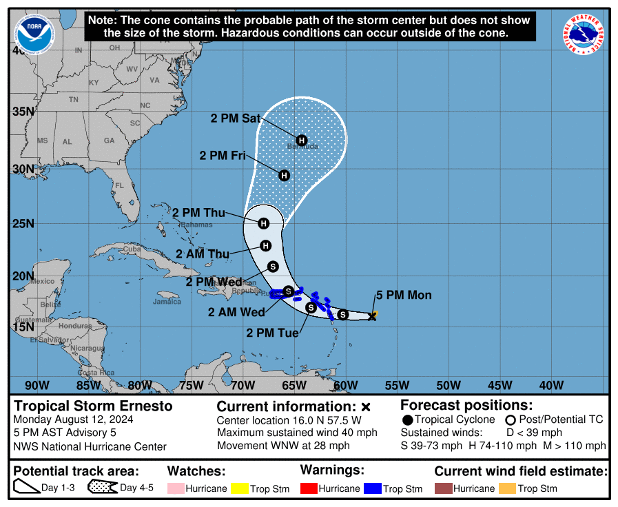
After Ernesto moves across the Leewards, the system is poised to move northward, nearing Bermuda by the end of the week. It’s too soon to say whether Ernesto will pose a direct threat to Bermuda in the future, but it will be in the vicinity of the British archipelago, so interests there should monitor the forecasts closely this week.
The late-week escape route will keep future Ernesto well east of the United States, but depending on how big or strong it grows, dangerous swells could reach the shoreline of the Eastern Seaboard by later this week or next weekend.
How strong could it get?
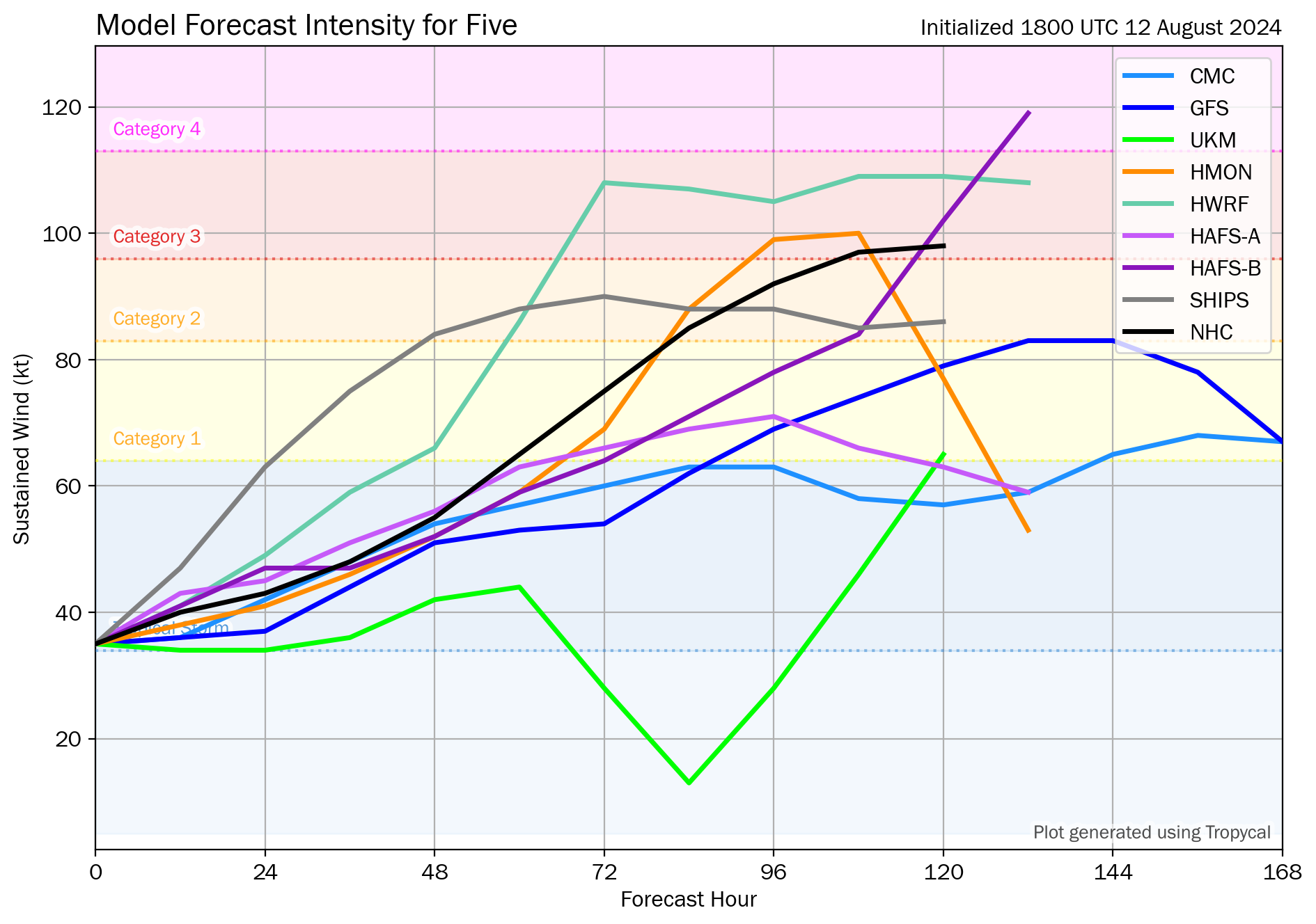
On Monday, Ernesto developed a center and improved circulation, which has poised the system to strengthen gradually. The NHC says the rate of intensification will likely be slow during the next day or two due to the system’s broad structure and ragged convective pattern.
More significant strengthening is forecast after Ernesto exits the Caribbean, when nearly all of the environmental conditions appear conducive.
What does this mean for the Lesser Antilles?
Tropical Storm Ernesto is forecast to bring heavy rainfall, tropical-storm-force winds, and storm surge and waves to the Leewards, from Guadeloupe to Puerto Rico. As Ernesto moves north, swells are also forecast to propagate across the Atlantic, potentially affecting the Lesser Antilles by the weekend into early next week.
Tropical cyclone preparedness plans should be rushed to completion for those in the Leewards. Heavy rainfall is likely to produce floods, landslides, and mudslides, as well as strong winds and gusts that can cause wind damage and rough seas.
Wind
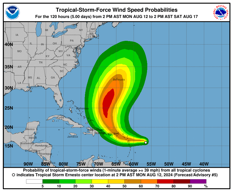
Based on the latest guidance, tropical storm-force wind gusts and sustained winds (above 34 knots, 39 MPH, 63 KM/H) are forecast to primarily affect the Leewards from Guadeloupe to Puerto Rico.
As Tropical Storm Ernesto moves across the Leewards, T&T will experience near-calm to westerly winds tonight, then near-calm to southerly winds through Tuesday, and southeasterly winds on Wednesday. This will lead to a high chance of showers and thunderstorms, particularly as activity moves north from Venezuela toward T&T. Wind gusts can range between 45 KM/H and 55 KM/H through Tuesday night, mainly across Tobago and in strong shower or thunderstorm activity.
Rainfall

The highest rainfall accumulations are forecast to occur across the Northern Windwards and Leewards, as well as portions of the Greater Antilles.
For northern South America, T&T, Barbados, Grenada and St. Vincent and the Grenadines, between 25 and 50 millimeters of rainfall is forecast, with isolated totals up to 100 millimeters. For T&T, locally higher totals along western and northern Trinidad and Tobago are possible due to locally intense showers or thunderstorms.
For northern St. Vincent, St. Lucia, Martinique, Antigua and Barbuda, Anguilla, Sint Marteen, and Saint Martin rainfall totals between 50 and 100 millimeters are possible, with isolated higher totals.
The highest rainfall accumulations, between 100 and 150 millimeters, are forecast across Dominica, Guadeloupe, Montserrat, St. Kitts and Nevis, the U.S. and British Virgin Islands, and even higher totals, up to 200 millimeters are possible for Puerto Rico – including Vieques and Culebra.
Seas and Storm Surge
A storm surge will raise water levels by as much as 1 to 3 feet above ground level for the eastern coast of Puerto Rico from San Juan to Guayama, including the islands of Culebra and Vieques and in the U.S. Virgin Islands, including St. Thomas, St. John, and St. Croix.
A storm surge will raise water levels by as much as 1 to 3 feet above normal tide levels in the British Virgin Islands. Near the coast, the surge will be accompanied by large and destructive waves.
For islands under a Tropical Storm Warning, seas may reach as high as 3.0 meters in open waters, which are hazardous for small craft operators. Large waves are also likely near coasts.
For Trinidad and Tobago
For Trinidad and Tobago, given that this system is forecast to remain well north of the country, feeder band activity is unlikely. However, Ernesto’s influence on T&T’s atmosphere is forecast to continue through Wednesday.
On Monday night, low-level winds are forecast to come from the southwest, which may lead to late-evening thunderstorms that develop across northern Venezuela and move toward southern Trinidad overnight. These thunderstorms will bring locally heavy rainfall to southern Trinidad, frequent lightning, and agitated conditions in the Gulf of Paria, particularly south and west-facing coastlines.
On Tuesday, low-level wind speeds are forecast to increase, remaining from the south, leading to northward-moving showers and thunderstorms that likely will develop from the late morning through the afternoon. Sea breeze convergence and daytime heating act as triggers for shower/thunderstorm development. Locally intense activity is possible across Tobago, northern and western Trinidad.
On Monday evening through Tuesday night, with southerly to southwesterly winds, strong evening thunderstorms may also move off the Venezuelan coastline south of Trinidad and move toward the country in the Gulf of Paria, creating hazardous marine conditions and producing frequent, dangerous lightning.
Then, on Wednesday, as Ernesto pulls away from Trinidad, southeasterly winds are forecast to prevail, with conditions gradually improving as a high-pressure ridge rebuilds and a drier, more stable air mass moves over the region.
Pay close attention to official forecasts from your respective authorities in the coming hours and days. The Trinidad and Tobago Meteorological Service provides official forecasts and early warnings for Trinidad and Tobago.


