


With approaching showers and thunderstorms associated with Tropical Wave 24 and a surge in the trade winds, interacting with the Intertropical Convergence Zone, the Trinidad and Tobago Meteorological Service has issued a late-notice Adverse Weather Alert for the country.
What you need to know
— Rainfall: Over the next 24 hours, forecast models show rainfall accumulations across Trinidad and Tobago between 12.5 and 37.5 millimeters, but high-resolution modeling shows localized totals across parts of Trinidad receiving as high as 75 millimeters of rainfall. Generally, the northern and eastern halves of Trinidad are forecast to record the highest rainfall accumulations, with isolated high totals elsewhere. Conditions are forecast to settle by the afternoon across T&T.
— Hazards: The main hazards will be gusty winds between 45 KM/H to 65 KM/H, accompanying heavy showers and thunderstorms, which will produce cloud-to-ground lightning. As a result of periods of heavy/violent rainfall, street/flash flooding are likely. Due to relatively saturated soils, landslides are likely in elevated areas, particularly along the Northern Range and windward slopes of Tobago. Seas are forecast to become locally agitated during heavy showers or thunderstorms.
Latest Alerts

High Wind Alert Remains In Effect For T&T
Trinidad and Tobago is NOT under any tropical storm or hurricane threat, watch, or warning at this time.
The Adverse Weather Alert
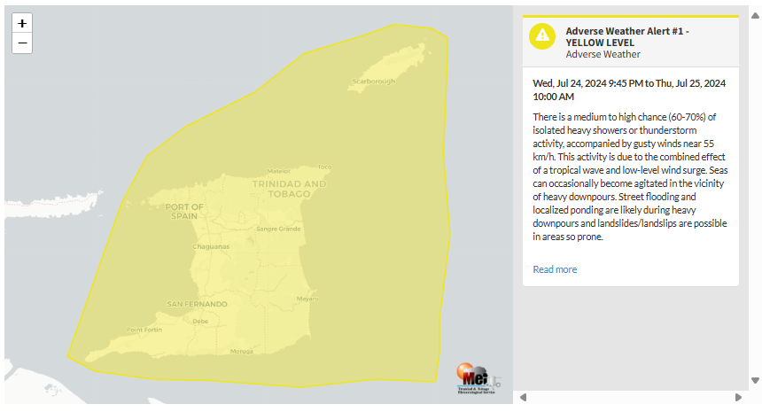
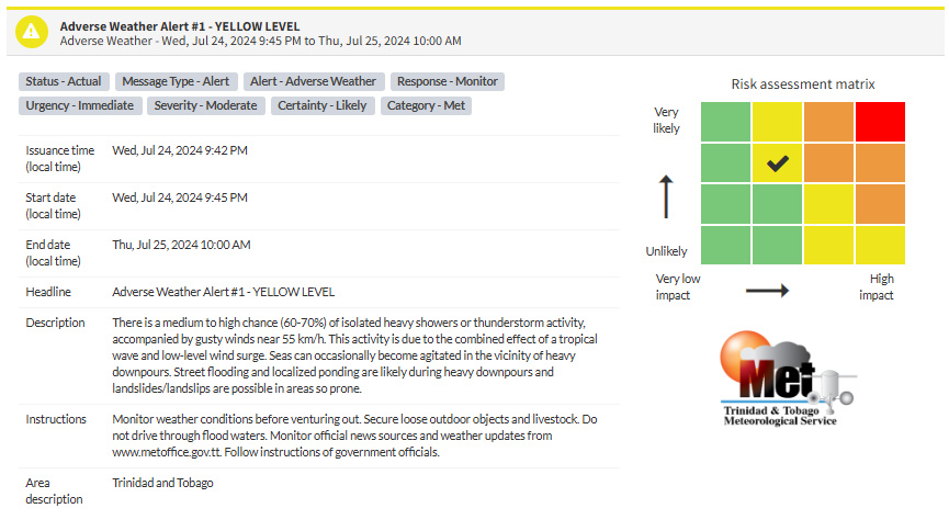
The Trinidad and Tobago Meteorological Service issued the Adverse Weather Alert (Yellow Level) on Wednesday at 9:42 PM. The alert went into effect at 9:45 PM Wednesday, July 24th, 2024, for Trinidad and Tobago and remains in effect for the country until 10:00 AM Thursday, July 25th, 2024.
As mentioned earlier, the forecast of inclement weather is due to a tropical wave and trade wind surge interacting with the Intertropical Convergence Zone across T&T.
This “alert” status considers the possibility of the event occurring. This adverse weather event is likely to have the following impacts, according to the TTMS:
- There is a medium to high chance (60-70%) of isolated heavy showers or thunderstorm activity accompanied by gusty winds near 55 KM/H.
- Seas can occasionally become agitated in the vicinity of heavy downpours.
- Street flooding and localized ponding are likely during heavy downpours
- Landslides/landslips are possible in areas so prone.

The alert’s color indicates the severity of the event and the probability of its occurrence. Currently, the alert level is Yellow. This means that the hazards are likely, and the severity of the impacts is moderate for this particular alert. You should be aware of the hazards in your area associated mainly with street/flash flooding, landslides, gusty winds near 55 KM/H possible falling trees, and agitated seas.
A moderate Adverse Weather Alert can result in possible injuries and behavioral changes are required to ensure safety. Minor damage to property may also occur, temporarily disrupting income-earning activities and affecting a couple of communities.
The Met Office is advising the public to monitor weather conditions before venturing out, secure loose outdoor objects and livestock, do not drive through flood waters, monitor official news sources and weather updates and follow instructions of government officials.


